Satellite/vision/laser combined urban canyon environment UAV positioning and navigation method

An urban canyon, positioning and navigation technology, applied in the field of measurement and testing, can solve the problems of insufficient positioning and navigation accuracy of drones, high computational complexity, occlusion and reflection, etc., to meet all-weather flight and operations, reduce calculations, reduce Effect of Small Errors and Computational Efforts

Active Publication Date: 2020-03-27
NANJING UNIV OF AERONAUTICS & ASTRONAUTICS
View PDF12 Cites 14 Cited by
  • Summary
  • Abstract
  • Description
  • Claims
  • Application Information

AI Technical Summary

Problems solved by technology

[0007] The object of the invention of the present invention is to address the deficiencies of the above-mentioned background technology, and provide a satellite/vision/laser combination UAV positioning and navigation method for urban canyon environment, by combining vision, laser and the 2D city ideal skyline database constructed by 3D map information to determine and receive Signal type, so as to eliminate non-line-of-sight receiving (NLOS, Non-Line-of-Sight) signals for positioning calc...

Method used


Image

  • Satellite/vision/laser combined urban canyon environment UAV positioning and navigation method
  • Satellite/vision/laser combined urban canyon environment UAV positioning and navigation method
  • Satellite/vision/laser combined urban canyon environment UAV positioning and navigation method

Examples


Embodiment Construction

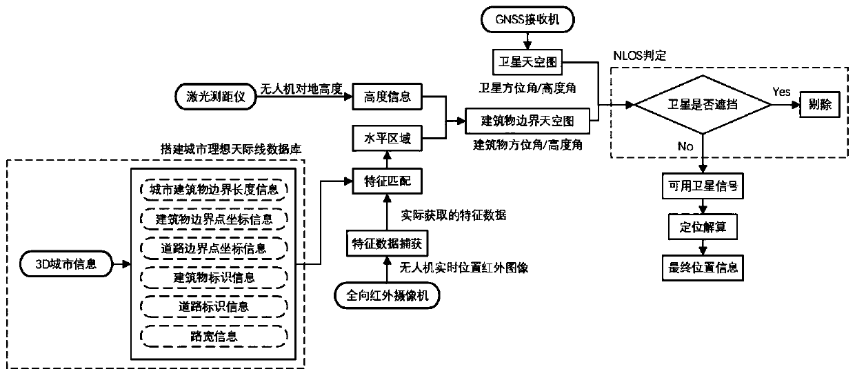
[0021] The technical solution of the invention will be described in detail below in conjunction with the accompanying drawings. The specific scheme of the UAV positioning and navigation method based on satellite / vision / laser combination in the urban canyon environment is as follows: figure 1 As shown, it includes the following five steps.

[0022] (1) Building a city skyline database

[0023] According to the 3D map information, extract the characteristic information of buildings and roads to construct a 2D ideal city skyline database in advance. The data information contained in the database mainly includes: urban building boundary length information, building boundary point coordinate information, building identification information, road width information, road boundary point coordinate information, road identification information, etc.

[0024] (2) Obtain the initial spatial position of the UAV

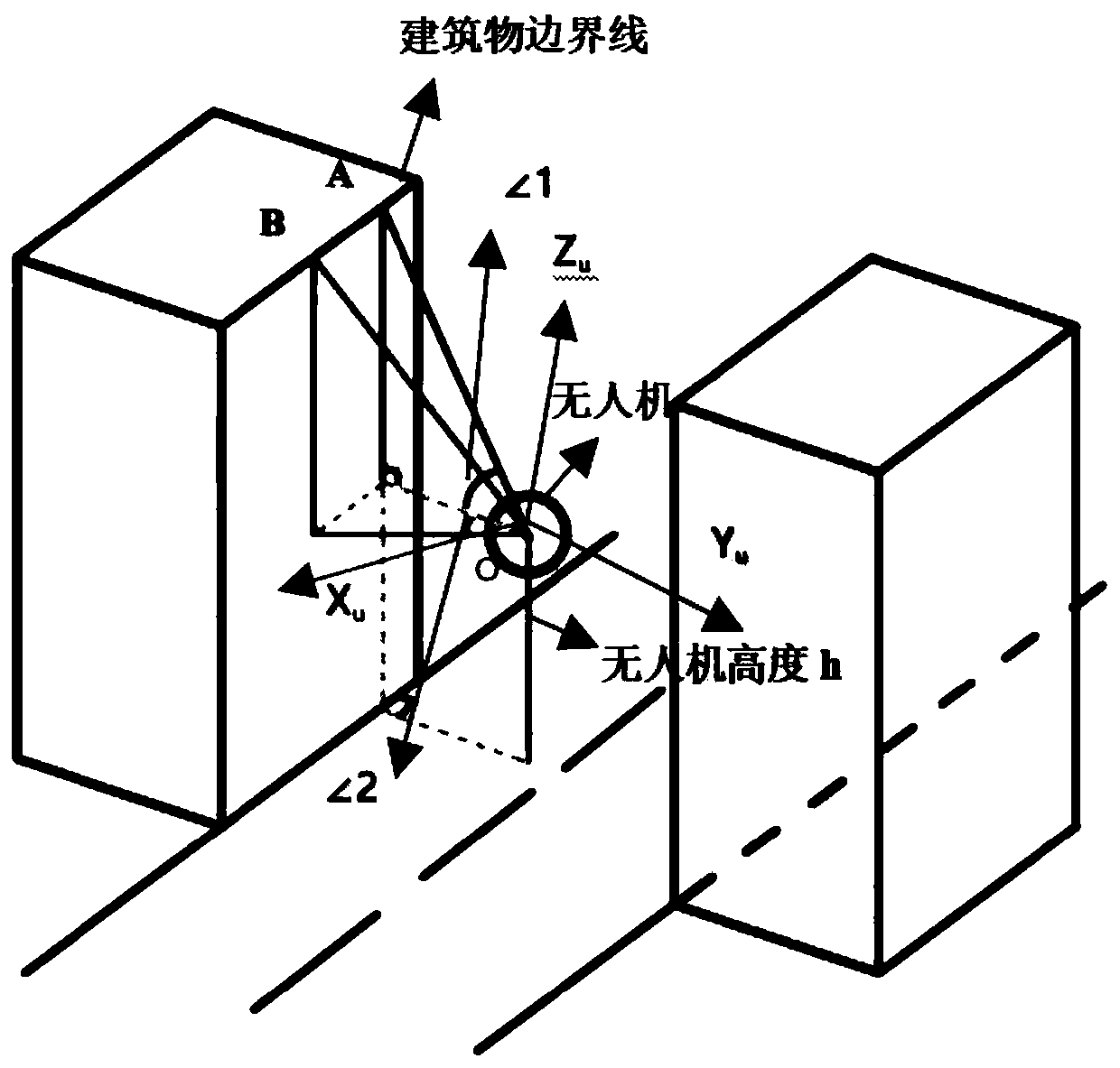
[0025]Use an omnidirectional infrared camera to capture the sky direct...


PUM


Abstract

The invention discloses a satellite/vision/laser combined urban canyon environment UAV positioning and navigation method, and belongs to the technical field of measurement and testing. The method comprises the following steps: acquiring a sky image by using an omnidirectional infrared camera; extracting partial data in the 3D city information to construct a city ideal skyline database; obtaining horizontal position information of the unmanned aerial vehicle by comparing building skyline information extracted from the infrared image with an urban ideal skyline database; determining height information of the unmanned aerial vehicle by laser ranging; constructing a building boundary sky map according to the initial position information of the unmanned aerial vehicle and the building boundaryinformation; superposing a building boundary sky map and a satellite sky map to mine a multi-path judgment rule; calculating the final position information of the unmanned aerial vehicle, interferencecaused by light rays such as night light weakening is avoided, the calculation complexity is reduced, image processing feature extraction is easy to achieve, errors and the calculation amount causedby direct scene matching can be reduced, and the requirements of all-weather flight and operation of the unmanned aerial vehicle can be met.

Description

technical field [0001] The invention discloses a satellite / vision / laser combination UAV positioning and navigation method in an urban canyon environment, which belongs to the technical field of measurement and testing. Background technique [0002] In recent years, with the development and popularization of commercial and civilian unmanned aerial vehicles (UAV, Unmanned Aerial Vehicle), drones have been applied to many fields, such as urban express drones for areas with large logistics density, urban emergencies Emergency rescue UAV auxiliary system and urban traffic dynamic monitoring UAV for smart city construction, etc. Therefore, the positioning and navigation problem of urban UAV needs to be solved urgently. At present, Global Navigation Satellite System (GNSS, Global Navigation Satellite System) can provide a low-cost, continuous global solution for positioning, and has become an important positioning and navigation equipment for UAVs. However, in the urban canyon env...

Claims


Application Information

Patent Timeline
IPC IPC(8): G01C21/20G01C21/00G01S19/45G01S19/22G01S17/933
CPCG01C21/005G01C21/20G01S17/933G01S19/22G01S19/45
Inventor 孙蕊傅麟霞彭聪何伟曹阳威
Owner NANJING UNIV OF AERONAUTICS & ASTRONAUTICS
Why Eureka
Try Eureka