
OBS precise positioning method based on acoustic ranging and multi-beam terrain

A precise positioning, multi-beam technology, used in seismology, measuring devices, scientific instruments, etc., can solve problems such as lack of correction

Active Publication Date: 2020-02-21
SECOND INST OF OCEANOGRAPHY MNR
View PDF8 Cites 4 Cited by
  • Summary
  • Abstract
  • Description
  • Claims
  • Application Information

AI Technical Summary

Problems solved by technology

However, for passive source seismic observation experiments, due to the limitation of ship time and funds, active source blasting operations are often not carried out, and the OBS position is usually not well corrected

Method used


Image

  • OBS precise positioning method based on acoustic ranging and multi-beam terrain
  • OBS precise positioning method based on acoustic ranging and multi-beam terrain
  • OBS precise positioning method based on acoustic ranging and multi-beam terrain

Examples


Embodiment Construction

[0031] The present invention will be described in further detail below in conjunction with the accompanying drawings and specific embodiments.

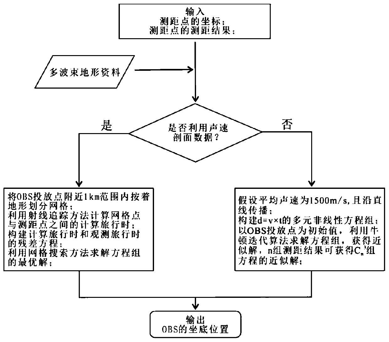
[0032] The present invention provides an OBS precise positioning method based on underwater acoustic ranging and multi-beam terrain, comprising the following steps:

[0033] At the OBS delivery point (x 0 ,y 0 ,z 0 ) n (n≥3) sea surface ranging points (x 1 ,y 1 ,z 1 ; x 2 ,y 2 ,z 2 ; x 3 ,y 3 ,z 3 ;...;x n ,y n ,z n ), use the acoustic communication device to perform acoustic ranging on the OBS, and obtain the corresponding ranging result as d 1 , d 2 , d 3 ,...,d n , unit m;

[0034] According to whether there is sound velocity profile data in the sea area where the OBS is deployed, it is divided into two cases: the first case, the sound speed profile data is not considered; the second case, the sound speed profile data is considered;

[0035] 1. The first situation is as follows:

[0036] According to the average...


PUM


Abstract

The invention discloses an OBS precise positioning method based on underwater acoustic ranging and multi-beam terrain. Firstly, an acoustic communication machine is used to measure the distance of theOBS within the effective range of the OBS delivery point; when the sound velocity profile is not considered, the nonlinear equations are constructed by the relationship between the slant distance from the OBS to the ranging point and the travel time, and the bottom position of the OBS is obtained by solving the equations with Newton iterative algorithm; when the sound velocity profile is considered, the multi-beam seabed terrain near the OBS delivery point is gridded, according to the sound velocity profile, the calculated travel time between each grid point and the ranging point is calculated by using the ray tracing method, and the residual equations for calculated travel time and observed travel time between OBS and each ranging point are constructed; the grid search method is used tosolve the optimal solution of the residual equations, that is, the bottom position of the OBS. The method of the invention has the characteristics of simple operation, time-saving and accurate calculation, and realizes the accurate positioning of the OBS seabed for free falling body dropping.

Description

technical field [0001] The invention belongs to the technical field of submarine seismic observation, and relates to an accurate positioning method of a submarine seismograph (OBS) based on acoustic ranging and multi-beam topography. Background technique [0002] Submarine passive source seismic observation technology is to study mid-ocean ridge structures and magmatic activities by deploying OBS stations on the seabed for long-term observations and using the natural seismic signals received by them. Under normal circumstances, OBS is released to the bottom of the sea in the way of free fall. Due to the influence of ocean currents, there is a certain deviation between the bottom position of the OBS and the location of the release. The deviation of the OBS position will directly lead to an increase in the error of the seismic positioning results, so OBS position correction is required before seismic data processing. For the active source seabed seismic experiment, position c...

Claims


Application Information

Patent Timeline
IPC IPC(8): G01V1/18
CPCG01V1/186G01V2210/1427
Inventor 柳云龙陶春辉丘磊蔡巍张国堙周建平梁锦
Owner SECOND INST OF OCEANOGRAPHY MNR
Learn More