
A GIS-based agricultural multi-source big data fusion processing method and system

A technology that integrates processing and big data, applied in the field of agricultural management, can solve the problems of insufficient intelligence, inaccurate and rapid data collection, waste of manpower and material resources, etc., to achieve good economic benefits, increase output, and ensure the effect of accuracy

Active Publication Date: 2022-05-27
河池市农业区划委员会办公室 +1
View PDF7 Cites 0 Cited by
  • Summary
  • Abstract
  • Description
  • Claims
  • Application Information

AI Technical Summary

Problems solved by technology

[0005] The purpose of the present invention is to provide a GIS-based agricultural multi-source big data fusion processing method and system to solve the problems of waste of manpower and material resources in agriculture, lack of intelligence, and inaccurate and rapid data collection in the above-mentioned background technology

Method used


Image

  • A GIS-based agricultural multi-source big data fusion processing method and system
  • A GIS-based agricultural multi-source big data fusion processing method and system
  • A GIS-based agricultural multi-source big data fusion processing method and system

Examples


Embodiment Construction

[0031] The technical solutions in the embodiments of the present invention will be clearly and completely described below with reference to the accompanying drawings in the embodiments of the present invention. Obviously, the described embodiments are only a part of the embodiments of the present invention, but not all of the embodiments.

[0032] In the description of the present invention, it should be understood that the terms "center", "longitudinal", "lateral", "length", "width", "thickness", "upper", "lower", "front", " Back, Left, Right, Vertical, Horizontal, Top, Bottom, Inner, Outer, Clockwise, Counterclockwise, Axial , "radial", "circumferential" and other indicated orientations or positional relationships are based on the orientations or positional relationships shown in the accompanying drawings, and are only for the convenience of describing the present invention and simplifying the description, rather than indicating or implying the indicated device or Elements m...


PUM


Abstract

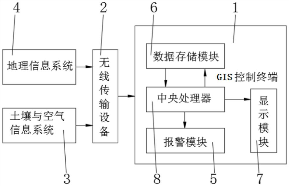
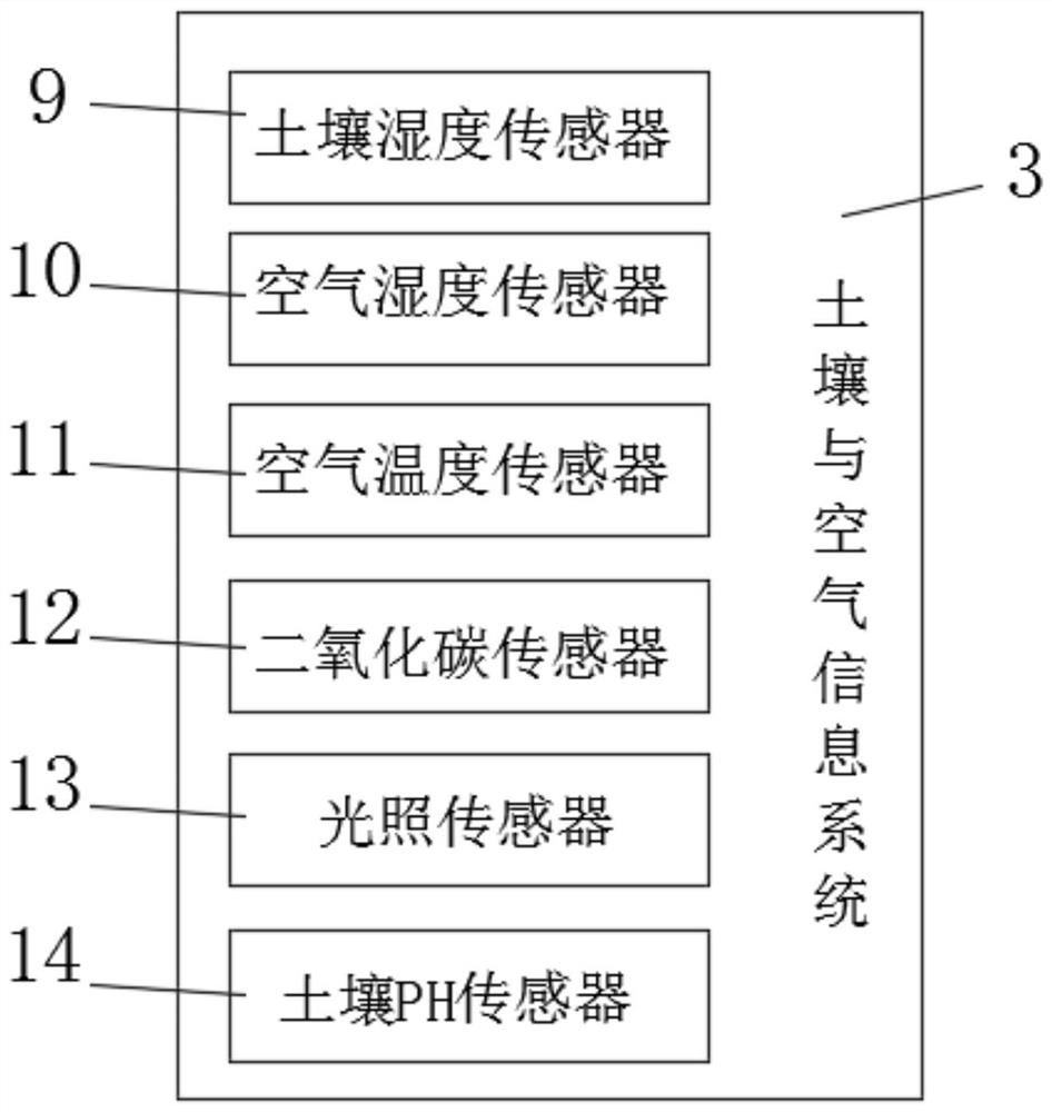
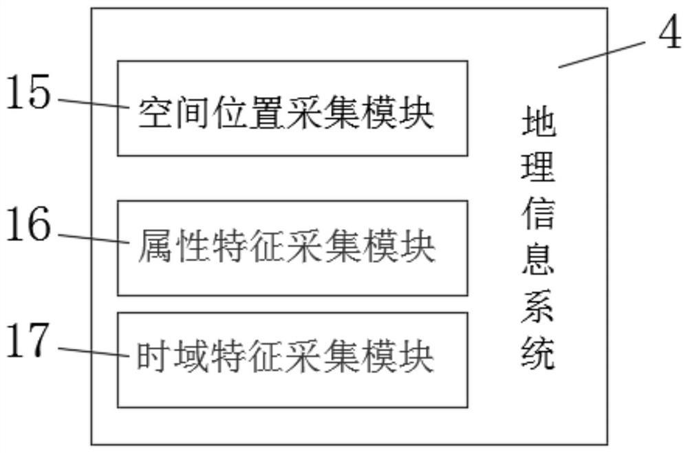
The invention discloses a GIS-based agricultural multi-source big data fusion processing system, which relates to the technical field of agricultural management and includes GIS control terminals, wireless transmission equipment, soil and air information systems and geographic information systems. The soil and air information systems include soil Humidity sensor, air humidity sensor, air temperature sensor, carbon dioxide sensor, light sensor and soil PH sensor. The invention also discloses a GIS-based agricultural multi-source big data fusion processing method, including the following steps: S1: soil and air data collection, S2: agricultural data collection, S3: geographical information data collection, S4: establishment of base map, S5: Establish dynamic distribution diagram, S7: Alarm dynamic distribution diagram, S8: Personnel operation. The present invention not only acquires the latitude and longitude coordinates of the earth, but also records the qualitative indicators of geographical element features and the occurrence time of geographical phenomena by setting a spatial position acquisition module, an attribute feature acquisition module, and a time domain feature acquisition module.

Description

technical field [0001] The invention relates to the technical field of agricultural management, in particular to a GIS-based agricultural multi-source big data fusion processing method and system. Background technique [0002] With the gradual realization of large-scale, automated and intelligent production in agricultural production, and due to people's requirements for the quality of life, more and more people have set up agricultural greenhouses to increase their income and improve their living standards. Some agricultural greenhouses and agricultural breeding are basically controlled manually. Since the indoor humidity, light or temperature are controlled manually by switching valves, adjusting the light intensity and ventilation status, this adjustment method not only wastes manpower and material resources, but also has low productivity. , it will also bring irreparable consequences due to artificial misjudgment or inaccurate adjustment, and then cause serious economic ...

Claims


Application Information

Patent Timeline
Patent Type & Authority Patents(China)
IPC IPC(8): G06V10/80G06K9/62G06T17/05G06F16/29G06Q50/02G01D21/02
CPCG06T17/05G06F16/29G06Q50/02G01D21/02G06F18/253
Inventor 余永久黄天亮孙佳龙葛吉栋罗宇灏蒲春艳罗金华余全民王亚亚
Owner 河池市农业区划委员会办公室
Learn More