Medium-and-small-scale soil water monitoring system and method based on cosmic ray neutron method and UAV (unmanned aerial vehicle) remote sensing

A cosmic ray and monitoring system technology, applied in the field of soil research tools, can solve the problems of irreplaceable, unable to provide moisture monitoring data, insufficient spatial resolution of high-altitude remote sensing, etc., to achieve the effect of high resolution and accurate monitoring

Active Publication Date: 2019-12-03
INST OF SOIL SCI CHINESE ACAD OF SCI
View PDF6 Cites 3 Cited by
  • Summary
  • Abstract
  • Description
  • Claims
  • Application Information

AI Technical Summary

Problems solved by technology

Although the combination of cosmic ray neutron method and high-altitude remote sensing can use CRNP data to calibrate the remote sensing retrieval results; however, due to the insufficient spatial resolution of high-altitude remote sensing, the research results cannot provide moisture monitoring data of small and medium scales with high spatial resolution[61]
For the purpose of this research, high-altitude remote sensing cannot replace UAV remote sensing
However, due to the limitations of technology development and work accumulation, there are still few researches on soil water monitoring that integrate cosmic ray neutron method and UAV remote sensing method.

Method used


Image

  • Medium-and-small-scale soil water monitoring system and method based on cosmic ray neutron method and UAV (unmanned aerial vehicle) remote sensing
  • Medium-and-small-scale soil water monitoring system and method based on cosmic ray neutron method and UAV (unmanned aerial vehicle) remote sensing
  • Medium-and-small-scale soil water monitoring system and method based on cosmic ray neutron method and UAV (unmanned aerial vehicle) remote sensing

Examples


Embodiment 1

[0041] This small and medium-scale soil water monitoring system combines cosmic ray neutron method and UAV remote sensing, including:

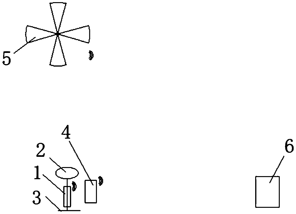
[0042] Cosmic ray fast neutron monitoring system, the system is composed of CRNP1, solar power supply system 2 and support 3, CRNP and solar power supply system are all erected on the support, and the solar power supply system supplies power to CRNP;

[0043] Automatic weather station 4 is arranged on the periphery of CRNP to measure relevant meteorological data such as air pressure and atmospheric relative humidity;

[0044] UAV remote sensing system, UAV with aerial photography function equipped with visible light, near-infrared, thermal infrared imaging and / or LiDAR device;

[0045] Remote data transmission system, used to transmit CRNP, automatic weather station, UAV remote sensing data to data processing center;

[0046] The data processing center 6 is used to receive and process the data monitored by CRNP, automatic weather station, and...

Embodiment 2

[0048] The medium and small-scale soil water monitoring method that combines the cosmic ray neutron method and UAV remote sensing, the steps include:

[0049] A. CRNP measures the number of cosmic ray fast neutrons near the surface of the measured area within a certain period of time;

[0050] B. The automatic weather station measures the air pressure and atmospheric relative humidity meteorological data of the measured area within the corresponding period, and uses the measured meteorological data to correct the air pressure and atmospheric water vapor content of the cosmic ray neutron data;

[0051] C. UAV remote sensing acquires remote sensing data within the range of the measured area, and processes the visible spectrum images, near-infrared spectrum images and thermal infrared images of the measured area into corresponding visible light orthomaps, near-infrared spectrum orthomaps and Vegetation index distribution map and corresponding digital surface model, thermal infrar...


PUM

PropertyMeasurementUnit
Radiusaaaaaaaaaa

Abstract

The invention discloses a medium-and-small-scale soil water monitoring system based on a cosmic ray neutron method and UAV (unmanned aerial vehicle) remote sensing. The system comprises a cosmic ray fast neutron monitoring system consisting of a CRNP, a solar power supply system and a support; an automatic meteorological station, which is arranged at the periphery of the CRNP and is used for measuring related meteorological data such as air pressure and atmospheric relative humidity; a UAV remote sensing system, which is an unmanned aerial vehicle which carries visible light, near infrared, thermal infrared imaging and / or laser ranging radar (LiDAR) devices and has an aerial photography function; a remote data transmission system; and a data processing center. The invention further provides a corresponding medium-and-small-scale soil water monitoring method. The invention fuses the advantages of accurate macroscopic soil water quantity monitoring of the cosmic ray neutron method and high spatial resolution of UAV (unmanned aerial vehicle) remote sensing and establishes a new medium-small-scale soil water monitoring method and device, and fills the technical blank between point-scale and remote sensing large-scale soil water monitoring.

Description

technical field [0001] The invention relates to a medium and small-scale soil water monitoring system and method which integrate cosmic ray neutron method and unmanned aerial vehicle remote sensing, and belong to the technical field of soil research tools. Background technique [0002] Soil water is an important part of water resources and plays a vital role in the near-surface matter-energy cycle. At present, many agricultural, hydrological, and environmental issues related to soil water, such as precise management of water and fertilizer in farmland, rational regulation of water resources, and control of non-point source pollutants, etc., all focus on small and medium scales ranging from tens of meters to thousands of meters[ 2,3]. The solution to the above problems largely depends on people's understanding of soil water distribution and change information at this scale. This requires people to accurately grasp the macroscopic soil water quantity and its dynamic changes ...

Claims


Application Information

Patent Timeline
IPC IPC(8): G01N23/00G01N21/25G01S17/88
CPCG01N21/25G01N23/005G01S17/88
Inventor 李晓鹏赵原刘金涛刘建立张佳宝
Owner INST OF SOIL SCI CHINESE ACAD OF SCI
Why Eureka
Try Eureka