A method for identification of moraine-covered glaciers combining polarization decomposition and topographic features
A technology of polarization decomposition and topographic features, applied in the field of remote sensing geosciences, can solve problems such as misclassification of glacier areas, and achieve the effects of strong operability, easy promotion, and improved classification results
- Summary
- Abstract
- Description
- Claims
- Application Information
AI Technical Summary
Problems solved by technology
Method used
Image
Examples
Embodiment Construction
[0038] The present invention will be described in detail below according to the accompanying drawings, so that the purpose and effect of the present invention will become more obvious.
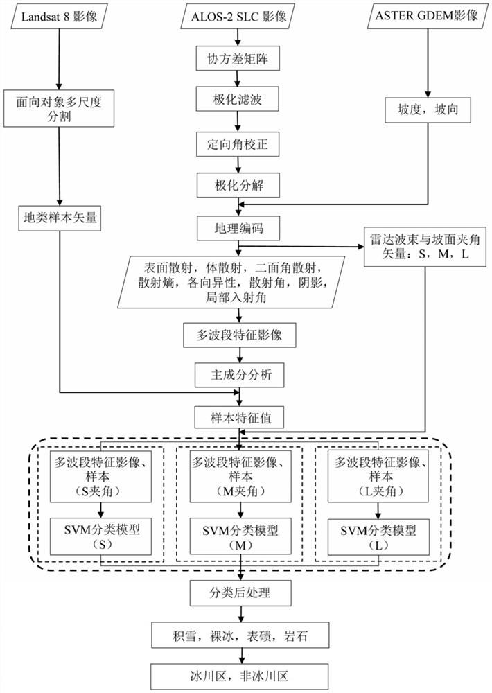
[0039] Such as figure 1 As shown, it is a flow chart of the method for identifying moraine-covered glaciers in this embodiment combining polarization decomposition and topographic features. The specific steps are as follows:
[0040] The first step is to calculate the coherence matrix after reading the scattering matrix of the SAR image, then perform ImprovedLee Sigma polarization filtering on the coherence matrix to remove the noise in the image, and finally perform azimuth correction to weaken the influence of terrain fluctuations on the polarization characteristics of electromagnetic waves.
[0041] In this step, the coherence matrix removes the influence of system noise by means of average calculation on the scattering matrix, and the Improved Lee Sigma polarization filter can retain more ...
PUM
 Abstract
Description
Claims
Application Information
 - R&D
- Intellectual Property
- Life Sciences
- Materials
- Tech Scout
- Unparalleled Data Quality
- Higher Quality Content
- 60% Fewer Hallucinations
Browse by: Latest US Patents, China's latest patents, Technical Efficacy Thesaurus, Application Domain, Technology Topic, Popular Technical Reports.
© 2025 PatSnap. All rights reserved.Legal|Privacy policy|Modern Slavery Act Transparency Statement|Sitemap|About US| Contact US: help@patsnap.com


