Boundary system for planning boundary demarcation of mountainous villages and towns

A boundary system and boundary technology, applied in data processing applications, instruments, calculations, etc., can solve problems such as the destruction of cultivated land resources, the random change of land planning boundaries, and the small area of ​​high-quality cultivated land, so as to improve work efficiency, management and service levels. Effect

Pending Publication Date: 2019-11-26
CHONGQING UNIV
View PDF16 Cites 0 Cited by
  • Summary
  • Abstract
  • Description
  • Claims
  • Application Information

AI Technical Summary

Problems solved by technology

[0002] At present, innovating social management has become a new task of my country's reform, and the focus should be on the countryside, because rural society is the foundation of our society. With the rapid development of the socialist market economy and the integration of cities and towns, the economic benefits of land in mountainous villages and towns have been greatly improved. However, at the same time, in the land management of mountainous villages and towns, there have also been problems such as the destruction of cultivated land resources, the occupation of farmland by building houses, and the random changes of land planning boundaries. Normal production, exploring an efficient land management model suitable for the planning boundaries of villages and towns in mountainous areas, and using information technology to strengthen land supervision and improve land utilization have become the key to solving the current land management problems in mountainous villages and towns

Method used


Image

  • Boundary system for planning boundary demarcation of mountainous villages and towns
  • Boundary system for planning boundary demarcation of mountainous villages and towns

Examples


Embodiment Construction

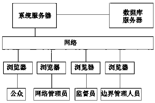
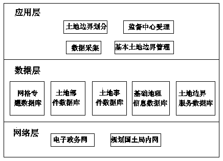
[0016] Shown in accompanying drawing, a kind of boundary system that is used for the planning boundary delineation of villages and towns in mountainous areas of the present invention comprises browser, system server, database server, and network manager utilizes browser to carry out network connection with system server through network, and public utilizes browser Connect to the system server through the network, the supervisor uses the browser to connect to the system server through the network, and the border management personnel uses the browser to connect to the system server through the network. The system server and the database server are electrically connected to the network. The system server is equipped with a system platform for electronic boundary demarcation.

[0017] Further, described system server adopts Linux operating system and PHP development programming language, has loaded the system server of Apache software.

[0018] Further, the database server is a da...


PUM


Abstract

A boundary system for planning boundary demarcation of mountainous villages and towns comprises a browser, a system server and a database server. A network administrator performs network connection with the system server through a network by utilizing a browser; the public performs network connection with the system server through a network by utilizing a browser; the boundary system for planningboundary demarcation of mountainous villages and towns improves the management and service level of planning boundary demarcation of mountainous villages and towns, realizes technical integration anddata sharing of basic geographic information and industry informatization, better exerts the benefit of public resources, and improves the working efficiency.

Description

technical field [0001] The invention relates to the technical field of village and town planning boundary delineation, in particular to a boundary system used for delimiting village and town planning boundaries in mountainous areas. Background technique [0002] At present, innovating social management has become a new task of my country's reform, and the focus should be on the countryside, because the rural society is the foundation of our society. With the rapid development of the socialist market economy and the integration of cities and towns, the economic benefits of land in mountainous villages and towns have been greatly improved. However, at the same time, in the land management of mountainous villages and towns, there have also been problems such as the destruction of cultivated land resources, the occupation of farmland by building houses, and the random changes of land planning boundaries. Normal production, exploring an efficient land management model suitable for ...

Claims


Application Information

Patent Timeline
Patent Type & Authority Applications(China)
IPC IPC(8): G06Q10/10G06Q50/26
CPCG06Q10/103G06Q50/26
Inventor 李云燕李长东刘晓冬杨光李壮彭燕谢心意
Owner CHONGQING UNIV
Why Eureka
Try Eureka