Unmanned surface vehicle environment sensing method based on single-line laser radar

A single-line laser radar and environmental perception technology, which is applied in the field of unmanned vehicle environmental perception, can solve the problems of unsatisfactory detection of short-distance small targets and maneuvering targets, large size of marine radar, and inability to effectively detect the outline of targets.

Active Publication Date: 2019-11-12
BEIJING INSTITUTE OF TECHNOLOGYGY
View PDF5 Cites 5 Cited by
  • Summary
  • Abstract
  • Description
  • Claims
  • Application Information

AI Technical Summary

Problems solved by technology

For the short-distance environment perception of small unmanned boats, marine radar has the following defects: marine radar is large, and the space of small unmanned boats is limited, so it is difficult to install; the resolution is limited, and it can only obtain the two-dimensional position information of the target, which is not effective. Although some existing marine radars use FMCW technology to solve the detection blind spot problem of traditional pulse radars, the detection effect on short-distance small targets and maneuvering targets is not ideal; the scanning frequency is low, and the current application Take the widest Simrad 4G radar as an example, the maximum speed of its antenna is 48 rpm, which obviously cannot meet the needs of unmanned boats sailing at relatively high speeds in small-scale scenarios. Therefore, in view of the above status quo, there is an urgent need Develop a single-line lidar-based method for unmanned vehicle environment perception to overcome the shortcomings in current practical applications

Method used


Image

  • Unmanned surface vehicle environment sensing method based on single-line laser radar
  • Unmanned surface vehicle environment sensing method based on single-line laser radar
  • Unmanned surface vehicle environment sensing method based on single-line laser radar

Examples


Embodiment 1

[0044] see Figure 1~6 , in an embodiment of the present invention, a single-line lidar-based method for unmanned boat environment perception, comprising the following steps:

[0045] Step 1: Test the perception range and detection ability of the lidar in the real scene environment, and filter out the invalid point cloud according to the results;

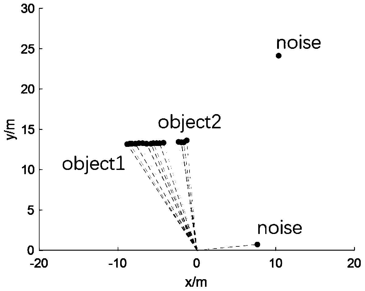
[0046] Step 2: After filtering invalid point clouds, use the DBSCAN algorithm for point cloud clustering;

[0047] Step 3: Use the nearest neighbor data association method to perform inter-frame data matching;

[0048] Step 4: Under the framework of the linear Kalman filter, use the interactive multi-model to estimate the state of the moving target, and adjust the process noise covariance matrix adaptively according to the maneuverability of the target.

Embodiment 2

[0050] In this embodiment, the laser radar in the first step is a Lase-2000D laser radar.

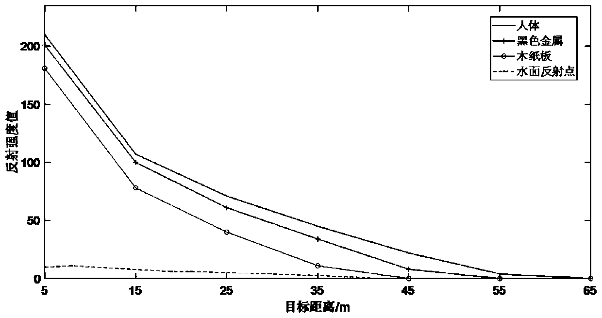
[0051] In this embodiment, the test under the real scene in the step 1 includes selecting the surface of the human body, ferrous metal, and wooden cardboard under the outdoor natural light environment on land for measurement, and the measurement distance is 5-65 meters, once every 10 meters, and It is obtained that the reflection intensity value below 10 is regarded as an invalid point cloud.

[0052] In this embodiment, the parameters that affect the segmentation result in step 2 are the neighborhood range ε ​​and the number of samples in the neighborhood minpts, and the arc length 1 of equidistant adjacent points is used as a reference to set the segmentation parameters. The formula for the segmentation parameters is:

[0053]

[0054] where d is the linear distance from the target to the lidar, and σ is the horizontal resolution of the lidar.

[0055] In this embodiment, in the s...

Embodiment 3

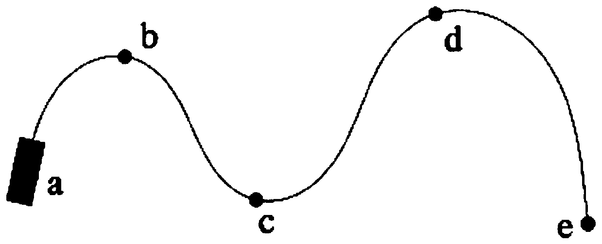
[0071] In order to verify the rationality of parameter selection, a simulation experiment is designed in a uniformly variable speed scenario, and the target speed is considered to be 1m / s and 25m / s respectively. image 3 Driving with variable speed in the path c shown, the result is as follows:

[0072] (a) is Q=0.05I 2*2 Due to the improvement of the trust degree of the observation model, the speed estimation results can be quickly updated to the actual speed of the target near the path points b and c where the target acceleration and heading change, although there is a A few frames of data with large errors, but the overall speed estimate is relatively accurate. However, in terms of heading estimation, since the speed of the target at waypoint b is only 1m / s, there is a large error in the results around the 200th frame, which is consistent with the conclusion of the previous simulation experiment. As the value increases, the heading estimation results are more accurate.

...


PUM


Abstract

The invention relates to the technical field of unmanned surface vehicle environment sensing, in particular to an unmanned surface vehicle environment sensing method based on a single-line laser radar. For the near-distance obstacle avoidance requirement of a small-sized high-speed unmanned surface vehicle during autonomous sailing, invalid echoes of the water surface are filtered according to thepoint cloud reflection intensity in the detection step; DBSCAN clustering parameters are adjusted according to an obstacle distance; inter-frame data matching is performed by adopting a nearest neighbor data correlation method in the tracking step; motion state estimation is performed by using interactive multiple models under a linear Kalman filter framework; and a noise covariance matrix methodis adaptively adjusted according to the maneuverability of targets so as to enhance the adaptability of a filter. According to the method, the detection and tracking within a 40-meter range can be well completed in a low-sea condition scene; the laser radar almost does not cause leak detection in an environment free of wind waves and where the unmanned surface vehicle stably runs; the clusteringerror rate is relatively low in the point cloud clustering and target correlation problems; and the inter-frame targets can be well matched.

Description

technical field [0001] The invention relates to the technical field of unmanned boat environment perception, in particular to an unmanned boat environment perception method based on a single-line laser radar. Background technique [0002] As a surface platform that can independently complete navigation, obstacle avoidance and task execution, unmanned boats can be equipped with different sensors and equipment to complete different mission functions. A major trend in the development of human boats. Due to the small operating radius and high speed of small unmanned boats, the detection and tracking technology of short-distance moving targets is particularly important, which is directly related to its operational safety and the effectiveness of task execution. [0003] The sensors used for water surface environment perception carried by unmanned boats can be divided into two categories: radar and vision sensors. For the short-distance environment perception of small unmanned b...

Claims


Application Information

Patent Timeline
IPC IPC(8): G01S17/88G01S17/06G06K9/62
CPCG01S17/88G01S17/06G01S17/93G01S17/58G06F18/23
Inventor 周治国
Owner BEIJING INSTITUTE OF TECHNOLOGYGY
Why Eureka
Try Eureka