Hypergraph platform-based intelligent statistical method for important crossing of power transmission line
A power transmission line and crossover technology, which is applied in calculation, electrical digital data processing, special data processing applications, etc., can solve problems such as untimely updates, manual statistical errors and omissions, etc., to improve timeliness and accuracy, reduce manpower, etc. The workload, the effect of good promotion and application value
- Summary
- Abstract
- Description
- Claims
- Application Information
AI Technical Summary
Problems solved by technology
Method used
Image
Examples
Embodiment 1
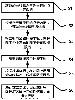
[0048] An intelligent statistical method for important intersections and spans of transmission lines based on a hypergraph platform, comprising the following steps:
[0049] S1: Obtain the point cloud data of the transmission line with three-dimensional coordinates;
[0050] S2: According to the point cloud data containing three-dimensional coordinates, extract the coordinates of transmission line towers;
[0051] S3: According to the coordinates of transmission line towers, publish map services and data services on the SuperMap platform;
[0052] S4: Obtain the coordinates of the tower in the data service;
[0053] S5: According to the coordinates of the tower, display the line drawing of each section of the tower section of the transmission line on the map;
[0054] S6: Perform data comparison, automatically count the information of the crossed objects in each section of the tower section, and output it as a table.
[0055] In step S1, the original point cloud data and IMU ...
Embodiment 2
[0076] An intelligent statistical method for important intersections and crossings of transmission lines based on the HyperMap platform, through unmanned aerial vehicle equipped with laser radar, ground-based radar, vehicle-mounted radar and other technical means, conduct three-dimensional high-precision laser modeling of transmission lines, and obtain laser point clouds of transmission lines data. High-precision lidar uses the principle of laser ranging and photogrammetry to quickly obtain three-dimensional data on the surface of large-scale transmission lines and channels, and can quickly generate digital elevation models, digital surface models and digital orthophotos, and restore lines and corridors with high precision.
[0077] After the lidar outdoor modeling work is completed, the point cloud data containing coordinates is obtained, and the spatial three-dimensional laser point cloud model corresponding to the actual tower spatial position is established. The first posi...
Embodiment 3
[0083] Table 1 is an example of extracting the precise coordinates of transmission line towers through laser point cloud data:
[0084] Table 1 Example table of precise coordinates of transmission line towers
[0085]
PUM
 Abstract
Description
Claims
Application Information
 - R&D
- Intellectual Property
- Life Sciences
- Materials
- Tech Scout
- Unparalleled Data Quality
- Higher Quality Content
- 60% Fewer Hallucinations
Browse by: Latest US Patents, China's latest patents, Technical Efficacy Thesaurus, Application Domain, Technology Topic, Popular Technical Reports.
© 2025 PatSnap. All rights reserved.Legal|Privacy policy|Modern Slavery Act Transparency Statement|Sitemap|About US| Contact US: help@patsnap.com


