Computer vision based land surface settlement monitoring method

A computer vision, surface subsidence technology, applied in computer vision technology, image processing, optics field, can solve problems such as the lack of advantages of the total station, the high price of the total station, and the inability to be effectively competent, and achieve a wide range of scene adaptability, high Scalability and flexibility, fast and efficient installation

Inactive Publication Date: 2019-11-05
ZHEJIANG UNIV
View PDF3 Cites 5 Cited by
  • Summary
  • Abstract
  • Description
  • Claims
  • Application Information

AI Technical Summary

Problems solved by technology

This method needs to scan the monitoring points one by one, the monitoring frequency is limited, and the total station that can automatically scan is more expensive, and the total station that cannot automatically scan has little advantage compared with the level
[0008] The above methods have their own shortcomings, and cannot effectively perform the task of long-term, high-precision, and low-cost monitoring of land surface subsidence in a complex urban environment.

Method used


Image

  • Computer vision based land surface settlement monitoring method
  • Computer vision based land surface settlement monitoring method

Examples


Embodiment Construction

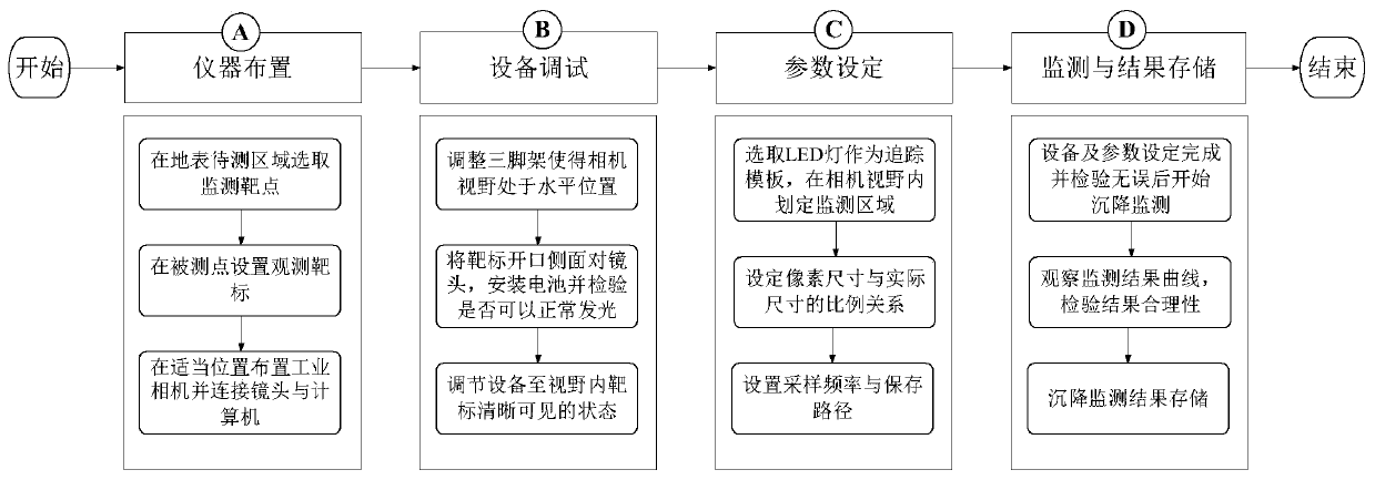
[0057]combine figure 1 The scenario shown and figure 2 The monitoring process shown illustrates the implementation of the present invention in detail.

[0058] see figure 1 and figure 2 , the case cited in the present invention is the process of utilizing an industrial camera and corresponding targets to monitor the surface subsidence of an area, and the specific implementation steps are as follows:

[0059] A. Instrument layout.

[0060] A1. Investigate the surface conditions of the area to be tested, comprehensively consider the surface soil quality and pavement, surrounding roads, vegetation conditions and corresponding monitoring requirements, and select appropriate surface monitoring points6;

[0061] A2. Insert the monitoring target 13 into the ground 12 of the point 6 to be measured to ensure that the target 13 is installed firmly, not loose, and not tilted; each monitoring target 13 consists of a top LED light 7, a top light chamber 10, a rechargeable battery 8, ...


PUM


Abstract

A computer vision based land surface settlement monitoring method comprises the following steps of A) instrument arranging, B) equipment debugging, C) parameter setting and D) monitoring and result storing. Before start of monitoring, a first frame of image is captured, an LED lamp is marked and serves as a tracking template, the pixel center of a template area serves as a reference point for calculating settlement of the point, and a monitoring area of the point is marked according to the pre-estimated settlement; after start of monitoring, a monitoring area of a second frame of image is searched for optimal match of the LED lamp template, a pixel displacement difference is calculated from the pixel center position of the first frame of template area and the pixel center position of the template area obtained by matching in the present frame, and the second frame of image is updated as a new reference point; the pixel displacement difference of the LED lamp template between two adjacent frames of images are calculated repeatedly in the above way; and pixel displacement of the LED lamp is calculated by accumulation of the pixel displacement differences, and a practical settlement process of the LED lamp is calculated by proportional relation between the practical size and the pixel size.

Description

technical field [0001] The invention relates to optics, computer vision technology and image processing technology, in particular to long-term on-line monitoring of land surface subsidence using cameras. Background technique [0002] With the continuous improvement of my country's economic development level, the construction of underground space is booming to meet people's production and living needs in terms of transportation and travel. However, the construction of underground space, including subway shield tunnel construction and foundation pit excavation construction, will cause soil disturbance and cause the surrounding surface to settle, bringing safety hazards to surrounding buildings, pipelines and road surfaces. Therefore, timely monitoring of the ground surface around the underground space construction site is helpful to grasp the development law and degree of its settlement, adjust construction parameters in time, and reduce the impact of underground space constru...

Claims


Application Information

Patent Timeline
Patent Type & Authority Applications(China)
IPC IPC(8): G01C5/00G01C11/00
CPCG01C5/00G01C11/00G01C15/006G01C3/02G01C15/06
Inventor 叶肖伟金涛昂鹏鹏
Owner ZHEJIANG UNIV
Why Eureka
Try Eureka