
A gis-based method for delineating urban and rural space partitions with multiple plans

An analysis method and space technology, applied in data processing applications, forecasting, instruments, etc., can solve problems such as unsatisfactory, improve the accuracy of analysis, ensure accuracy and reference value, and improve the effect of production optimization

Active Publication Date: 2022-02-01
LUOYANG URBAN PLANNING & ARCHITECTURE DESIGN RES INST CO LTD
View PDF5 Cites 0 Cited by
  • Summary
  • Abstract
  • Description
  • Claims
  • Application Information

AI Technical Summary

Problems solved by technology

[0004] The traditional urban and rural planning method only considers a single factor. If it is multi-factor, it generally only considers a small number of factors such as terrain conditions and ecological conditions. When evaluating, it usually uses the evaluation method of weighting and summing multiple factors. However, due to research The ecological sensitivity of each factor in the region is different to a certain extent. This method will lead to the offset or amplification of the evaluation results of single factors to a certain extent, thus affecting the urban spatial division delineated by the evaluation results of regional comprehensive ecological sensitivity. There is no way to meet the country's "multi-plan integration" policy planning and development requirements

Method used


Image

  • A gis-based method for delineating urban and rural space partitions with multiple plans
  • A gis-based method for delineating urban and rural space partitions with multiple plans
  • A gis-based method for delineating urban and rural space partitions with multiple plans

Examples


Embodiment Construction

[0032] The present invention will be described in detail below in conjunction with the accompanying drawings.

[0033] Such as Figure 1-7 Shown:

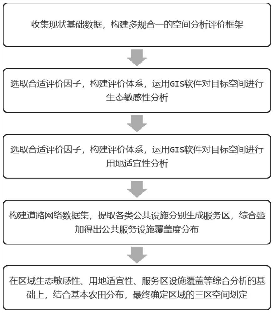
[0034] A method for delineating urban and rural spatial divisions based on GIS, comprising the following steps:

[0035] (1) Collect basic data on the status quo of the target city, and construct a spatial analysis and evaluation framework based on three parts: ecological sensitivity, land use suitability, and facility coverage;

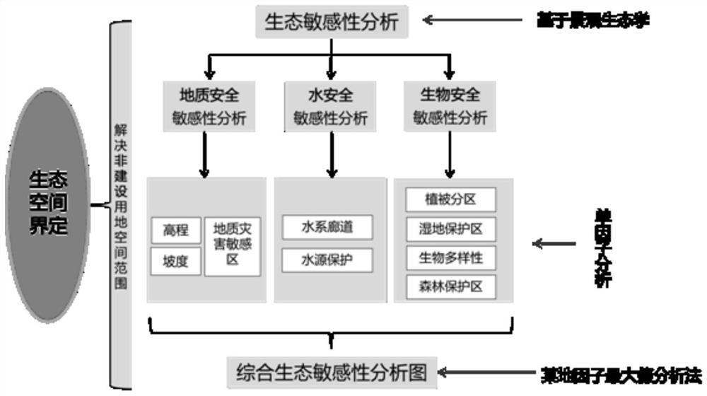
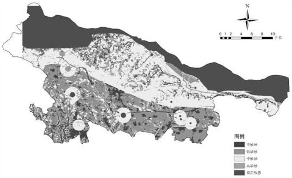
[0036] (2) Using the function of GIS space overlay analysis, select evaluation factors, component evaluation grading system, and carry out ecological sensitivity evaluation analysis on the target urban and rural space according to the selected analysis method;

[0037] (3) Use the function of GIS space overlay analysis, select evaluation factors, component evaluation and grading system, and carry out land use suitability evaluation and analysis on the target urban and rural space according to the select...


PUM


Abstract

The present invention provides a method for delineating urban and rural space partitions based on GIS with multi-planning integration. Based on geographic information systems, a method for delineating urban and rural space partitions using geographic information software for multi-planning integration is proposed. The specific steps include: Collect current data, build an analysis and evaluation framework, use the functions of GIS software space overlay analysis and network analysis, and analyze the ecological sensitivity, land suitability, service area facility coverage, etc. of the region, and finally obtain the ecological bottom line of the region through comprehensive overlay analysis Three-zone spatial delineation of space, construction land space, and agricultural production space. The invention is mainly used to solve the deficiency that the traditional space demarcation method cannot meet the current planning and development requirements, and is innovative, scientific and operable. The beneficial effect of the invention is that the urban and rural space can be distinguished and demarcated rationally, and production, living and ecological spaces with reasonable structure can be divided.

Description

technical field [0001] The invention belongs to the field of urban planning, and in particular relates to a GIS-based method for delimiting urban and rural space partitions with multiple plans integrated into one. Background technique [0002] The GIS usually referred to in the current work is geographic information software, which can be an important part of geographic information systems, and has five major functions: data input and editing, data storage and management, spatial query and analysis, spatial decision support, data display and Output, at present, this technology is mainly used in urban and rural planning, disaster monitoring and rescue, urban construction, transportation construction, environmental management, etc. [0003] During the development and transformation of society, my country has formed a set of distinctive spatial planning system, forming national economic and social development planning, urban and rural planning, overall land use planning, enviro...

Claims


Application Information

Patent Timeline
Patent Type & Authority Patents(China)
IPC IPC(8): G06Q10/04G06Q10/06G06Q50/06
CPCG06Q10/043G06Q10/06393G06Q50/06
Inventor 高屹李璐胡后亮姚光远马世文王璐张寒
Owner LUOYANG URBAN PLANNING & ARCHITECTURE DESIGN RES INST CO LTD
Learn More