Three-dimensional geographic information model data processing system

A technology of geographic information and model data, applied in the field of geographic information, can solve problems such as reducing storage space, reduce the use of disk space, improve efficiency, and simplify the post-processing process.

Pending Publication Date: 2019-08-23
江苏汉盛知识产权运营有限公司
View PDF6 Cites 0 Cited by
  • Summary
  • Abstract
  • Description
  • Claims
  • Application Information

AI Technical Summary

Problems solved by technology

[0004] At present, there is no 3D model data processing system that can effectively automatically process a large amount of 3D geographic information in the process of building a 3D model, merge and simplify the 3D geographic information, and save time and human resources; There is no perfect method that can solve data scheduling and management based on geographic information at the same time, make the use of hardware resources more effective, reduce storage space, simplify models, ensure that models can be displayed quickly, and effectively reduce errors caused by manual operations

Method used


Image

  • Three-dimensional geographic information model data processing system

Examples


Embodiment 1

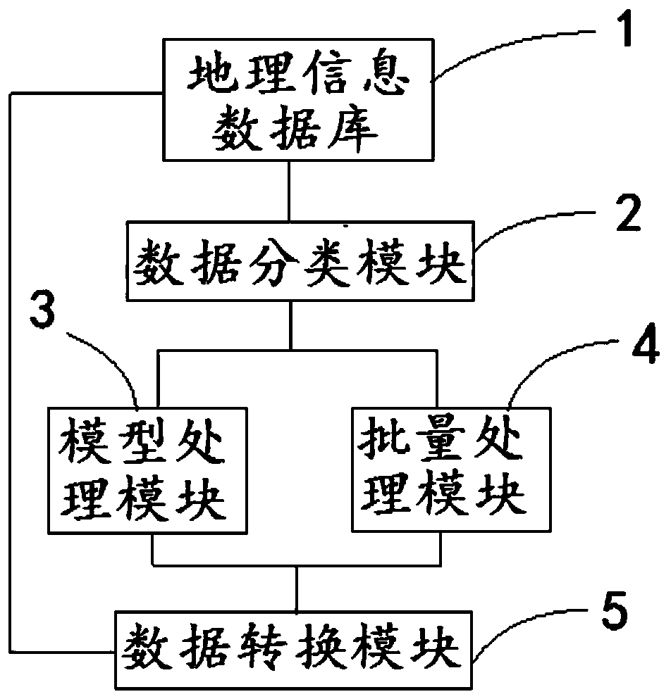
[0039] A three-dimensional geographic information model data processing system, comprising:

[0040] Geographical information database 1, for storing three-dimensional entity object, described three-dimensional entity object comprises geographic information vector data and attribute feature;

[0041] The data classification module 2 is used to classify the three-dimensional entity objects with the same attribute characteristics, which specifically includes: presetting the various attribute characteristics of the geographic information vector data according to the requirements in the model processing, and according to different requirements. Each attribute feature is selected, and after the set attribute feature is processed by default value, the preset three-dimensional model processing parameter information is sent to the batch processing module 4;

[0042] The model processing module 3 is used to separate and simplify the texture processing of the model resources of each thr...

Embodiment 2

[0048] On the basis of the first embodiment, in the second embodiment, the step of classifying the three-dimensional entity objects with the same attribute characteristics may specifically be:

[0049] Classify the geographical information vector data according to the features of the ground and landform;

[0050] The divided geographic information vector data is divided according to different attribute characteristics.

[0051] The 3D model processing parameter information specifically includes: model resources, coordinate resources, texture resources, attribute properties, grid indexes, and 3D entity object indexes for parameter setting or setting multiple parameters according to requirements.

[0052] Therefore, the three-dimensional solid objects can be classified, so that the data can be regularized, which simplifies the later data processing process.

Embodiment 3

[0054] On the basis of Embodiments 1 and 2, in Embodiment 3, texture separation and simplification are performed on the model resources of each three-dimensional entity object, and the model resources, texture resources, and attribute data are sent to the batch processing module 4. The specific steps are:

[0055] Extract geographic information vector data and attribute features of each 3D solid object;

[0056] Converting geographic information vector data into a resource format supported by the three-dimensional data rendering module;

[0057] Separate texture resources from geographic information vector data;

[0058] Simplify the geographic information vector data and its texture resources;

[0059] Compress the original model and its texture and the simplified model and its texture;

[0060] The original model and its texture and the simplified model and its texture are stored separately, and the same model and texture are only stored once;

[0061] Stores attribute c...


PUM


Abstract

The three-dimensional geographic information model data processing system comprises a geographic information database; a data classification module which is used for classifying the three-dimensionalentity objects with the same attribute characteristics; a model processing module which is used for performing texture separation processing and simplification processing on the model resources of each three-dimensional entity object, and sending the model resources, the texture resources and the attribute data to the batch processing module; the batch processing module which is used for setting apath of a three-dimensional entity object and a storage path of a file in a three-dimensional model construction process, performing batch processing setting on a three-dimensional entity object range needing to be processed, and performing batch processing according to the parameter information of the data classification module; and a data conversion module which is used for carrying out batch format setting and batch conversion on the three-dimensional model data processed by the batch processing module, outputting the data and storing the data in a geographic information database. According to the scheme, automatic execution can be achieved, and errors caused by manual operation are effectively reduced.

Description

technical field [0001] The present invention relates to the field of geographic information, and more particularly relates to a three-dimensional geographic information model data processing system. Background technique [0002] With the miniaturization of computers, running 3D models on personal desktops and laptops has become an important means to help the industry grow rapidly. How to effectively dispatch and manage these 3D geographic information models has become the focus of research. [0003] At present, computers cannot load massive amounts of data at one time, and dynamic scheduling technology must be used to realize roaming and application of large-scale 3D scenes, and dynamically load 3D models within a certain range as the viewpoint moves. Some scholars have discussed the dynamic scheduling technology and achieved many results. However, how to apply this technology deeply in the construction and management of massive 3D digital cities, and how to realize fast a...

Claims


Application Information

Patent Timeline
IPC IPC(8): G06F16/29G06T17/05
CPCG06F16/29G06T17/05
Inventor 纪学超高飞飞顾宝州张静
Owner 江苏汉盛知识产权运营有限公司
Why Eureka
Try Eureka