High-precision electronic map navigation method and device
A technology of electronic map and navigation method, which is applied in directions such as navigation, measuring device, surveying and mapping, and navigation, can solve the problem of not displaying high-precision electronic map navigation, etc., and achieve the effect of high-precision navigation
- Summary
- Abstract
- Description
- Claims
- Application Information
AI Technical Summary
Problems solved by technology
Method used
Image

Examples
Embodiment 1
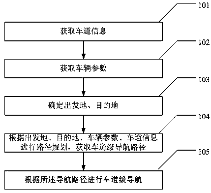
[0029] Such as figure 1 As shown, the embodiment of the present invention provides a high-precision electronic map navigation method, including the following steps:
[0030] 101. Acquire lane information; the lane information includes at least one of the following information: lane position, lane length, lane width, lane shape, lane line shape, lane line position, lane line attributes (such as dashed lines, solid lines, double yellow lines, etc.) , lane direction, lane attributes (such as bus lanes, truck lanes, lane restriction information, etc.), or lane conditions (such as congestion, slowing, smooth, etc.).
[0031] Lane position, lane length, lane width, lane shape, lane line shape, lane line position, lane line attributes (such as dashed lines, solid lines, double yellow lines, etc.), lane direction, lane attributes (such as bus lanes, truck lanes, Lane restriction information, etc.) can be collected on the spot by using laser point cloud technology, and the road cond...
Embodiment 2
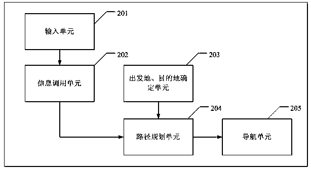
[0037] The embodiment of the present invention also provides a high-precision electronic map navigation device, including:
[0038] The input unit 201 is configured to receive an operation instruction from a user.
[0039] The information calling unit 202 is used to call lane information and vehicle parameters. The vehicle parameters are input by the user through the input unit 201 and stored in the navigation device or a server communicated with the navigation device, and the vehicle parameters include at least one of the following information: vehicle length, vehicle height, vehicle weight or vehicle type (such as cars, trucks, buses, etc.). The lane information is pre-stored in the navigation device or a server connected to the navigation device by a high-precision electronic map service provider, and the lane information includes at least one of the following information: lane position, lane length, lane width , lane shape, lane line shape, lane line position, lane line ...
PUM
 Abstract
Description
Claims
Application Information
 - Generate Ideas
- Intellectual Property
- Life Sciences
- Materials
- Tech Scout
- Unparalleled Data Quality
- Higher Quality Content
- 60% Fewer Hallucinations
Browse by: Latest US Patents, China's latest patents, Technical Efficacy Thesaurus, Application Domain, Technology Topic, Popular Technical Reports.
© 2025 PatSnap. All rights reserved.Legal|Privacy policy|Modern Slavery Act Transparency Statement|Sitemap|About US| Contact US: help@patsnap.com