
Road state updating method and system of electronic map and storage medium

A road status and electronic map technology, applied in geographic information databases, data processing applications, structured data retrieval, etc., can solve problems such as heavy workload, long issuance cycle of navigation electronic maps, and status cannot be restored in time, so as to avoid Limitations, the effect of optimizing the high-level road network

Active Publication Date: 2019-07-19
丰图科技(深圳)有限公司
View PDF5 Cites 8 Cited by
  • Summary
  • Abstract
  • Description
  • Claims
  • Application Information

AI Technical Summary

Problems solved by technology

[0003] Navigation electronic maps have a long release cycle (usually updated quarterly). From the perspective of information collection and data production updates, the status of roads under construction and construction roads in the map cannot be restored in time
According to customer feedback, the operators open the road and upgrade the FC of the associated road network to repair the high-level road network. The workload is heavy and there are limitations.

Method used


Image

  • Road state updating method and system of electronic map and storage medium
  • Road state updating method and system of electronic map and storage medium

Examples


Embodiment Construction

[0050] The specific embodiments of the present invention are used to illustrate the present invention, but are not limited to the specific embodiments.

[0051] Floating vehicles generally refer to vehicles such as buses and taxis that are equipped with vehicle-mounted GPS positioning devices and drive on urban arterial roads. According to the vehicle position, direction and speed information regularly recorded by the floating vehicle equipped with the vehicle-mounted global positioning system during its driving process, the relevant calculation models and algorithms such as map matching and path estimation are used for processing, so that the floating vehicle position data and urban roads Time and space are correlated, and traffic congestion information such as the vehicle speed of the road that the floating car passes and the travel time of the road are finally obtained.

[0052] The invention utilizes the characteristics of the floating car to provide a method capable of up...


PUM


Abstract

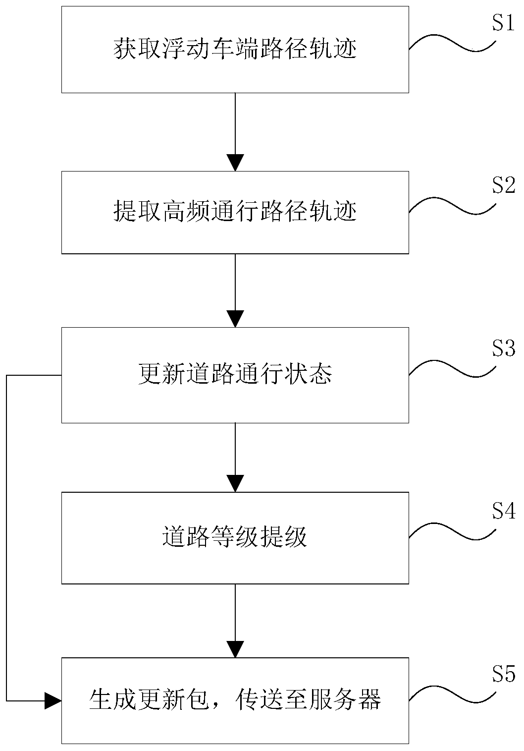
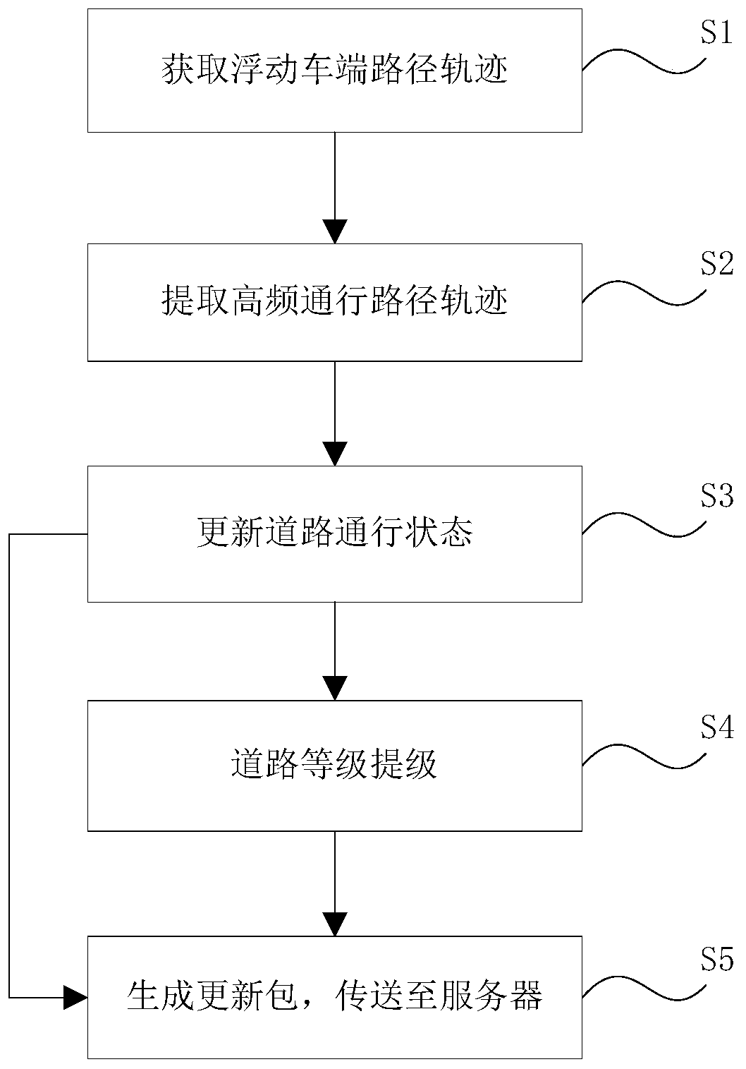
The invention provides a road state updating method of an electronic map. The road state updating method comprises the following steps: acquiring a floating vehicle end path track; extracting an effective path track segment to be matched with a road in an electronic map, recording matched path information, and extracting a high-frequency passing path track; updating the road state of the high-frequency passing path track of the to-be-built road or the constructed road into a passable state; and generating an update package, and transmitting the update package to the electronic map server. According to the invention, the authenticity and timeliness of the open state of the built road or the constructed road of the electronic map avoid the limitation of human subjective judgment; based on the method, the shortest and optimal high-frequency passing experience path is recommended to the high-rise road network, and the high-rise road network is optimized.

Description

technical field [0001] The invention relates to the technical field of electronic maps. Background technique [0002] The route planning in the navigation electronic map is based on the multi-level road network for route exploration, and the multi-level road network is derived from the upgrade of the lowest road level FC. In reality, roads under construction and roads under construction are impassable roads. If the road under construction or road under construction resumes traffic, but the navigation electronic map is not updated in time, there are still detours planned for the road under construction or under construction during route planning, and the travel distance and time will increase, resulting in poor customer experience. [0003] The release cycle of navigation electronic maps is long (usually updated on a quarterly basis). From the perspective of information collection and data production and update, the status of roads under construction and construction roads i...

Claims


Application Information

Patent Timeline
Patent Type & Authority Applications(China)
IPC IPC(8): G06F8/65G06F16/29G06Q10/04
CPCG06F8/65G06F16/29G06Q10/047
Inventor 段晓军
Owner 丰图科技(深圳)有限公司
Learn More