
Satellite selection optimized advanced receiver autonomous integrity monitoring method

An integrity monitoring and receiver technology, applied in the field of satellite navigation, can solve problems such as descent, and achieve the effect of simplifying complexity, reducing difficulty and calculation amount, and improving usability

Active Publication Date: 2019-07-12
NANJING UNIV OF AERONAUTICS & ASTRONAUTICS
View PDF8 Cites 11 Cited by
  • Summary
  • Abstract
  • Description
  • Claims
  • Application Information

AI Technical Summary

Problems solved by technology

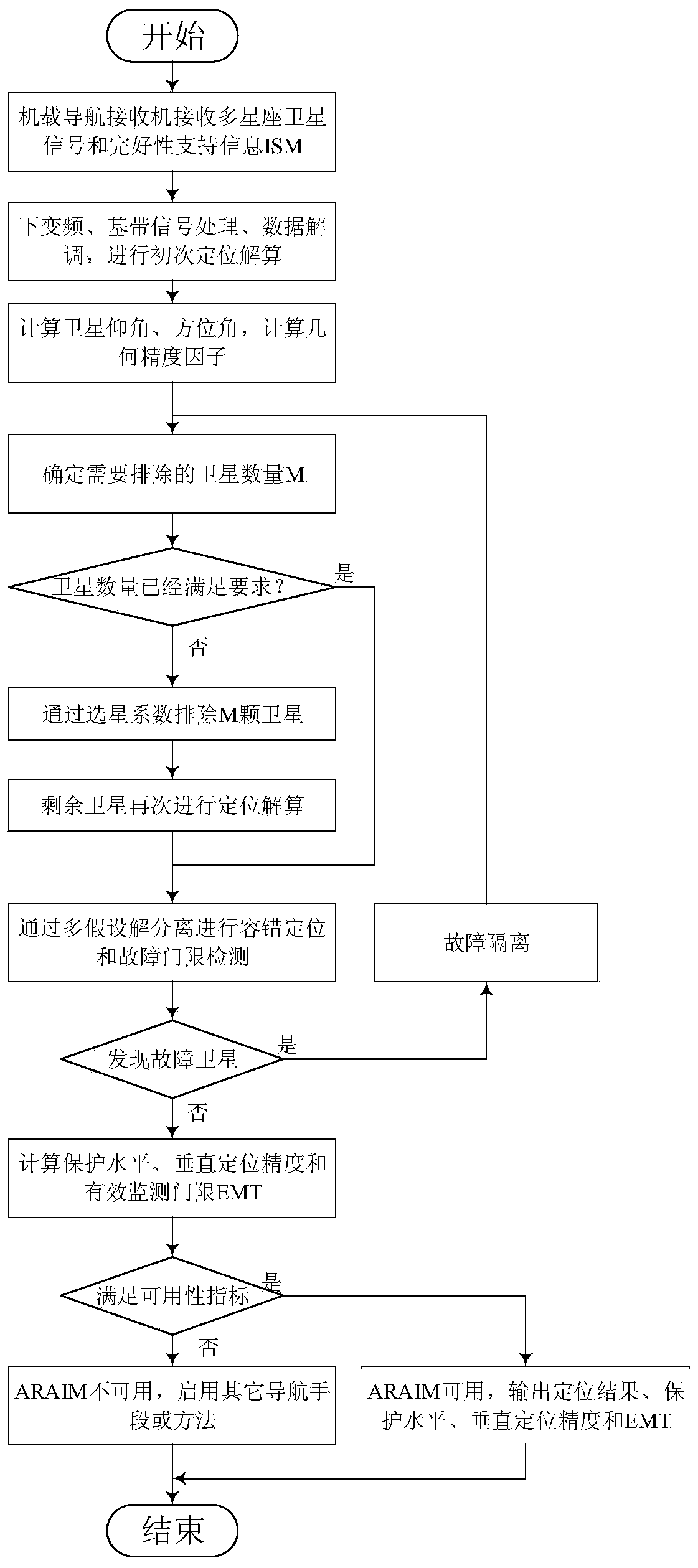
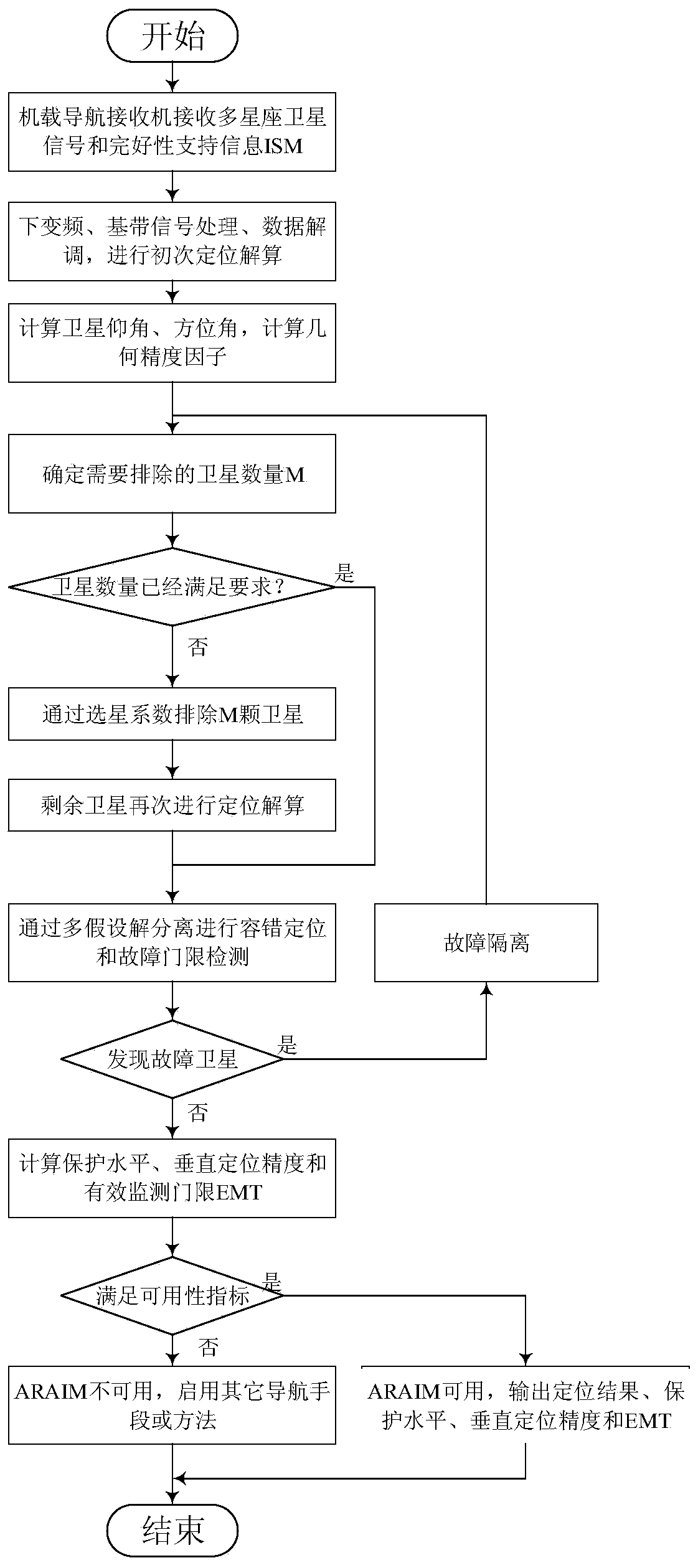
[0009] The technical problem to be solved by the present invention is: ARAIM provides higher positioning accuracy and stricter integrity level by receiving observations from multi-constellation navigation satellites, but the participation of too many satellites also brings negative effects to the signal processing of ARAIM : On the one hand, the more satellites involved in positioning, the more satellites that may fail, and the number of fault modes that need to be monitored will increase, which increases the computational complexity and amount of calculation in the fault-tolerant positioning stage; on the other hand, monitoring too many faults will easily lead to intact The protection level of permanent monitoring is expanded, which leads to ARAIM not meeting the availability criterion; in addition, satellites with low elevation angles participating in positioning will reduce the consistency of observations, and satellites with a priori high failure probability will increase the probability of failure. The above situations are easy Resulting in decreased ARAIM usability

Method used


Image

  • Satellite selection optimized advanced receiver autonomous integrity monitoring method
  • Satellite selection optimized advanced receiver autonomous integrity monitoring method
  • Satellite selection optimized advanced receiver autonomous integrity monitoring method

Examples


Embodiment Construction

[0037] Below in conjunction with accompanying drawing, the technical scheme of invention is described in detail:

[0038] The overall process of this method is as follows figure 1 shown. The above process needs to complete the following tasks:

[0039]1. Calculation method of spatial geometric distribution matrix

[0040] Satellite spatial geometric distribution matrix G, also known as the Jacobian matrix for receiver positioning solution; the spatial geometric distribution matrix G of the jth satellite navigation system j The calculation method is:

[0041]

[0042] Among them, n indicates that there are n satellites participating in the positioning solution, θ j,k and alpha j,k Indicates the elevation angle and azimuth angle of each satellite, and the subscript (j,k) indicates the kth satellite of the jth satellite navigation system.

[0043] 2. Position estimation method based on weighted least squares

[0044] The traditional ARAIM user algorithm is based on the ...


PUM


Abstract

The invention discloses a satellite selection optimized advanced receiver autonomous integrity monitoring method, and belongs to the technical field of satellite navigation. Advanced receiver autonomous integrity monitoring is a receiver end fault diagnosis and integrity monitoring technology based on a multi-constellation satellite navigation system, ARAIM provides a more strict integrity level by receiving the observed quantity of a multi-constellation satellite, however, due to participation of too many satellites, a fault mode needing to be monitored is increased, and the protection levelis expanded; in addition, the satellite with the large prior fault probability can increase the fault probability. And the ARAIM availability is easily reduced under the condition. According to the ARAIM method based on satellite selection optimization provided by the invention, the space satellite constellation is optimized according to the geometric accuracy factor of the constellation, the fault prior probability of the satellite and the like, the ARAIM availability is improved, and the calculation complexity is simplified. The method is suitable for autonomous integrity monitoring application of the satellite navigation receiver, and the same idea is suitable for other signal systems adopting multi-hypothesis solution separation.

Description

technical field [0001] The invention belongs to the technical field of satellite navigation, in particular to a method for autonomous integrity monitoring of advanced receivers optimized for satellite selection. Background technique [0002] Receiver Autonomous Integrity Monitoring (RAIM) is a method for satellite navigation receivers to independently diagnose and eliminate faults based on redundant GNSS information. The RAIM algorithm is included in the receiver, so it is called autonomous monitoring. RAIM is also the most direct, most timely, most widely used, most deeply researched, and most computationally efficient integrity monitoring method. RAIM technology only supports lateral navigation, and cannot meet the performance requirements of vertical guidance navigation channels below 200 feet (Localized Performance with Vertical guidance, LPV-200) defined by ICAO. Advanced Receiver Autonomous Integrity Monitoring (Advanced RAIM, ARAIM) is a solution designed by the GNSS...

Claims


Application Information

Patent Timeline
Patent Type & Authority Applications(China)
IPC IPC(8): G01S19/20G01S19/23
CPCG01S19/20G01S19/23
Inventor 孟骞曾庆化刘建业许睿曾世杰黄河泽史进恒宦国耀
Owner NANJING UNIV OF AERONAUTICS & ASTRONAUTICS
Learn More