
Positioning method for inhibiting mine non-line-of-sight error

A non-line-of-sight, error-free technology, applied in the fields of radio communication, ranging and positioning, can solve the problems of poor real-time positioning, large amounts of data, and large errors

Active Publication Date: 2019-07-12
CHINA UNIV OF MINING & TECH (BEIJING)
View PDF10 Cites 4 Cited by
  • Summary
  • Abstract
  • Description
  • Claims
  • Application Information

AI Technical Summary

Problems solved by technology

At present, methods such as Kalman filtering are mainly used at home and abroad to reduce the non-line-of-sight positioning error. However, the filtering method requires a large amount of data, the calculation is large, the system burden is heavy, the error after filtering is still large, and the real-time performance is reduced. Difference

Method used


Image

  • Positioning method for inhibiting mine non-line-of-sight error
  • Positioning method for inhibiting mine non-line-of-sight error
  • Positioning method for inhibiting mine non-line-of-sight error

Examples


Embodiment Construction

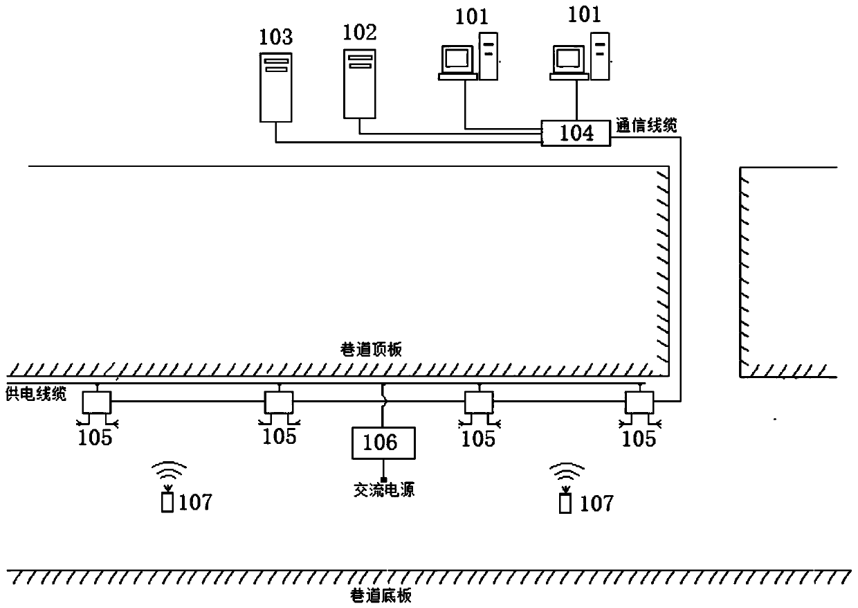
[0022] The method is realized by an underground positioning system, and the underground positioning system is composed as follows figure 1 Shown:

[0023] 1. Monitoring terminal (101), production management personnel access the positioning server through the monitoring terminal to realize real-time monitoring of underground staff and related equipment. The monitoring terminal has map display, staff location and data display query, staff location statistics, historical location Tracking query and other functions.

[0024] 2. The positioning storage server (102), responsible for receiving and storing the positioning card position data sent by the sub-station, and providing retrieval and query services for the GIS server and the monitoring terminal.

[0025] 3. The GIS server (103) is responsible for providing geographical information services for the monitoring terminal, using the ArcGIS platform, and storing relevant geographical information data of the mine, location data of ...


PUM


Abstract

According to the positioning method for inhibiting the mine non-line-of-sight error, personnel, vehicles and the like in a mine can prevent positioning signals from being propagated linearly between apositioning card and substations, non-line-of-sight transmission NLOS such as reflection, diffraction and scattering can be caused, and then the positioning error is caused. According to the characteristics of distance measurement change caused by non-line-of-sight signal intensity attenuation and distance measurement change caused by non-line-of-sight signal time delay; the positioning method for inhibiting the mine non-line-of-sight errors through the multiple parameters of the signal arrival time and the signal strength is invented, signal arrival time and signal strength ranging communication and data processing are carried out at the same time, and accurate positioning is achieved. The method is simple in implementation process, high in positioning speed, high in real-time performance and high in popularization value.

Description

technical field [0001] The invention relates to a positioning method for suppressing non-line-of-sight errors in mines, and the method relates to the fields of radio communication, ranging and positioning technologies and the like. Background technique [0002] The mine personnel positioning system is one of the six safety and risk avoidance systems required by the State Council (Guo Fa [2010] No. 23) for coal mines and non-coal mines. The RFID technology widely used by mine personnel cannot be accurately positioned, and it is difficult to meet the needs of accident prevention and emergency rescue such as searching for people in distress and vehicle injuries in mines. Mine radio signal transmission attenuation is serious, radio transmission attenuation models are complex and changeable, satellite positioning signals cannot penetrate coal seams and rock formations to reach underground, and mine positioning needs to cover 10km roadways, etc., restricting the application of gro...

Claims


Application Information

Patent Timeline
IPC IPC(8): G01S5/06G01S5/02H04W64/00H04B17/318
CPCG01S5/021G01S5/0257G01S5/0278G01S5/06H04W64/006H04B17/318
Inventor 孙继平
Owner CHINA UNIV OF MINING & TECH (BEIJING)
Learn More