
A system and method for extracting plant height based on unmanned aerial vehicle image DSM

A plant height and unmanned aerial vehicle technology, which is applied to computer components, instruments, character and pattern recognition, etc., can solve problems such as high cost, low measurement efficiency, and inability to realize large-scale applications, so as to reduce measurement costs, Accurately Acquired Effects

Pending Publication Date: 2019-06-28
景遥(上海)信息技术有限公司
View PDF4 Cites 4 Cited by
  • Summary
  • Abstract
  • Description
  • Claims
  • Application Information

AI Technical Summary

Problems solved by technology

[0002] In recent years, emerging new technologies have greatly promoted the development of agriculture, forestry and garden informatization, especially the development of UAV low-altitude remote sensing platform, which has greatly improved the means of information acquisition in forestry and garden surveys, but tree High-precision measurement has always been an urgent problem to be solved in agricultural and forestry surveys. Traditional ground measurement methods such as altimeters have low measurement efficiency and cannot be applied on a large scale. Although the new UAV lidar remote sensing method can complete large-scale Tree height measurement, but at a high cost

Method used


Image

  • A system and method for extracting plant height based on unmanned aerial vehicle image DSM
  • A system and method for extracting plant height based on unmanned aerial vehicle image DSM

Examples


Embodiment Construction

[0020] The following will clearly and completely describe the technical solutions in the embodiments of the present invention with reference to the accompanying drawings in the embodiments of the present invention. Obviously, the described embodiments are only some, not all, embodiments of the present invention. Based on the embodiments of the present invention, all other embodiments obtained by persons of ordinary skill in the art without making creative efforts belong to the protection scope of the present invention.

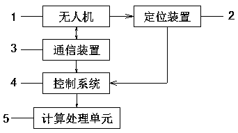
[0021] see Figure 1~2 , in the embodiment of the present invention, the system for extracting plant height based on UAV image DSM includes: UAV 1, positioning device 2, communication device 3, control system 4 and calculation processing unit 5, and the positioning device 2 accesses The Beidou satellite positioning system is used to obtain the latitude and longitude coordinate information of the UAV 1, and the communication device 3 is used for wireless commun...


PUM


Abstract

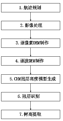
The invention discloses a system and method for extracting plant height based on an unmanned aerial vehicle image DSM. According to the method, based on the DSM (Digital Surface Model) extraction technology of unmanned aerial vehicle photography images, the vegetation height data can be accurately obtained by utilizing digital elevation model extraction of vegetation filtering and vegetation crowntype automatic identification based on computer deep learning, and compared with a laser radar remote measurement mode, the measurement cost is greatly reduced.

Description

technical field [0001] The invention relates to the technical field of ecological environment protection monitoring, in particular to a system and method for extracting plant height based on UAV image DSM. Background technique [0002] In recent years, emerging new technologies have greatly promoted the development of agriculture, forestry and garden informatization, especially the development of UAV low-altitude remote sensing platform, which has greatly improved the means of information acquisition in forestry and garden surveys, but tree High-precision measurement has always been an urgent problem to be solved in agricultural and forestry surveys. Traditional ground measurement methods such as altimeters have low measurement efficiency and cannot be applied on a large scale. Although the new UAV lidar remote sensing method can complete large-scale Tree height measurement, but at a high cost. Contents of the invention [0003] The purpose of the present invention is to ...

Claims


Application Information

Patent Timeline
IPC IPC(8): G06K9/00G06F16/29
Inventor 孟陈李俊祥杨卫军张超吴昊李鸿威
Owner 景遥(上海)信息技术有限公司
Learn More