Intelligent vehicle multi-mode cooperative positioning system, method and intelligent vehicle

A technology for collaborative positioning and intelligent vehicles, applied in satellite radio beacon positioning systems, vehicle components, radio wave measurement systems, etc., can solve problems such as inability to obtain positioning information, achieve real-time performance and reliability, and ensure road traffic safety Effect

Active Publication Date: 2021-04-13
CHANGAN UNIV
View PDF8 Cites 0 Cited by
  • Summary
  • Abstract
  • Description
  • Claims
  • Application Information

AI Technical Summary

Problems solved by technology

[0004] Aiming at the problems existing in the prior art, the present invention provides a smart vehicle multi-mode cooperative positioning system, a method and a smart vehicle, which can solve the problem that positioning information cannot be obtained in GNSS blind areas

Method used


Image

  • Intelligent vehicle multi-mode cooperative positioning system, method and intelligent vehicle
  • Intelligent vehicle multi-mode cooperative positioning system, method and intelligent vehicle
  • Intelligent vehicle multi-mode cooperative positioning system, method and intelligent vehicle

Examples


Embodiment Construction

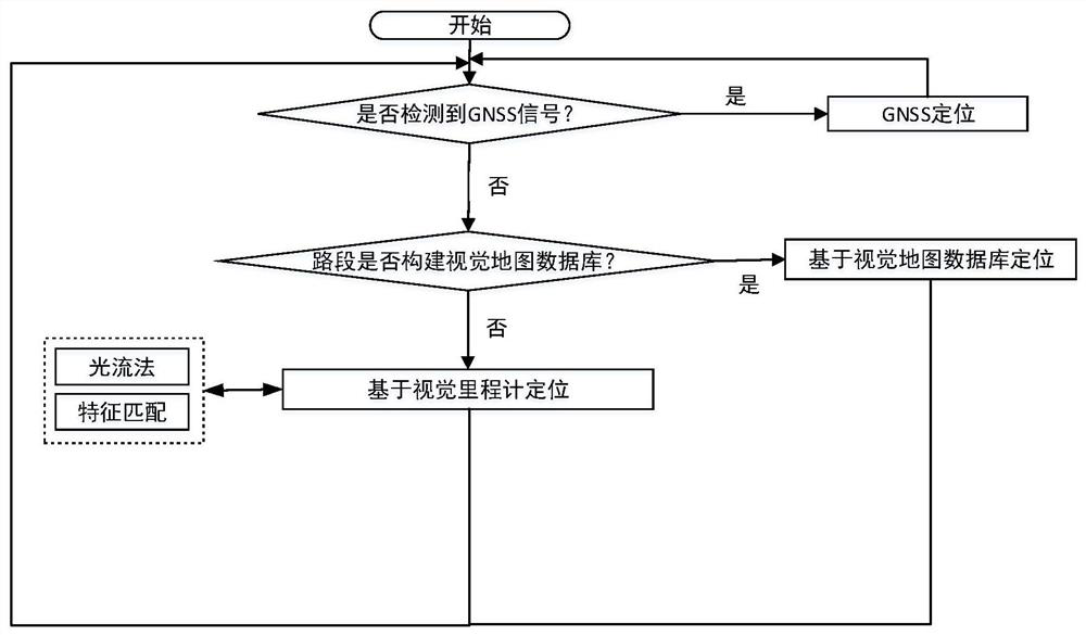
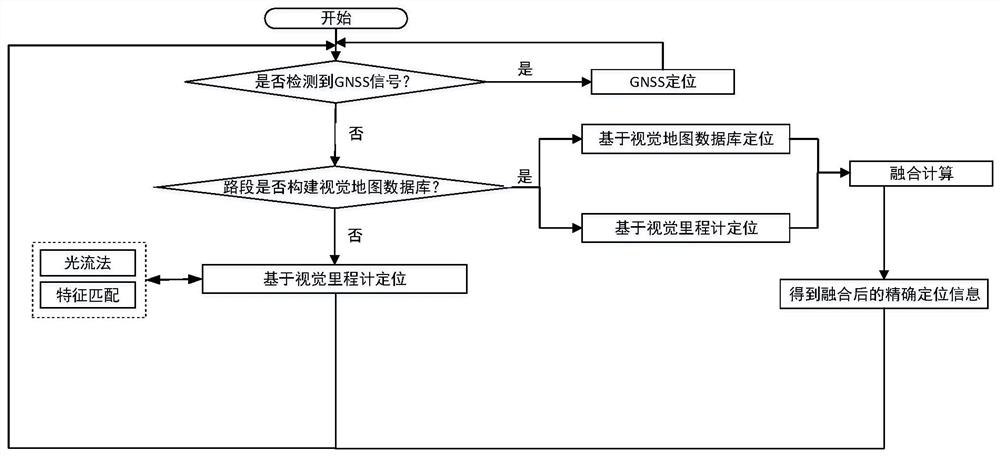
[0036] The present invention will be further described in detail below in conjunction with specific embodiments, which are explanations of the present invention rather than limitations.

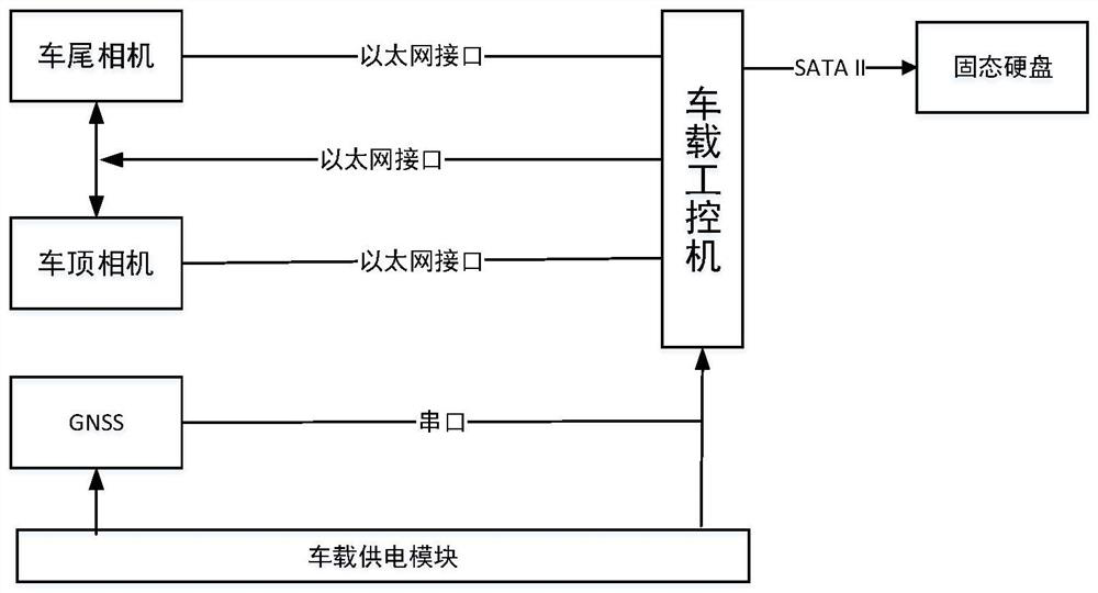
[0037] The intelligent vehicle multi-mode cooperative positioning system of the present invention includes a data acquisition module, a data processing module, a storage module, a power supply module and a communication module.

[0038]The data collection module includes a road surface image collection module, a scene image collection module and a GNSS module; the road surface image collection module is a camera arranged at the rear of the vehicle, which is used to collect the road surface images of the vehicle driving section and sends them to the data processing module; the scene image collection module is The camera installed on the roof is used to collect the scene image of the vehicle driving section and send it to the data processing module; the GNSS module uses GPS, Beidou, GLONASS or G...


PUM


Abstract

The present invention provides a multi-mode collaborative positioning system and method for smart vehicles, which collects road surface images and scene images of vehicle driving sections, and obtains GNSS position information; if the GNSS position information is received, the GNSS position information is used as the positioning information; if the GNSS position information is not received For GNSS position information, check whether the visual map database is pre-established on the road section of the vehicle. If not, use the vehicle positioning technology based on the visual odometer to obtain the position according to the collected road surface image; if yes, use the vehicle positioning technology based on the collected scene image. The vehicle positioning technology based on the visual map database is used for position acquisition; or, the vehicle positioning technology based on the visual map database and the position information obtained by the vehicle positioning technology based on the visual odometer are fused. The invention integrates three positioning technologies, and can well solve the problem that positioning information cannot be obtained in GNSS blind areas.

Description

technical field [0001] The invention belongs to the field of intelligent transportation, in particular to the field of intelligent perception and service of intelligent transportation position information, and relates to a multi-mode cooperative positioning system and method for an intelligent vehicle and an intelligent vehicle. Background technique [0002] In recent years, cars have become an indispensable part of people's lives. However, with the rapid growth of car ownership, road traffic capacity is gradually saturated, which brings a series of problems while greatly facilitating human life, such as Traffic accidents, road jams, etc. The emergence of the concept of Intelligent Transportation System (Intelligent Transportation System, ITS) provides a new idea for solving the above problems. It effectively integrates advanced information, data transmission, electronic sensing, control and computer technologies for the entire ground transportation. It is a real-time, accu...

Claims


Application Information

Patent Timeline
Patent Type & Authority Patents(China)
IPC IPC(8): G01C21/28G01C21/30G01C21/34G01S19/48B60R16/023
Inventor 赵祥模吕洁印周经美程鑫惠飞徐志刚
Owner CHANGAN UNIV
Why Eureka
Try Eureka