Polar-area multi-source information fusion navigation method based on federated filtering

A technology of multi-source information fusion and navigation method, which is applied in the directions of navigation through speed/acceleration measurement, radio wave measurement system, satellite radio beacon positioning system, etc. The actual needs of regional navigation, the impact of system accuracy and reliability, etc., achieve the effect of high engineering application value, easy design and implementation, and high accuracy and reliability.

Inactive Publication Date: 2019-05-10
HARBIN ENG UNIV
View PDF3 Cites 29 Cited by
  • Summary
  • Abstract
  • Description
  • Claims
  • Application Information

AI Technical Summary

Problems solved by technology

[0003] At present, to suppress grid inertial navigation errors and improve navigation accuracy in high-latitude regions, most of them use error suppression methods based on Kalman filter or multi-source information fusion technology of centralized Kalman filter, although the system navigation accuracy has been improved to a certain extent. , but long-term stability and reliability are difficult to guarantee
The combination of grid SINS and DVL can effectively suppress the error of polar inertial navigation, but the positioning error of the combined system still shows a divergent trend; the combination of grid SINS and GNSS can obtain accurate position information and effectively suppress the error of grid inertial navigation system. However, GNSS has obvious multipath effects in high latitude areas and is easily affected by the external environment, which leads to poor quality of satellite positioning signals and affects the accuracy and reliability of the system; therefore, only Kalman filter-based Error suppression methods cannot meet the actual needs of polar region navigation
On the other hand, in the article "Research on Inertial Navigation and Integrated Navigation Algorithms in Polar Regions Based on Grid Coordinate System", Zhao Chenglong adopted the grid inertial navigation / odometer / GNSS centralized filtering navigation method, although higher High-precision navigation performance realizes high-precision polar navigation; however, this method cannot isolate the connection and faults between subsystems, has poor fault tolerance, and cannot guarantee system reliability in extreme environments in polar regions; therefore, centralized Kalman Filtered multi-source information fusion technology cannot meet the actual needs of polar region navigation

Method used


Image

  • Polar-area multi-source information fusion navigation method based on federated filtering
  • Polar-area multi-source information fusion navigation method based on federated filtering
  • Polar-area multi-source information fusion navigation method based on federated filtering

Examples


Embodiment Construction

[0034] The present invention will be further described in detail below in conjunction with the accompanying drawings and specific embodiments.

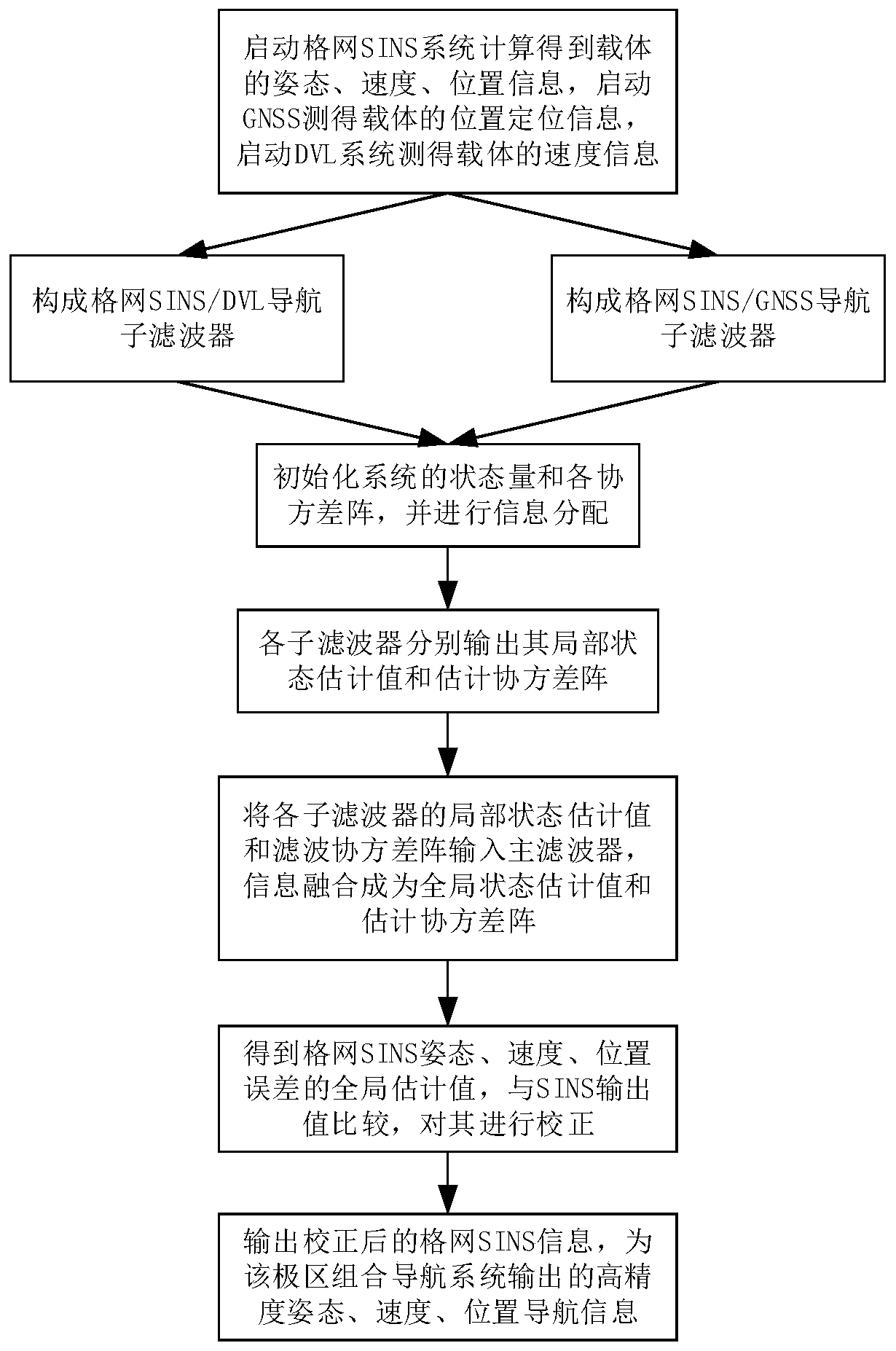
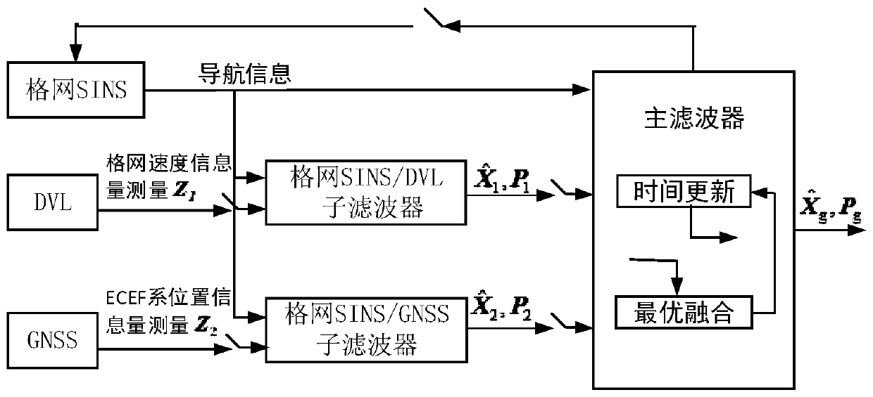
[0035] The present invention proposes a polar region integrated navigation method based on federated filtering, and its system structure is as attached figure 2 As shown, the flow chart is attached figure 1 As shown, the main steps of the method are as follows:

[0036] (1) Run the grid inertial navigation system to output the navigation information of the attitude, speed and position under the grid system, run the DVL log to output the speed information of the carrier, and run the GNSS navigation system to output the positioning information of the carrier under the ECEF system;

[0037] (2) Select polar grid inertial navigation as the main navigation system, establish the error model of grid inertial navigation, and select DVL and GNSS as the auxiliary navigation system;

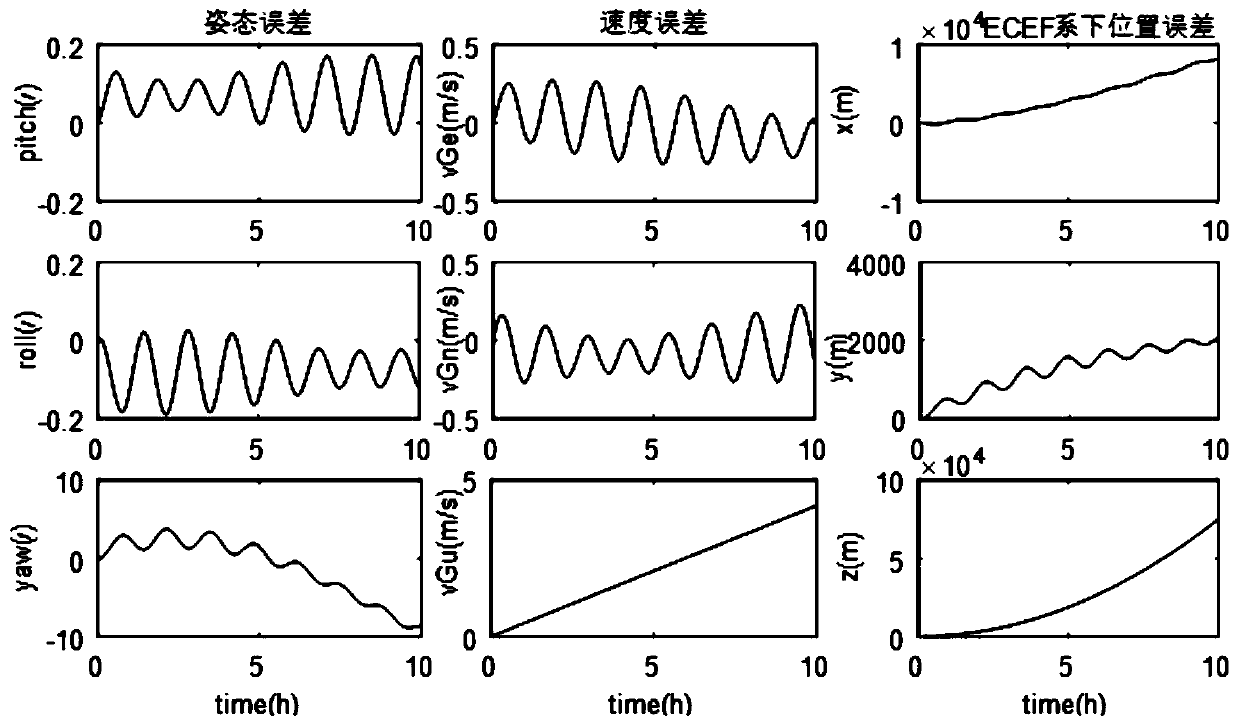
[0038] The grid inertial navigation error model is

[003...


PUM


Abstract

The invention provides a polar-area multi-source information fusion navigation method based on federated filtering. Adopted navigation equipment includes a grid inertial navigation system, a Doppler log and a global satellite positioning system; a multi-source information fusion navigation algorithm based on a non-reset federated filter is designed; simultaneously, high-precision and high-reliability navigation requirements of a polar-area carrier are satisfied; two inertial navigation / Doppler and inertial navigation / satellite sub-filters are established by respectively taking grid system speed information and ECEF system position information as measuration; a local estimation value is calculated through information distribution; information fusion is carried out by inputting into a main filter; and thus, global error estimation of the inertial navigation posture, speed and position is obtained and compensated. According to the polar-area multi-source information fusion navigation method based on federated filtering in the invention, the grid inertial navigation accumulation error is inhibited through inertial navigation / Doppler and inertial navigation / satellite combinations; the system precision is increased; the high fault tolerance also can be realized by utilization of a multi-source information fusion technology based on a non-reset filter; and the purpose of simultaneously realizing the high precision and the high reliability of a polar-area navigation system is achieved.

Description

technical field [0001] The invention relates to a navigation method for improving carrier navigation accuracy and reliability in polar regions, in particular to a multi-source information fusion navigation method based on federated filtering polar region grid SINS / DVL / GNSS combination. Background technique [0002] In order to solve the problem of positioning and orientation caused by the convergence of meridians in high-latitude areas in the polar region, the grid navigation coordinate system is often used with the polar region inertial navigation system as the main navigation equipment for the polar region carrier. Similar to the conventional north-pointing inertial navigation system, the grid inertial navigation system also has errors that gradually accumulate with time and various inherent periodic oscillation errors. It cannot be used alone for a long time, and it needs to be combined with other navigation equipment to use information fusion. Technology to suppress navi...

Claims


Application Information

Patent Timeline
IPC IPC(8): G01C21/16G01S19/47
Inventor 许兆新范睿恒程建华康瑛瑶秦名赫
Owner HARBIN ENG UNIV
Why Eureka
Try Eureka