
A remote sensing video satellite image processing method and system based on image stabilization

A technology of satellite image and processing method, which is applied in the field of satellite remote sensing and video application, and can solve problems such as unremoved frame-to-frame jitter

Inactive Publication Date: 2019-05-03
SPACE STAR TECH CO LTD
View PDF6 Cites 7 Cited by
  • Summary
  • Abstract
  • Description
  • Claims
  • Application Information

AI Technical Summary

Problems solved by technology

At present, remote sensing video satellites only do geometric correction, and the inter-frame jitter is not eliminated for video products.

Method used


Image

  • A remote sensing video satellite image processing method and system based on image stabilization
  • A remote sensing video satellite image processing method and system based on image stabilization
  • A remote sensing video satellite image processing method and system based on image stabilization

Examples


Embodiment Construction

[0023] Exemplary embodiments of the present disclosure will be described in more detail below with reference to the accompanying drawings. Although exemplary embodiments of the present disclosure are shown in the drawings, it should be understood that the present disclosure may be embodied in various forms and should not be limited by the embodiments set forth herein. Rather, these embodiments are provided for more thorough understanding of the present disclosure and to fully convey the scope of the present disclosure to those skilled in the art. It should be noted that, in the case of no conflict, the embodiments of the present invention and the features in the embodiments can be combined with each other. The present invention will be described in detail below with reference to the accompanying drawings and examples.

[0024] In the process of traditional remote sensing video processing, according to the characteristics of small video satellites and remote sensing satellites...


PUM


Abstract

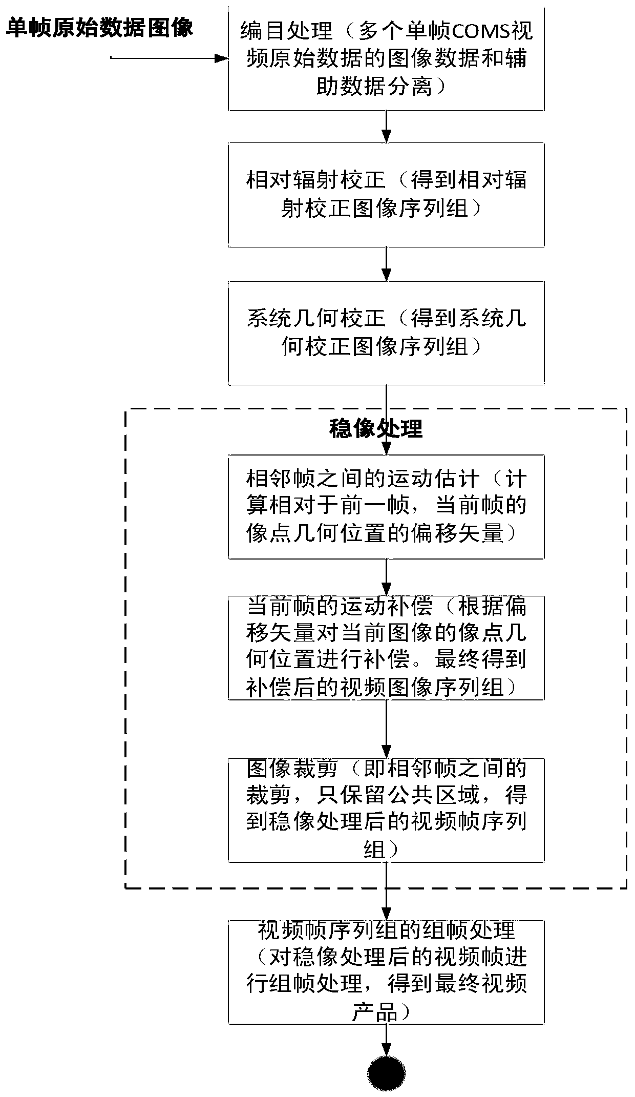
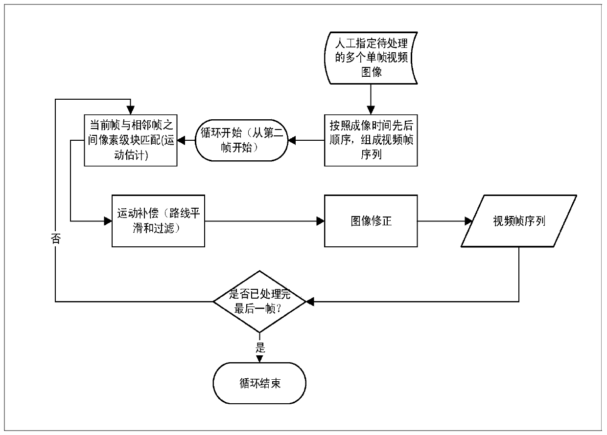
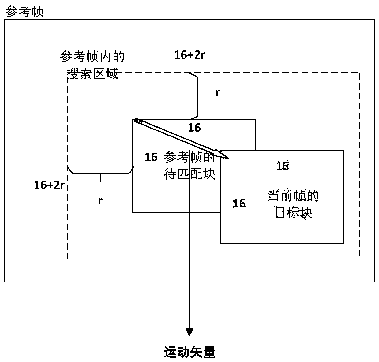
The invention discloses an image stabilization-based remote sensing video satellite image processing method and system, and the method comprises the steps: carrying out the cataloguing processing of each frame, extracting the imaging time of each frame, enabling the imaging time of each frame to serve as a part of an image name, and enabling a plurality of image frames to form an image frame sequence group according to the time sequence; performing relative radiation correction on each frame of the sequence group to eliminate atmospheric radiation; after radiation correction, performing systemgeometric correction on each frame of the sequence group to eliminate geometric distortion generated in the frame during imaging; Taking the previous frame as a reference frame, and carrying out image stabilization processing on each current frame except the first frame in the sequence group, including motion estimation, motion compensation and image correction; and combining the image frame sequences subjected to image stabilization processing to form a video. In the processing process of the remote sensing video satellite, the imaging characteristics of a general remote sensing satellite and a video satellite are considered, and the processing process obviously improves the quality of the remote sensing video.

Description

technical field [0001] The invention belongs to the technical field of satellite remote sensing and video applications, and in particular relates to a remote sensing video satellite image processing method and system based on image stabilization. Background technique [0002] With the rapid development and diversification of satellite application fields, the development of remote sensing video satellites is also increasing rapidly. Generally, remote sensing image errors mainly include the following aspects: system error, that is, the error of the sensor itself; the influence of atmospheric scattering; the influence of lighting conditions. [0003] Taking the remote sensing video satellite with CMOS camera as the research object, the remote sensing video processing method based on image stabilization is explained. For the area array "staring" video, the difference in the value of the outer orientation elements of each frame of the video is the main reason for the motion betw...

Claims


Application Information

Patent Timeline
IPC IPC(8): G06T5/00G06T7/207G06K9/00H04N5/232
Inventor 陈元伟侯叶叶张国梁李国全李龙飞
Owner SPACE STAR TECH CO LTD
Learn More