space-time continuous PM2.5 inversion method
An inversion, space-time technology, applied in the direction of instruments, electrical digital data processing, measuring devices, etc., can solve the problems of increasing the satellite AOD missing rate and low AOD inversion accuracy, so as to overcome the influence, improve the anti-noise ability and ensure stability sexual effect
- Summary
- Abstract
- Description
- Claims
- Application Information
AI Technical Summary
Problems solved by technology
Method used
Image
Examples
Embodiment 1
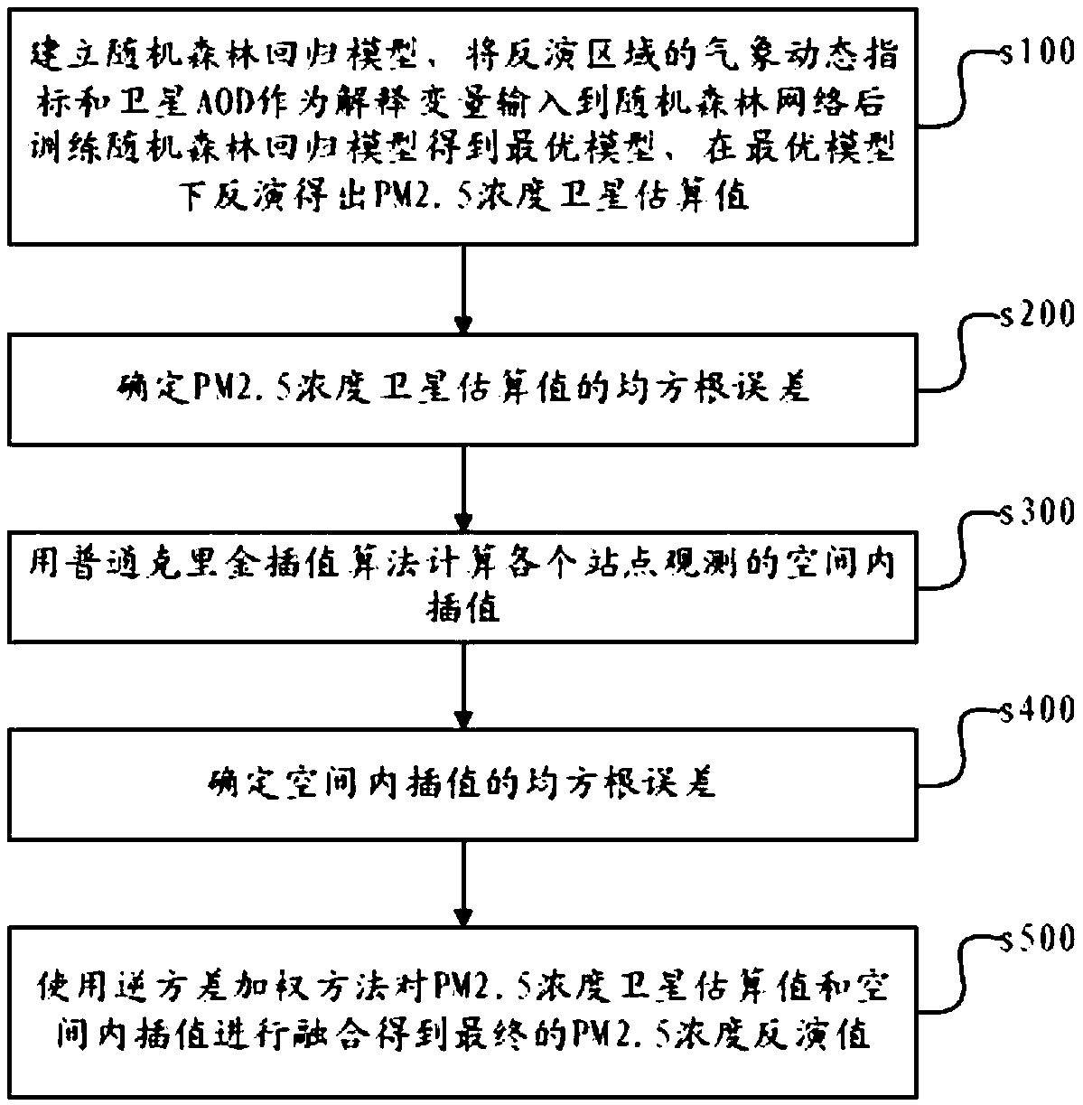
[0030] Embodiment one: if figure 1 As shown, a kind of space-time continuous PM2.5 inversion method that the application provides comprises the following steps:
[0031] s100. Establish a random forest regression model, input the meteorological dynamic indicators and satellite AOD in the inversion area as explanatory variables into the random forest network, then train the random forest regression model to obtain the optimal model, and invert the PM2.5 under the optimal model Concentration Satellite Estimates The dynamic indicators include the surface temperature, surface pressure, wind speed, relative humidity and boundary layer height of the monitoring area; AOD is the aerosol optical thickness, which is the integral of the aerosol extinction coefficient in the vertical direction, and quantitatively describes the reduction of the aerosol to light. The physical quantity of action can be used to characterize the degree of turbidity of the atmosphere.
[0032] The random fores...
Embodiment 2
[0042] Embodiment two, on the basis of the above-mentioned embodiment one, also includes the following steps before step s500:
[0043] s600. Create satellite estimates of PM2.5 concentration and spatial interpolation The fitting function of , which compensates for missing data from satellite observations.
[0044] Satellite observations have missing data, while spatial interpolation Due to the sparse and uneven distribution of stations, the interpolation accuracy also varies in space. Combining the results of the two can not only reduce the error to a certain extent, but also increase the spatial coverage of the inversion results. The specific execution process is divided into two steps. Firstly, the fitting function between the two is established, and there is a spatial interpolation function for no satellite observation. pixels to reconstruct the satellite retrieval results and fill in the missing data.
Embodiment 3
[0046] On the basis of the first embodiment, the monitoring area is divided into several sub-areas, and then PM2.5 inversion is performed on each sub-area using the method described in the first embodiment.
[0047] The specific segmentation method includes the following steps:
[0048] s710. Take the geographical static index and the measured concentration of PM2.5 as samples, and calculate the correlation coefficient between each static index and the measured concentration of PM2.5;
[0049] The static index refers to a parameter that is related to the PM2.5 concentration and does not change in a short period of time. In this embodiment, the static index is adopted as the artificial emission density of particulate matter AE, population density Pop and elevation DEM; for example, with the same At the time point, the measured concentration of PM2.5 at the monitoring station and the average emission density AE, population density Pop, and elevation DEM near the station are used...
PUM
 Abstract
Description
Claims
Application Information
 - R&D
- Intellectual Property
- Life Sciences
- Materials
- Tech Scout
- Unparalleled Data Quality
- Higher Quality Content
- 60% Fewer Hallucinations
Browse by: Latest US Patents, China's latest patents, Technical Efficacy Thesaurus, Application Domain, Technology Topic, Popular Technical Reports.
© 2025 PatSnap. All rights reserved.Legal|Privacy policy|Modern Slavery Act Transparency Statement|Sitemap|About US| Contact US: help@patsnap.com


