
Method for monitoring atmospheric environment of unmanned aerial vehicle area

A technology of environmental monitoring and unmanned aerial vehicles, applied in the direction of measuring devices, instruments, scientific instruments, etc., can solve the problem of single monitoring equipment

Inactive Publication Date: 2018-11-27
河南天腾航空科技有限公司
View PDF4 Cites 1 Cited by
  • Summary
  • Abstract
  • Description
  • Claims
  • Application Information

AI Technical Summary

Problems solved by technology

[0004] The purpose of the present invention is to provide a regional atmospheric environment monitoring method for unmanned aerial vehicles, so as to solve the problem in the above-mentioned background technology that there are very few people who use unmanned aerial vehicles to monitor the air quality at present. When the computer monitors the atmosphere, the monitoring equipment is too simple

Method used


Image

  • Method for monitoring atmospheric environment of unmanned aerial vehicle area
  • Method for monitoring atmospheric environment of unmanned aerial vehicle area

Examples


Embodiment

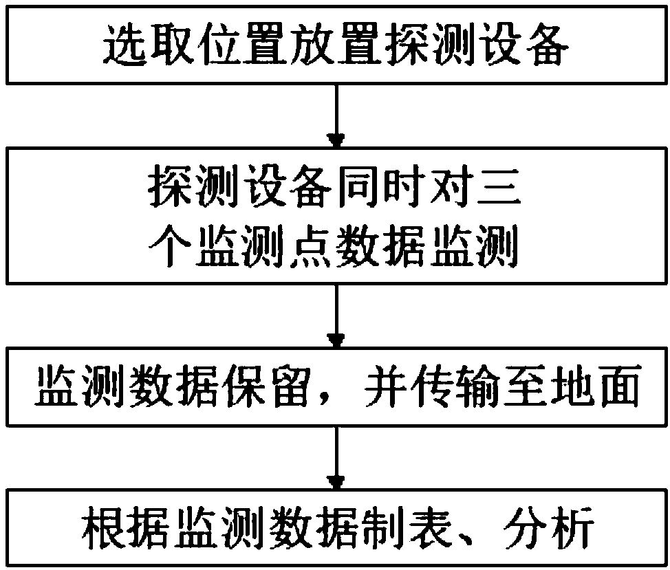
[0025] The specific monitoring method of the regional atmospheric environment monitoring method for the unmanned aerial vehicle is as follows:

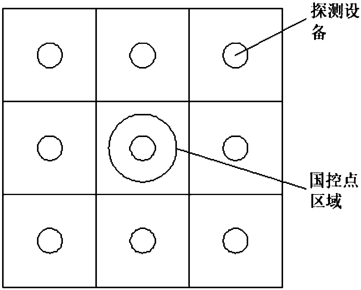
[0026] S1: Select a location to place the detection equipment: place the UAV detection equipment in a matrix around the national control point (such as figure 2 As shown), with the national control point as the center, the surrounding areas are divided in the form of a nine-square grid, and the national control point is located in the center of the nine-square grid, and nine sets of drone detection equipment are placed in the center of the nine-square grid;

[0027] Infrared distance sensor, ZigBee wireless transmission module, positioning module and air measurement sensor group are integrated on the UAV detection equipment. The air measurement sensor group includes atmospheric environment measurement sensors such as formaldehyde concentration sensor, PM2.5 concentration sensor, TVOC sensor and temperature and humidity sensor ;

[0...


PUM


Abstract

The invention discloses a method for monitoring an atmospheric environment of an unmanned aerial vehicle area and belongs to the technical field of atmospheric environmental monitoring. The method formonitoring the atmospheric environment of the unmanned aerial vehicle area comprises the following steps: S1) selecting a position and placing detecting device: placing unmanned aerial vehicle monitoring devices surrounding a to-be-monitored area in a matrix form according to a to-be-monitored position; S2) simultaneously monitoring data of three monitoring points by the detecting devices: simultaneously lifting the unmanned aerial vehicle monitoring devices in each area and monitoring the atmospheric environment of three altitude area monitoring sites in space according to the placing areasof the unmanned aerial vehicle monitoring devices in step S1); S3) reserving the monitoring data and transmitting to the ground; S4) making a table and analyzing according to the monitoring data. Thescheme is capable of specifically judging in the manner of collecting information of atmosphere in different altitude areas and is capable of more directly observing the relation between data and datain the manner of making the table.

Description

technical field [0001] The invention relates to the technical field of atmospheric environment monitoring, in particular to a regional atmospheric environment monitoring method for unmanned aerial vehicles. Background technique [0002] UAV is an unmanned aircraft operated by radio remote control equipment and self-contained program control device. According to the application field, UAV can be divided into military and civilian. In terms of military use, UAVs are divided into reconnaissance aircraft and target aircraft. In terms of civilian use, drones + industry applications are the real rigid needs of drones; currently, they are used in aerial photography, agriculture, plant protection, selfies, express delivery, disaster rescue, wildlife observation, infectious disease monitoring, surveying and mapping, news reports, and power inspections. Applications in fields such as disaster relief, film and television shooting, and romance manufacturing have greatly expanded the u...

Claims


Application Information

Patent Timeline
IPC IPC(8): G01N33/00
CPCG01N33/0031G01N33/0075
Inventor 韩恒刚杜从华谷常飞
Owner 河南天腾航空科技有限公司
Learn More