Method, vehicle and computing device for operating a navigation system including a vehicle and a computing device external to the vehicle

A technology for computing devices and vehicles, applied in the field of navigation systems, can solve the problem of not having the required map data storage capacity for this purpose, and achieve the effect of saving data

Active Publication Date: 2022-05-03
AUDI AG
View PDF8 Cites 0 Cited by
  • Summary
  • Abstract
  • Description
  • Claims
  • Application Information

AI Technical Summary

Problems solved by technology

For example, navigation to a specific fueling column or even a specific fueling gun inside a gas station cannot be realized by conventional navigation devices, because the vehicle usually does not have such a high-resolution topographical feature required for this purpose. Storage capacity of map data

Method used


Image

  • Method, vehicle and computing device for operating a navigation system including a vehicle and a computing device external to the vehicle
  • Method, vehicle and computing device for operating a navigation system including a vehicle and a computing device external to the vehicle

Examples


Embodiment Construction

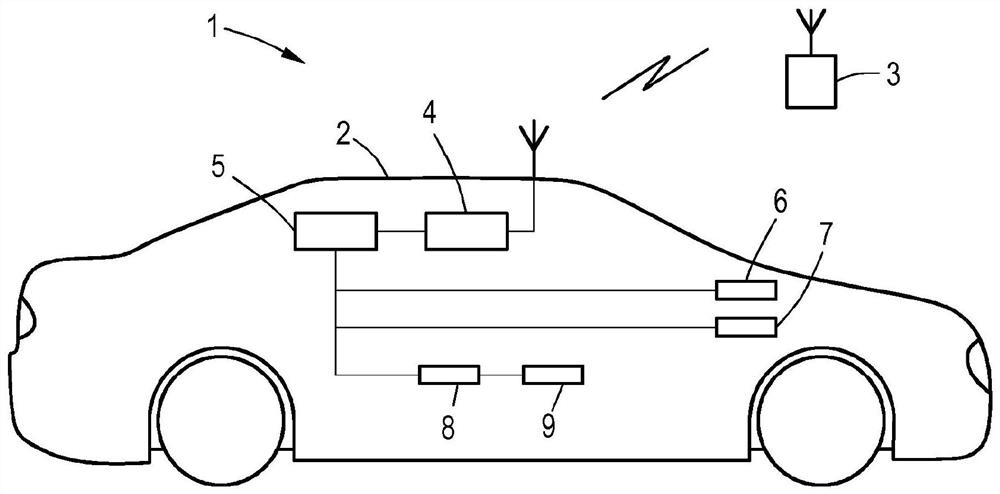
[0028] figure 1 A schematic diagram of an embodiment of a navigation system 1 comprising a vehicle 2 and a computing device 3 is shown.

[0029] The vehicle 2 is designed here as an autonomous motor vehicle, wherein in further exemplary embodiments the vehicle 2 is designed for semi-autonomous or only assisted or driverless transport systems or aircraft. Vehicle 2 has a communication device 4 for wireless data communication with computing device 3 and also has a navigation device 5 connected to communication device 4 . A visual and acoustic output device 6 and an input unit 7 for receiving manual and / or voice-activated inputs from the vehicle occupant are connected to the navigation system. A trajectory planning device 8 and a downstream lane tracking control device 9 are also provided, which use the navigation route data of the navigation device 5 to automatically control the vehicle 2 laterally or longitudinally. Trajectory planning device 8 is dispensed with in vehicles 2...


PUM


Abstract

The invention relates to a method for operating a navigation system (1) comprising a vehicle (2) and a computing device (3) external to the vehicle, wherein the navigation device (5) on the vehicle side receives information transmitted from the computing device (3) Determining, in the road network data describing the road sections (24-32) of the road network, including at least one road section (24-32), the required road area from the starting position (33) to the target position (34) segment sequence, whereby the navigation device (5) checks the availability of the road segment sequence for the vehicle (2), taking into account the road segment information transmitted by the computing device (3) at the request of the navigation device (5). passability and determine navigation routes derived from road segments judged to be passable.

Description

technical field [0001] The invention relates to a method for operating a navigation system comprising a vehicle / vehicle and a computing device external to the vehicle. Background technique [0002] Navigation devices for vehicles have been known for a long time. Navigation devices generally include digitally stored topographic maps and position detection devices, so that navigation in public road networks is possible. Topographical maps typically contain coordinates of so-called Points of Interest, which may describe car wash facilities, factory floors, gas stations, restaurants, or the like. Although it is thus easy to calculate a navigation route to such a noteworthy point, the vehicle usually therefore only reaches the immediate vicinity of the respective point, for example to an entrance. For example, navigation to a specific fueling column or even a specific fueling gun inside a gas station cannot be realized by conventional navigation devices, because the vehicle usu...

Claims


Application Information

Patent Timeline
Patent Type & Authority Patents(China)
IPC IPC(8): G01C21/34G05D1/02
CPCG01C21/34G05D2201/0213G05D1/0212G01C21/3461G01C21/3484G08G1/096822
Inventor E·罗斯D·伦茨P·米尼拉普陈超
Owner AUDI AG
Why Eureka
Try Eureka