
Satellite Calibration Method Based on Laser Detector Array Super-resolution

A laser detector and super-resolution technology, applied in satellite radio beacon positioning systems, instruments, measuring devices, etc., can solve the problem of low calibration accuracy and achieve the effect of overcoming low accuracy

Active Publication Date: 2021-06-25
XIDIAN UNIV
View PDF7 Cites 0 Cited by
  • Summary
  • Abstract
  • Description
  • Claims
  • Application Information

AI Technical Summary

Problems solved by technology

[0003] The purpose of the present invention is to overcome the deficiencies in the above-mentioned prior art, and provide a satellite calibration method based on laser detector array super-resolution, which is used to solve the technical problem of low calibration accuracy existing in the existing satellite calibration method

Method used


Image

  • Satellite Calibration Method Based on Laser Detector Array Super-resolution
  • Satellite Calibration Method Based on Laser Detector Array Super-resolution
  • Satellite Calibration Method Based on Laser Detector Array Super-resolution

Examples


Embodiment Construction

[0023] The present invention will be further described in detail below in conjunction with the accompanying drawings and specific embodiments.

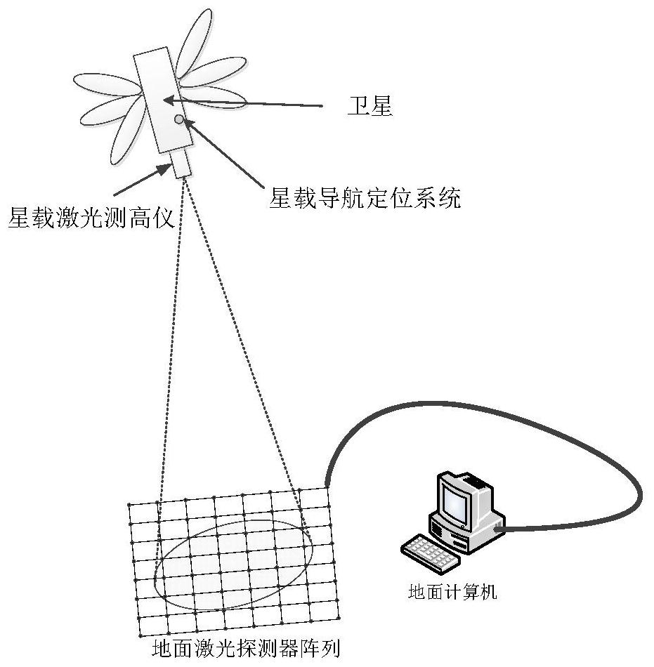
[0024] refer to figure 1 , a satellite calibration system based on laser detector array super-resolution, including a spaceborne laser altimeter, a spaceborne navigation and positioning system, a ground laser detector array and a ground computer. The role of the spaceborne laser altimeter is to emit laser Gaussian signals for the ground laser detectors to receive. The function of the spaceborne navigation and positioning system is to obtain the relative position of the satellite and the ground laser detector array and transmit the satellite positioning coordinate information to the ground computer. The function of the ground laser detector array is to obtain the energy information of the laser and quantify the energy level and transmit it to the ground computer. The ground computer obtains the super-resolution image through the ener...


PUM


Abstract

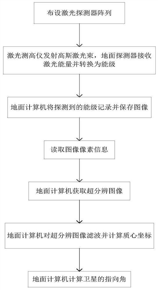
The invention proposes a satellite calibration method based on laser detector array super-resolution, which is used to solve the technical problem of low calibration accuracy existing in the existing satellite calibration method. The implementation steps are as follows: lay out the ground laser detector array; the spaceborne laser altimeter emits Gaussian pulsed laser to the ground laser detector array, each laser detector obtains the energy level value of the Gaussian pulsed laser, the ground computer obtains the energy level distribution map, and the ground The computer obtains the super-resolution image, the ground computer filters the super-resolution image, and calculates the centroid coordinates of the filtered image, and the ground computer obtains the pointing angle of the satellite. It is used in the field of on-orbit calibration of the space-borne laser altimeter altimeter system.

Description

technical field [0001] The invention belongs to the technical field of on-orbit calibration of space-borne laser altimeters, and designs a satellite calibration method, in particular to an on-orbit satellite calibration method of space-borne laser altimeters based on ground field super-resolution, which is used for space-borne The field of on-orbit calibration of laser altimeter altimetry system. Background technique [0002] When surveying and mapping satellites acquire satellite images, in order to generate high-resolution digital elevation models, accurate satellite calibration parameters must be provided. Satellite calibration is the pointing angle parameter between the satellite and the ground calculated from the data related to the satellite calibration system obtained by various sensors. Currently available calibration methods include calibration of mid-infrared sensors, cross-calibration of image and radiation transmission, single calibration of the relative deviati...

Claims


Application Information

Patent Timeline
Patent Type & Authority Patents(China)
IPC IPC(8): G01S19/40G01C25/00
CPCG01C25/00G01S19/40
Inventor 张静江从辉李云松孔孟行赵亮亮
Owner XIDIAN UNIV
Learn More