
Distributed unmanned aerial vehicle real-time mapping system based on cloud computing

A UAV, distributed technology, applied in radio transmission systems, transmission systems, surveying and navigation, etc., can solve the problems of limiting the efficiency of UAV surveying and mapping, the inability to complete real-time reconstruction, and the complexity of 3D reconstruction algorithms, etc., to achieve Improve the real-time performance of surveying and mapping, increase the speed of surveying and mapping, and save time

Inactive Publication Date: 2018-08-03
苏州光之翼智能科技有限公司
View PDF5 Cites 19 Cited by
  • Summary
  • Abstract
  • Description
  • Claims
  • Application Information

AI Technical Summary

Problems solved by technology

The ability to shoot and the computing power of a single ground station will also limit the efficiency of UAV mapping
[0007] Part of the mode is processed by multiple ground stations. Due to the limitation of the transmission distance and the complexity of the 3D reconstruction algorithm, real-time reconstruction cannot be completed.

Method used


Image

  • Distributed unmanned aerial vehicle real-time mapping system based on cloud computing
  • Distributed unmanned aerial vehicle real-time mapping system based on cloud computing
  • Distributed unmanned aerial vehicle real-time mapping system based on cloud computing

Examples


Embodiment Construction

[0060] The present invention will be described in detail below with reference to the accompanying drawings and in combination with embodiments.

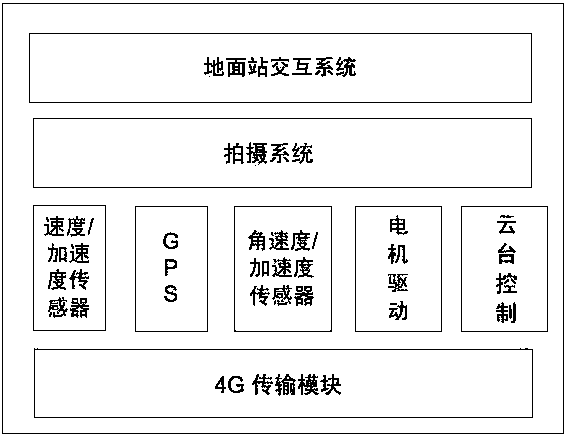
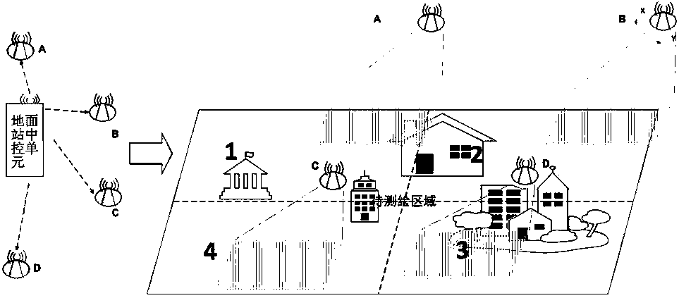
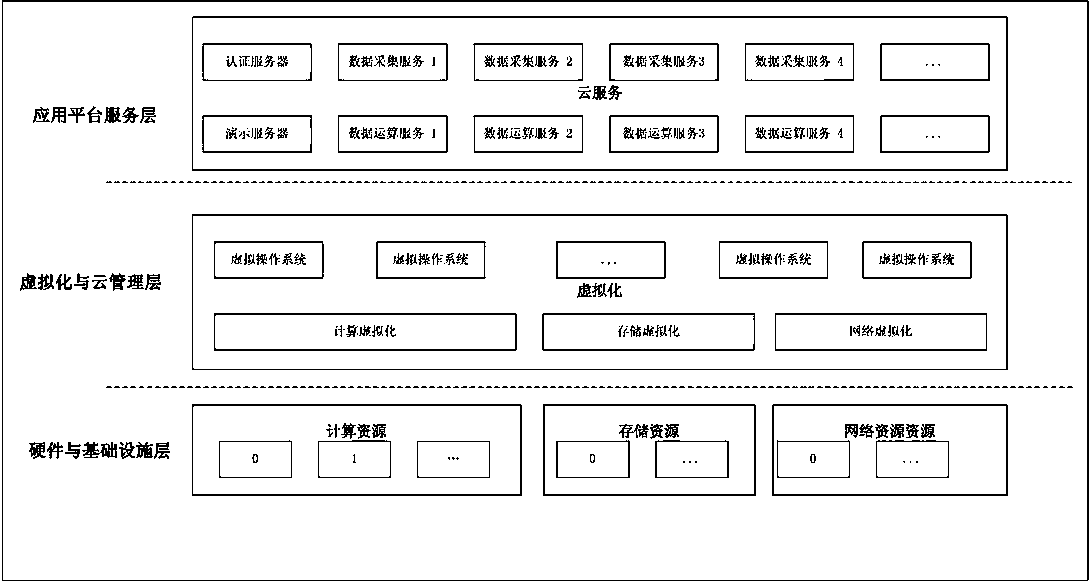
[0061] A real-time surveying and mapping system for distributed unmanned aerial vehicles based on cloud computing, including a ground station central control unit, a cloud service platform and an unmanned aerial vehicle. The unmanned aerial vehicle is equipped with a shooting system and a network transmission module. The unmanned aerial vehicle passes The network transmission module builds a network connection channel with the central control unit of the ground station and the cloud service platform, receives the control instruction data from the central control unit of the ground station, and transmits the picture data captured at fixed points during the flight by the shooting system to the cloud service platform. The cloud service platform is allocated image data acquisition storage resources and computing resources, and the image d...


PUM


Abstract

The invention relates to a distributed unmanned aerial vehicle real-time mapping system based on cloud computing. The system comprises a ground station central control unit, a cloud service platform and an unmanned aerial vehicle, a shooting system and a network transmission module are arranged on the unmanned aerial vehicle, the unmanned aerial vehicle constructs a network connection channel of the ground station central control unit and the cloud service platform through the network transmission module, receives control instruction data of the ground station central control unit, and transmits picture data shot by the shooting system in a flight process at a fixed point to the cloud service platform, the cloud service platform performs storage and three-dimensional reconstruction on thepicture data transmitted by the unmanned aerial vehicle, and the ground station central control unit plans the boundary of an area to be mapped, and configures and plans the mapping subarea accordingto the number of unmanned aerial vehicle clusters, and configures the corresponding unmanned aerial vehicle to fly to the mapping subarea to conform a subarea mapping node. The distributed unmanned aerial vehicle real-time mapping system can carry out large-scale mapping, can greatly improve the speed of mapping, save time, and can perform three-dimensional map reconstruction in real time, therebygreatly improving the real-time nature of mapping.

Description

technical field [0001] The invention relates to the technical field of multi-axis aircraft application, in particular to a cloud computing-based distributed unmanned aerial vehicle real-time surveying and mapping system. Background technique [0002] With the needs of digital city construction, security, and forest fire prevention, it is necessary to construct a three-dimensional geographic information map through aerial photography. Due to the advantages of lightness and flexibility, strong programming ability, and low environmental requirements, the application of UAVs in this area is gradually developing. [0003] With the help of the real-time image transmission system, the ground station system can receive images and location information in real time, and dynamically construct geographic information maps. [0004] The existing three-dimensional geographic information rendering requires professional personnel / aircraft with low-altitude flight qualifications to fly, and ...

Claims


Application Information

Patent Timeline
Patent Type & Authority Applications(China)
IPC IPC(8): H04L29/08H04N5/232G01C11/00H04B7/185H04L29/06
CPCH04B7/18517H04L63/08H04L67/06G01C11/00H04L67/51H04N23/60H04N23/80
Inventor 湛斌王猛丁军沈晶莹翟国华冯翼颜丙葵
Owner 苏州光之翼智能科技有限公司
Learn More