Conversion method for highway ten-meter stake marks and longitude and latitude degrees

A technology of expressway and conversion method, which is applied to instruments, computers, meter look-up devices, etc., can solve problems such as inability to meet precise positioning, and achieve the effect of convenient labeling and display, and rapid inter-turning.

Inactive Publication Date: 2018-07-13
NANJING WANDAO ELECTRONICS TECH CO LTD
View PDF5 Cites 6 Cited by
  • Summary
  • Abstract
  • Description
  • Claims
  • Application Information

AI Technical Summary

Problems solved by technology

[0002] Expressways are high-grade highways. Generally speaking, expressways can adapt to a speed of 120 km / h or higher. The road surface has a width of more than four lanes, and a divider is set in the middle. The asphalt concrete or cement concrete high-grade road surface is used. There are complete signs, markings, signals and lighting devices; pedestrians and non-motorized vehicles are prohibited from walking on the road, and other lines are passed through by three-dimensional intersections, pedestrian overpasses or tunnels; Road stakes will be set at intervals on the road to mark the mileage or distance of the route. With the development of electronic information, mobile phone map navigation has gradually become an essential tool for people to travel. The data of mobile map is usually the same as the highway The stake number is combined to locate the user's location. At present, the existing expressway stake number and latitude and longitude conversion method can only realize the conversion between the entire kilometer stake number and the longitude and latitude with a distance of one thousand meters, which cannot meet the requirements of accurate positioning needs

Method used


Image

  • Conversion method for highway ten-meter stake marks and longitude and latitude degrees
  • Conversion method for highway ten-meter stake marks and longitude and latitude degrees
  • Conversion method for highway ten-meter stake marks and longitude and latitude degrees

Examples


Embodiment 1

[0031] The present embodiment is the conversion method of expressway ten meter pile number and longitude and latitude, comprises the following steps:

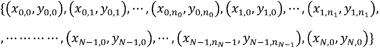
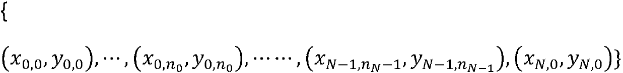
[0032] S1. Integrate the latitude and longitude data of the expressway road and the latitude and longitude data of the kilometer pile, and use the Isomap algorithm, that is, the equidistant feature mapping algorithm to sort the road points and the pile number points according to the direction of road travel, and perform road curves in two-dimensional space. Dimensionality reduction, forming a one-dimensional straight line, and sorting the road points in the latitude and longitude data of the highway road and the stake number points in the latitude and longitude data of the kilometer pile according to the road direction, forming a series of point collections along the same direction of the road:

[0033]

[0034] where (x i,k ,y i,k ) represents the latitude and longitude of the kth road point between the two kilometer piles...


PUM


Abstract

The invention provides a conversion method for highway ten-meter stake marks and longitude and latitude degrees, and aims to realize mutual conversion of stake marks and longitude and latitude degreesof highway ten-meter stakes accurately; a corresponding table of the ten-meter stake marks and the longitude and latitude degrees within the error range of 2 meters can be obtained, so that rapid mutual conversion of the ten-meter stake marks and the longitude and latitude degrees is realized; the stake marks are accurately converted into the longitude and latitude degrees with the precision of 10+ / -2 meters in common marking means of highway, and the stake marks are conveniently marked and displayed in a map.

Description

technical field [0001] The invention relates to a method for converting the ten-meter pile number and latitude and longitude of expressways, and belongs to the technical field of highway traffic management. Background technique [0002] Expressways are high-grade highways. Generally speaking, expressways can adapt to a speed of 120 km / h or higher. The road surface has a width of more than four lanes, and a divider is set in the middle. There are complete signs, markings, signals and lighting devices; pedestrians and non-motor vehicles are prohibited from walking on the road, and other lines are crossed by three-dimensional intersections, pedestrian overpasses or tunnels; Road stakes will be set at intervals on the road to mark the mileage or distance of the route. With the development of electronic information, mobile phone map navigation has gradually become an essential tool for people to travel. The data of mobile map is usually the same as that of highway The stake numb...

Claims


Application Information

Patent Timeline
IPC IPC(8): G06C3/00
CPCG06C3/00
Inventor 张磊袁舒流李越
Owner NANJING WANDAO ELECTRONICS TECH CO LTD
Why Eureka
Try Eureka