
A hydrological data acquisition method and a virtual hydrological station

A data acquisition and data technology, which is applied in water resources assessment, climate sustainability, instruments, etc., can solve the problems of inability to communicate hydrological information to the outside world, damage to the ground communication network, etc., and achieve the effect of improving hydrological monitoring capabilities.

Active Publication Date: 2019-07-02
李骚
View PDF5 Cites 0 Cited by
  • Summary
  • Abstract
  • Description
  • Claims
  • Application Information

AI Technical Summary

Problems solved by technology

Especially after the occurrence of various serious disasters, the ground communication network may be damaged, and the hydrological information cannot be notified to the outside world in time

Method used


Image

  • A hydrological data acquisition method and a virtual hydrological station
  • A hydrological data acquisition method and a virtual hydrological station
  • A hydrological data acquisition method and a virtual hydrological station

Examples


Embodiment Construction

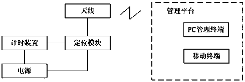
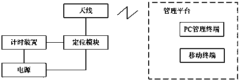
[0034] The present invention firstly provides a virtual hydrological station. The virtual hydrological station does not rely on the existing communication system that needs to lay base stations, and directly transmits information through satellites. It can be applied to areas with remote environments and no base station signal coverage. This virtual hydrographic station is realized by a floating ball floating in the river. The floating ball includes a spherical shell, and a processor is arranged inside the spherical shell, and a positioning module, a power supply module, a clock module, a storage module, and an antenna are connected to the processor, wherein the antenna is connected to the radio frequency signal end of the positioning module, and the positioning module passes The antenna transmits the three-dimensional positioning signal and time information to the management platform. The management platform can choose the server or mobile terminal of the hydrological monitor...


PUM


Abstract

The invention provides a hydrologic data acquisition method. The method comprises the steps that V pieces of GPS range data which needs to be sent and belongs to hydrologic data is acquired and storedin a storage module in a floating ball; the floating ball is put from an initial position to be measured to a river to be measured, and in the flowing process of the floating ball along the water flow, current GPS data is acquired through a communication circuit of a GPS positioning module in real time or at set time intervals; a processor compares the current GPS data with the GPS range data which is stored in the storage module, if the current GPS data falls into a certain piece of GPS range data, and three or more sets of hydrologic data measured by the current floating ball are sent to amanagement platform through the communication circuit of a Beidou positioning module at set sending time intervals in sequence, wherein the hydrologic data comprises three-dimensional positioning information and time information, acquired by the GPS positioning module, at the current position. According to the hydrologic data acquisition method, the hydrologic monitoring capacity is improved, therequirements of disaster prevention and reduction and water resource management can be met, and the scientific data support is provided for construction of a hydrologic information system.

Description

technical field [0001] The invention relates to the field of flow monitoring, in particular to a virtual hydrological station based on satellite three-dimensional positioning and a method for acquiring hydrological data using the virtual hydrological station. Background technique [0002] Due to the aging of some reservoirs and river lifting facilities in our country, the dam body seepage, and the dam body are weak, dam failures are prone to occur when heavy rainfall occurs, causing major mountain torrent disasters, damaging downstream farms, bridges, power and other facilities, It will even pose a great threat to the personal and property safety of local residents. Especially after various serious disasters occur, the ground communication network may be damaged, and the hydrological information cannot be notified to the outside world in time. Contents of the invention [0003] In order to solve the deficiencies in the prior art, the present invention provides a virtual h...

Claims


Application Information

Patent Timeline
Patent Type & Authority Patents(China)
IPC IPC(8): G01F1/66G01S19/14G01S19/33
CPCG01F1/66G01S19/14G01S19/33Y02A90/30
Inventor 李骚
Owner 李骚
Learn More