A Method of Detachable and Composite Mapping

A map and graphics technology, applied in the field of cartography, can solve the problems of lack of flexibility in the visual expression of complex features, difficult to solve personalized symbol expression, and dynamic changes of element mapping conflict attributes, etc., to achieve fast and flexible symbol configuration and convenient management Effect

Active Publication Date: 2021-08-17
CHINESE ACAD OF SURVEYING & MAPPING
View PDF8 Cites 0 Cited by
  • Summary
  • Abstract
  • Description
  • Claims
  • Application Information

AI Technical Summary

Problems solved by technology

This method has a simple structure and is easy to use. Usually, the cartographic expression of simple elements of general ground features can be completed with the help of the symbol library, but it cannot fully meet the requirements of cartographic specifications and graphical representation, and it lacks flexibility for the visual expression of complex ground features. , it is difficult to solve the symbolic expression of personalized symbolic expression, element mapping conflicts and dynamic changes of attributes

Method used


Image

  • A Method of Detachable and Composite Mapping
  • A Method of Detachable and Composite Mapping
  • A Method of Detachable and Composite Mapping

Examples


Embodiment Construction

[0019] The following will clearly and completely describe the technical solutions in the embodiments of the present invention with reference to the drawings in the embodiments of the present invention.

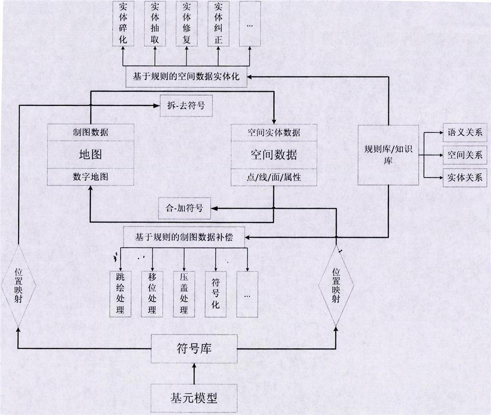
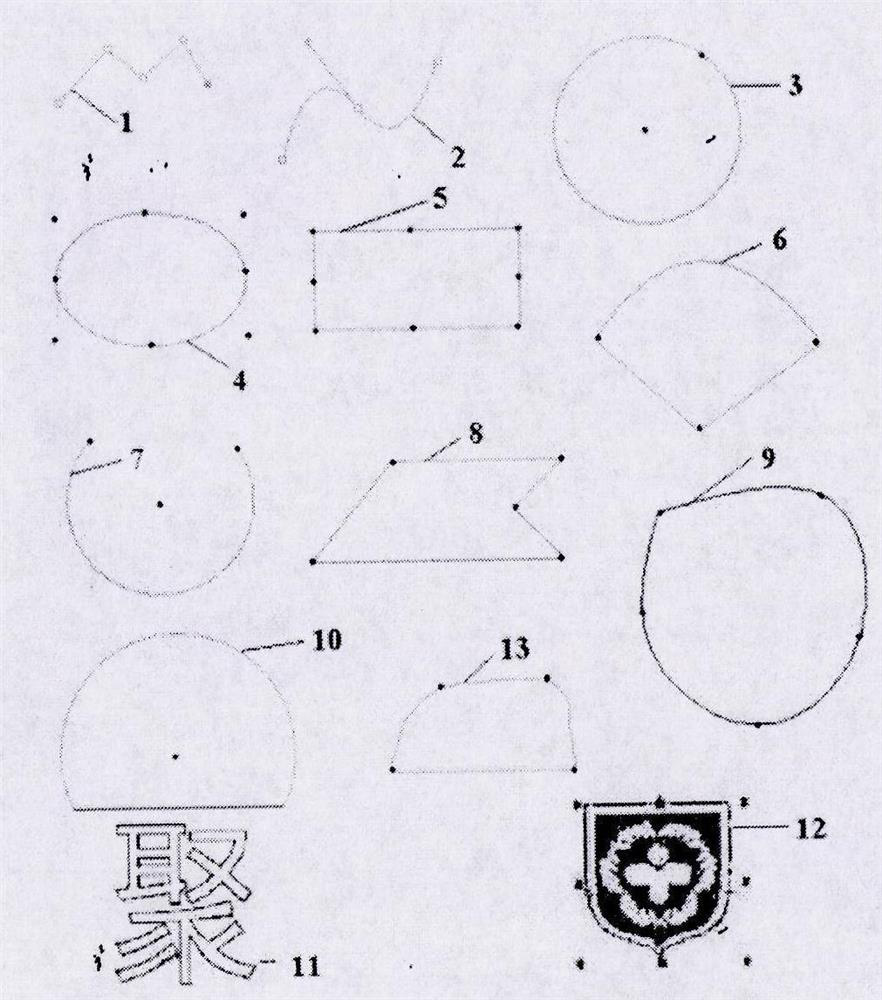
[0020] see Figure 1-7 , in an embodiment of the present invention, a method and system for detachable map drawing, including the following steps: A. Establishing a map primitive model, and making complex and diverse symbols through the primitive model to form a map symbol system; B. , Establish the spatial location mapping between map symbols and geographic objects, and realize the link between the two; C, separate processing of map numbers, focus on entity generation and topology processing of geographic data itself on the basis of discarding symbol data; D, integration of map numbers Processing, combining symbolic data with spatial entity data such as points, lines, and planes, and producing digital maps through map element conflict processing and map symbolization. The st...


PUM


Abstract

The invention discloses a map-number detachable mapping method and system, comprising the following steps: A. establishing a map primitive model, and making complex and diverse symbols through the primitive model to form a map symbol system; B. establishing a map Spatial location mapping between symbols and geographic objects, to realize the link between the two; C. Separate processing of graphs and numbers, on the basis of discarding symbolic data, focus on the entity generation and topology processing of geographic data itself; D. Integrated processing of graphs and numbers, the Symbolic data is combined with spatial entity data such as points, lines, and surfaces, and through map element conflict processing and map symbolization, digital maps are produced. The present invention realizes the logical division management of symbol system, map data and spatial data, and the three are related by the location coordinates of geographic space, so that the management of geographic elements can be conveniently managed, and the symbol of map data can be realized quickly and flexibly. configuration.

Description

technical field [0001] The invention relates to a drawing method, in particular to a drawing method with detachable figures. Background technique [0002] In the 21st century, information technology has brought unprecedented changes to cartography. Many cartographic work done by hand in the past has been replaced by digital cartography, which greatly improves the efficiency of map production. At present, graph databases use digital cartography model (DCM) to organize and manage map graphic symbol data; spatial databases use digital landscape model (DLM) to store and analyze spatial data. The two are distinct and interrelated. In GIS, spatial data refers to data that reflects the location, attributes, and topological relationships of spatial geographic entities. Spatial data abstracts spatial objects into three geometric types: point, line, and surface. The data has standard classification and coding, standard layering, Graphical elements are continuous and have complete at...

Claims


Application Information

Patent Timeline
Patent Type & Authority Patents(China)
IPC IPC(8): G06T11/20
CPCG06T11/20
Inventor 李成名殷勇刘晓丽印洁郭沛沛吴伟王伟尤西霞洪志远金志国
Owner CHINESE ACAD OF SURVEYING & MAPPING
Why Eureka
Try Eureka