Satellite/ inertial ultra-tight integration system and method based on Beidou/GPS dual-mode software receiver

A technology of software receiver and ultra-tight combination, applied in satellite radio beacon positioning system, radio wave measurement system, measuring device, etc., can solve the lack of super-tight combination research, no further use of navigation information, super-tight combination stay theory Issues such as demonstration and simulation at the method level, to achieve the effect of improving the geometric precision factor, improving the positioning accuracy and reliability, and improving the positioning accuracy

Active Publication Date: 2018-02-02
SOUTHEAST UNIV
View PDF5 Cites 14 Cited by
  • Summary
  • Abstract
  • Description
  • Claims
  • Application Information

AI Technical Summary

Problems solved by technology

[0007] 1. Research is often carried out on the basis of loose combination and tight combination, by increasing the feedback channel of inertial navigation results to satellite receivers, without further using more primitive navigation information
[0008] 2. Due to the relatively mature research on GPS at home and abroad, the research on ultra-tight combination is usually aimed at the ultra-tight combination of GPS satellite navigation system. For multi-mode receivers, especially the research on ultra-tight combination involving Beidou receivers relatively lacking
[0009] 3. The domestic research on ultra-tight combination often stays at the theoretical and methodological level of demonstration and simulation, lacking in the exploration of engineering realization

Method used


Image

  • Satellite/ inertial ultra-tight integration system and method based on Beidou/GPS dual-mode software receiver
  • Satellite/ inertial ultra-tight integration system and method based on Beidou/GPS dual-mode software receiver
  • Satellite/ inertial ultra-tight integration system and method based on Beidou/GPS dual-mode software receiver

Examples


Embodiment Construction

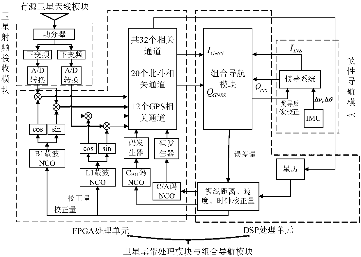
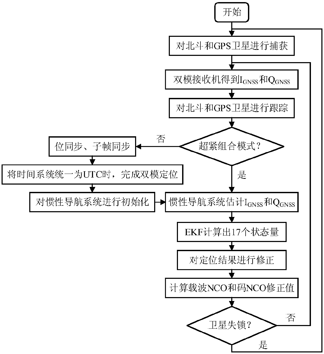
[0045] Such as figure 1 As shown, a satellite / inertial ultra-tight combination system based on Beidou / GPS dual-mode software receiver is based on FPGA+DSP architecture in hardware, including: active satellite antenna module, satellite radio frequency receiving module, satellite baseband processing module, Inertial navigation module and integrated navigation module.

[0046] The active satellite antenna module can simultaneously receive the signal of GPS L1 frequency point and Beidou B1 frequency point, divide the signal into two channels through the power divider, and connect to the two channels of the satellite RF receiving module for band-pass filtering and low-noise amplification . The GPS L1 channel and the Beidou B1 channel generate 1575MHz and 1561MHz local oscillator signals respectively, which are mixed with the input signal, so that the GPS L1 signal is down-converted to 0.42MHz I and Q baseband signals with approximately zero intermediate frequency, and the Beidou B...


PUM


Abstract

The invention discloses a satellite/ inertial ultra-tight integration system and method based on a Beidou/GPS dual-mode software receiver. The system comprises an active satellite antenna module, a satellite radio frequency receiving module, a satellite baseband processing module, an inertial navigation module and an integrated navigation module. The method comprises the following steps: after theBeidou/GPS dual-mode software receiver finishes first positioning, carrying out initialization on an inertial navigation system; entering an ultra-tight integration mode, and estimating I,Q information IINS and QINS; serving the difference value between I,Q information obtained by the Beidou/GPS dual-mode software receiver and the IINS and QINS as observed quantity of an EKF; carrying out correction on the inertial navigation system; and estimating carrier Doppler frequency and pseudo code phase of a satellite signal, and feeding the carrier Doppler frequency and the pseudo code phase back toa carrier NCO and a code NCO to form a closed loop. The system and method can improve positioning accuracy of the satellite/ inertial integrated navigation system, improve system robustness, and improve tracking performance of the satellite receiver under high-dynamic weak-signal and strong-interference conditions.

Description

technical field [0001] The invention relates to the field of Beidou technology application, multi-sensor data fusion and application, in particular to a satellite / inertial ultra-tight combination system and method based on Beidou / GPS dual-mode software receiver. Background technique [0002] Satellite navigation system and inertial navigation system have highly complementary characteristics, which have been widely used in satellite / inertial integrated navigation system. Traditional satellite / inertial integrated navigation systems usually adopt two information fusion methods: loose combination and tight combination. In the loosely combined working mode, the satellite navigation system and the inertial navigation system work independently, and output navigation information such as position, speed, attitude, etc., and then perform data fusion through the navigation filter. The tight combination uses more original navigation information, and takes the difference between the pse...

Claims


Application Information

Patent Timeline
Patent Type & Authority Applications(China)
IPC IPC(8): G01S19/47G01S19/33
CPCG01S19/33G01S19/47
Inventor 陈熙源闫晣汤新华张梦尧
Owner SOUTHEAST UNIV
Why Eureka
Try Eureka