
Pyramid Modeling System and Method of Irregular Triangular Network of Global Geographical Framework

An irregular and triangular network technology, which is applied in the field of the irregular triangular network pyramid modeling system of the global geographic framework, can solve the problems such as the inability to realize the pyramid layered block model of the irregular triangular network surface surface model, and the lack of substantial application. , to achieve the effect of reducing the amount of data

Active Publication Date: 2020-09-15
陈树铭
View PDF2 Cites 0 Cited by
  • Summary
  • Abstract
  • Description
  • Claims
  • Application Information

AI Technical Summary

Problems solved by technology

[0003] At present, the mainstream 3D digital earth platform (including but not limited to Google Earth, Skyline, Arc Globe, etc.), has applied the basic technical principles of pyramid layered and block modeling (tile pyramid model modeling), and has realized the earth under the global geographic framework. The three-dimensional browsing and visual expression of surface models have been widely used in three-dimensional navigation, positioning, browsing, query and other application levels; but in the analysis and application of engineering construction survey, design, construction, operation, geological disaster Specialized analysis and application, meteorological professional analysis and application, marine professional analysis and application, environmental professional analysis and application, military professional analysis and application and other fields have not achieved substantive application and progress; the main reason is that The surface digital elevation model (DEM) used in the mainstream 3D digital earth platform is a rasterized surface model realized by referring to the layered and block modeling principle of the picture pyramid, and it is an incomplete raster model in mathematics (that is, Integer geographic model), while the model required in the professional field must be a complete three-dimensional irregular triangulation surface model (that is, a real geographic model)
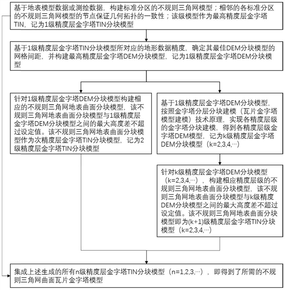
[0004] The existing mainstream 3D digital earth platform can only construct a pyramid layered block model for the incomplete grid surface model (DEM), but cannot realize the irregular triangular network surface model. Defects of the pyramid layered block model

Method used


Image

  • Pyramid Modeling System and Method of Irregular Triangular Network of Global Geographical Framework
  • Pyramid Modeling System and Method of Irregular Triangular Network of Global Geographical Framework
  • Pyramid Modeling System and Method of Irregular Triangular Network of Global Geographical Framework

Examples


Embodiment Construction

[0062] Embodiments of the present invention are described in detail below, and examples of the embodiments are shown in the drawings, wherein the same or similar reference numerals denote the same or similar elements or elements having the same or similar functions throughout. The embodiments described below by referring to the figures are exemplary and are intended to explain the present invention and should not be construed as limiting the present invention.

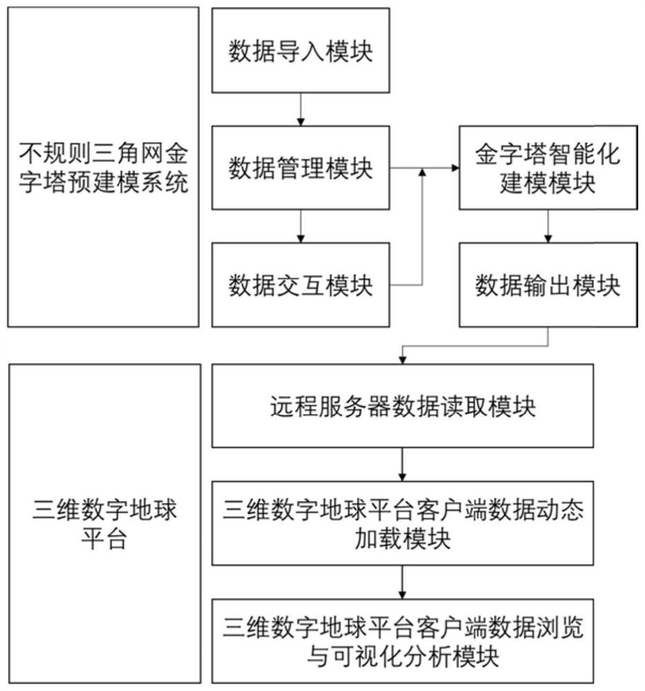
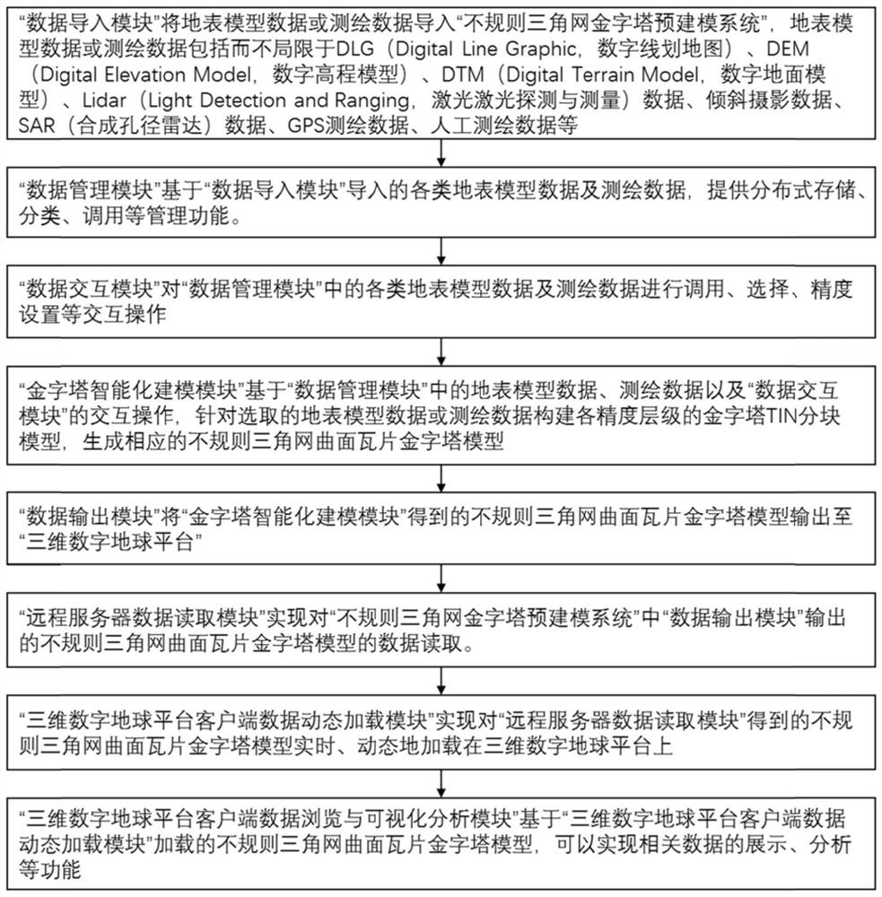
[0063] The global geographic frame irregular triangular network pyramid modeling system and method of the embodiment of the present invention are aimed at various surface model data (including but not limited to DLG, DEM, DTM, Lidar data, oblique photography data, SAR data) under the global geographic frame , GPS surveying and mapping data, manual surveying and mapping data, etc.), based on the adaptive principle of three-dimensional irregular surface features, the technical method, system and application of three-dimen...


PUM


Abstract

The invention provides a modeling system and method for a triangular irregular network pyramid of a global geographic framework. The modeling system for the triangular irregular network pyramid of the global geographic framework further comprises a data importing module, a data management module, a data interaction module, an intelligent pyramid modeling module and a data output module; a three-dimensional digital earth platform further comprises a remote server data reading module, a three-dimensional digital earth platform client data dynamic loading module, and a three-dimensional digital earth platform client data browsing and visual analysis module. Compared with a pyramid DEM block model with a corresponding precision level, a pyramid TIN (Triangular Irregular Network) block model having the corresponding precision level and built based on an adaptive principle of three-dimensional irregular curved surface features has the advantages that geometric shape feature information of the pyramid TIN block model is basically kept constant but the data amount is greatly reduced.

Description

technical field [0001] The invention relates to the technical field of three-dimensional digital modeling, in particular to a system and method for modeling a global geographic frame irregular triangular network pyramid. Background technique [0002] The basic principle of pyramid layered block modeling (tile pyramid model modeling) technology is: ①The maximum number of continuous resolution picture frames per second of human vision does not exceed a maximum value; The number of resolution pixels does not exceed a maximum value; ③The range size of the picture seen by human vision at different distances is positively correlated with the minimum resolution size, and the larger the range, the greater the minimum resolution size; ④The geographic information model under the global geographic framework , according to the height of the camera from the earth's surface, the pyramid level and blocks are pre-constructed. The farther the camera is from the earth, the larger the range of...

Claims


Application Information

Patent Timeline
Patent Type & Authority Patents(China)
IPC IPC(8): G06T17/20
CPCG06T17/20
Inventor 陈树铭陈超东叶望张乐杨宇文
Owner 陈树铭
Learn More