Calculation method of land cover sample size considering spatial composition and configuration

A technology of land cover and calculation method, which is applied in the field of spatial analysis and can solve problems such as the inability to fully reflect the spatial heterogeneity of land cover and the imperfect calculation results.

Active Publication Date: 2019-08-06
NAT GEOMATICS CENT OF CHINA
View PDF4 Cites 0 Cited by
  • Summary
  • Abstract
  • Description
  • Claims
  • Application Information

AI Technical Summary

Problems solved by technology

However, the spatial heterogeneity of land cover is composed of spatial composition and spatial configuration. The SW index only measures the spatial composition, and the LSI index only measures the spatial configuration. Neither of these two indices can fully reflect the spatial heterogeneity of land cover. Therefore, the calculation results based on SW index and LSI index are still incomplete

Method used


Image

  • Calculation method of land cover sample size considering spatial composition and configuration
  • Calculation method of land cover sample size considering spatial composition and configuration
  • Calculation method of land cover sample size considering spatial composition and configuration

Examples


example 1

[0049] Calculate the sample sizes of desert rivers, forest-grass transition zones, and vegetation-mixed zones.

[0050] Among them, desert rivers have simple spatial composition, simple spatial configuration, and the weakest spatial heterogeneity; forest-grass transition zone has simple spatial composition, complex spatial configuration, and intermediate spatial heterogeneity; The structure is complex and the spatial heterogeneity is the strongest.

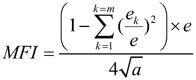
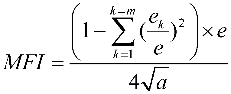
[0051] A. Calculate the comprehensive index MFI of desert rivers, forest-grass transition areas, and vegetation mixed areas, respectively, to describe the spatial heterogeneity of the grid.

[0052] The spatial heterogeneity of land cover can be divided into spatial composition and spatial configuration. Spatial composition refers to the characteristics such as the type, quantity, and area ratio of land cover types, and spatial configuration refers to the characteristics such as the size, shape, number, and density of land cover ...

example 2

[0091] Example 2: Calculate the sample sizes of Libya, Somalia, and Zimbabwe. Among them, Libya has simple spatial composition, simple spatial configuration, and the weakest spatial heterogeneity; Somalia has simple spatial composition, complex spatial configuration, and middle spatial heterogeneity; Zimbabwe has complex spatial composition, complex spatial configuration, and the weakest spatial heterogeneity. powerful.

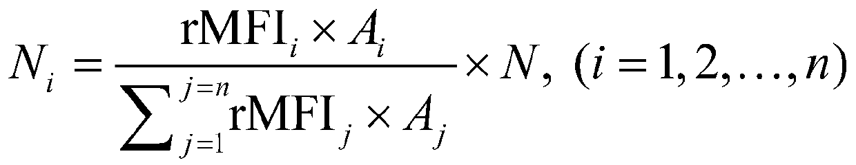
[0092] A. Because the regional areas of Libya, Somalia, and Zimbabwe are quite different (Libya has an area of ​​1.76 million square kilometers, Somalia has an area of ​​640,000 square kilometers, and Zimbabwe has an area of ​​390,000 square kilometers), the regional MFIs of Libya, Somalia, and Zimbabwe should be calculated. Divide Libya, Somalia, and Zimbabwe into regular grids of 1×1 km, calculate the comprehensive index MFI of land cover in each grid, and use the average of all grid MFIs as the regional MFI index.

[0093] The MFI index is affected by the...


PUM


Abstract

The invention relates to a space construction and configuration-considered land cover sample capacity calculation method. The method comprises the following steps of: 1) dividing to-be-verified areas into a plurality of equal-area rectangular regular grids; 2) calculating a comprehensive index MFI of space construction and configuration of each rectangular regular grid; 3) calculating total space construction and configuration rMFI of the to-be-verified areas according to the comprehensive index MFI of space construction and configuration of each rectangular regular grid; 4) obtaining a sample total capacity N of all the to-be-verified area; and 5) distributing the sample total capacity N, of all the to-be-verified areas, obtained in the step 4) according to the total space construction and configuration rMFI calculated in the step 3). According to the space construction and configuration-considered land cover sample capacity calculation method, the land cover space construction and configuration of verified areas are measured, the spatial heterogeneities of the verified areas are described, and data support is provided for calculating the sample capacity of the verified areas.

Description

technical field [0001] The invention belongs to the technical field of spatial analysis, and relates to a method for calculating the sample size of land cover, in particular to a land cover that can calculate the sample size of a test sample by comparing the spatial heterogeneity of the land cover in different regions, taking into account the spatial composition and configuration of the land surface Overrides the sample size calculation method. Background technique [0002] The production of land cover data is to use the rich spectrum, texture features and space-time relationship contained in aerospace and aerial remote sensing images, combine various reference materials and related knowledge, and use methods such as mathematical statistics and interactive interpretation to extract its types of attribute information and Spatial distribution (see Chen Jun, Chen Jin, Liao Anping, et al. 2016 Remote Sensing Mapping of Global Land Cover. Science Press). In data production, the ...

Claims


Application Information

Patent Timeline
Patent Type & Authority Patents(China)
IPC IPC(8): G06F17/50G06F17/18
CPCG16Z99/00
Inventor 陈军陈斐武昊
Owner NAT GEOMATICS CENT OF CHINA
Why Eureka
Try Eureka