Mars final approaching section autonomous navigation method based on relative measurement information

An autonomous navigation and relative measurement technology, applied in the field of deep space exploration, can solve problems such as planetary ephemeris errors and influence of navigation results, and achieve the effects of reducing state divergence, reducing adverse effects, and improving navigation performance

Active Publication Date: 2017-05-17
BEIJING INSTITUTE OF TECHNOLOGYGY
View PDF3 Cites 18 Cited by
  • Summary
  • Abstract
  • Description
  • Claims
  • Application Information

AI Technical Summary

Problems solved by technology

However, in the process of using the absolute measurement information of pulsars for navigation, planetary ephemeris errors will inevitably be introduced during state transitions
At the same time, the inherent parameters of X-ray pulsars (distance, azimuth, etc.) will also affect the navigation results

Method used


Image

  • Mars final approaching section autonomous navigation method based on relative measurement information
  • Mars final approaching section autonomous navigation method based on relative measurement information
  • Mars final approaching section autonomous navigation method based on relative measurement information

Examples


Embodiment 1

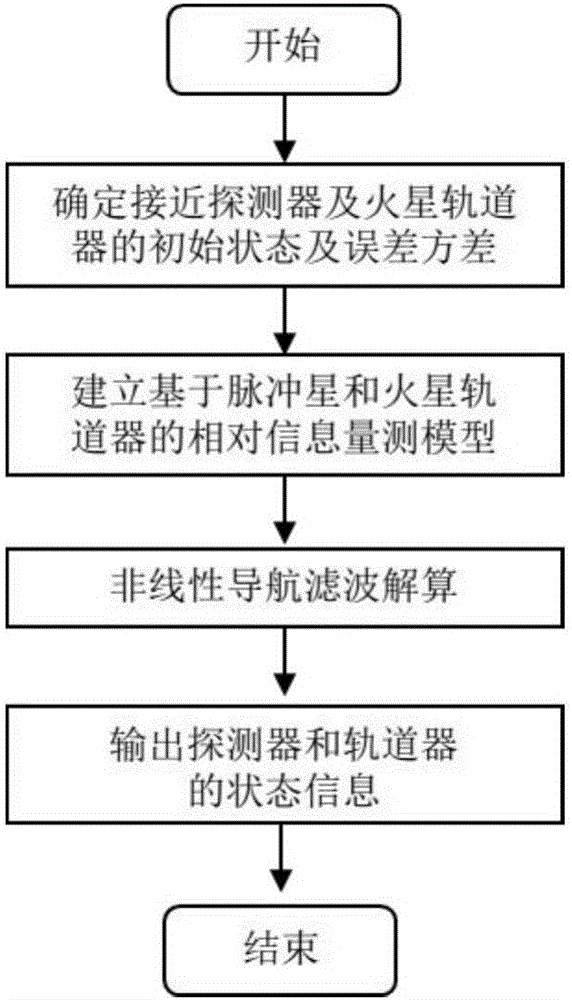
[0057] A method for autonomous navigation of the Mars final approach segment based on relative measurement information disclosed in this example includes the following steps:

[0058] Step 1: Establish a dynamic model of Mars' final approach and orbit.

[0059] The dynamic model of the navigation system for the final Mars approach segment and orbit segment is established in the J2000 Mars center inertial coordinate system. The twelve-dimensional state vector includes the position and velocity vector of the Mars approaching probe represented by the subscript s and the position and velocity vector of the Mars orbiter represented by the subscript o, denoted as

[0060]

[0061] where r s =[r x,s r y,s r z,s ] T ,v s =[v x,s v y,s v z,s ] T ;

[0062] where r o =[r x,o r y,o r z,o ] T ,v o =[v x,o v y,o v z,o ] T .

[0063] Using J 2 The two-body dynamics equation under the disturbance is used as the system dynamics model for state recursion, ...


PUM


Abstract

The invention discloses a Mars final approaching section autonomous navigation method based on relative measurement information, and belongs to the technical field of deep space exploration. For achieving Mars final approaching section autonomous navigation, a final approaching and surrounding dynamic model is established. According to differential information of X-ray pulsar arrival time and Doppler velocity measurement information of a Mars orbiter, based on nonlinear filtering algorithm, the states of an approaching detector and the Mars orbiter undergo joint estimation, absolute navigation is achieved through utilization of two kinds of relative measurement information including the differential information of X-ray pulsar arrival time and the Doppler velocity measurement information of the Mars orbiter, and the accuracy of Mars final approaching section autonomous navigation and the accuracy of entry point state estimation are improved. The method has the following advantages: introduction of a planet ephemeris error is avoided, the adverse effect on navigation performance due to nondeterminacy of pulsar parameters is limited, the problem of state divergence resulting from long observation time of pulsars is overcome, the navigation performance of two detectors is improved at the same time, and the navigation filter accuracy and the convergence speed are increased.

Description

technical field [0001] The invention relates to an autonomous navigation method for the final approaching stage of Mars, belonging to the technical field of deep space exploration. Background technique [0002] Fixed-point landing technology (landing accuracy within 100m) can meet the mission requirements of the probe landing on a preset location with scientific research value on the surface of Mars or safely landing in complex terrain areas, and has received extensive attention in recent years. The landing accuracy of the entry-descent landing (EDL) system is affected by four main factors, including: the delivery error of the entry interface, the cognitive uncertainty of the entry interface, the environmental uncertainty, and the performance of the detector itself (transfer capability, etc.). The application of new technologies such as atmospheric entry guidance can eliminate the adverse effects caused by the delivery error of the entry point and the environmental uncertain...

Claims


Application Information

Patent Timeline
IPC IPC(8): G01C21/24
CPCG01C21/24
Inventor 崔平远王硕高艾朱圣英于正湜徐瑞
Owner BEIJING INSTITUTE OF TECHNOLOGYGY
Why Eureka
Try Eureka