Geostationary Satellite Imaging Navigation and Registration Star North-South Parameter Extraction Method and System

A technology for geostationary satellites and parameter extraction, which is applied in navigation, astronomical navigation, surveying and navigation, etc., can solve the problem of not merging multiple detectors, and achieve the effect of improving recognition accuracy

Active Publication Date: 2019-06-21
SHANGHAI SATELLITE ENG INST
View PDF7 Cites 0 Cited by
  • Summary
  • Abstract
  • Description
  • Claims
  • Application Information

AI Technical Summary

Problems solved by technology

[0008] Li Xiaokun, Wang Ganquan, and Chen Guilin introduced the Fengyun-4 satellite scanning in the article "FY-4 Meteorological Satellite Scanning Imager - Visible Light Channel Stellar Sensitivity" in Science Technology and Engineering Volume 7, Issue 6 (March 2007). The imager uses the star-sensitive method to solve the internal deformation of the instrument, and proposes to obtain the position of the star passing through the detector through weighted analysis, but it does not fuse the data of multiple detectors

Method used


Image

  • Geostationary Satellite Imaging Navigation and Registration Star North-South Parameter Extraction Method and System
  • Geostationary Satellite Imaging Navigation and Registration Star North-South Parameter Extraction Method and System
  • Geostationary Satellite Imaging Navigation and Registration Star North-South Parameter Extraction Method and System

Examples


Embodiment Construction

[0051] The present invention will be described in detail below in conjunction with specific embodiments. The following examples will help those skilled in the art to further understand the present invention, but do not limit the present invention in any form. It should be noted that those skilled in the art can make several changes and improvements without departing from the concept of the present invention. These all belong to the protection scope of the present invention.

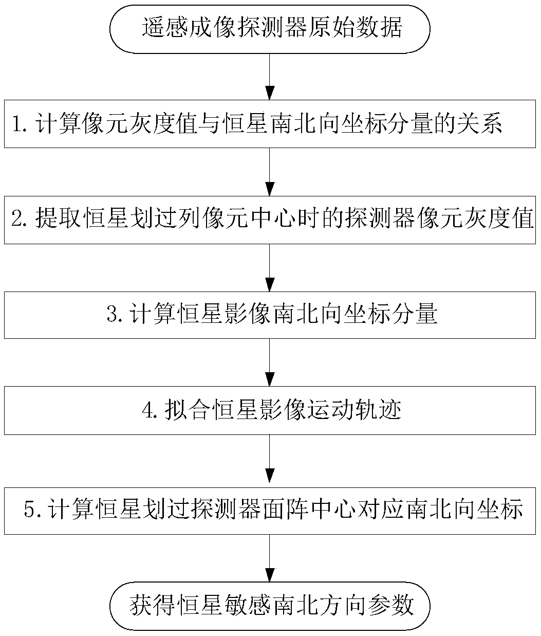
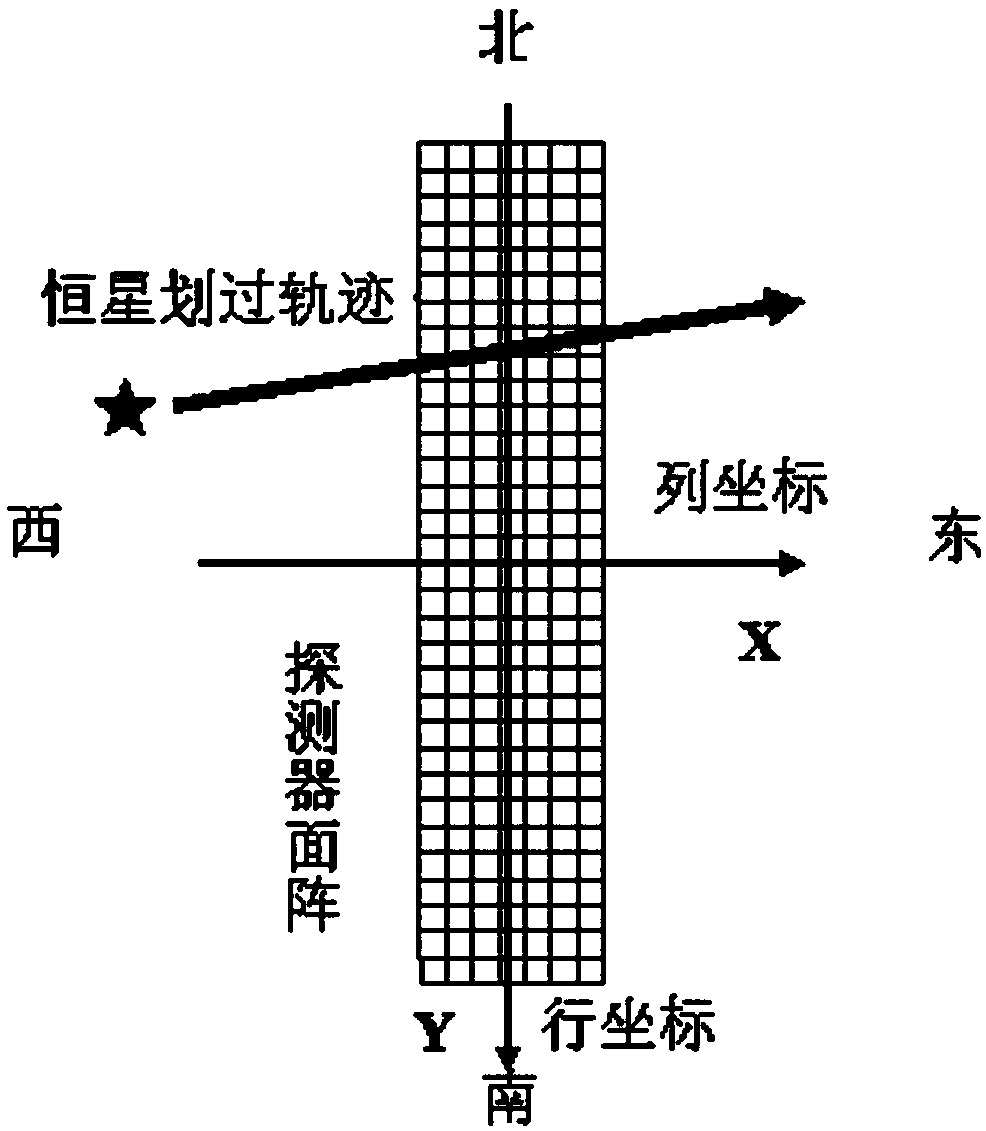
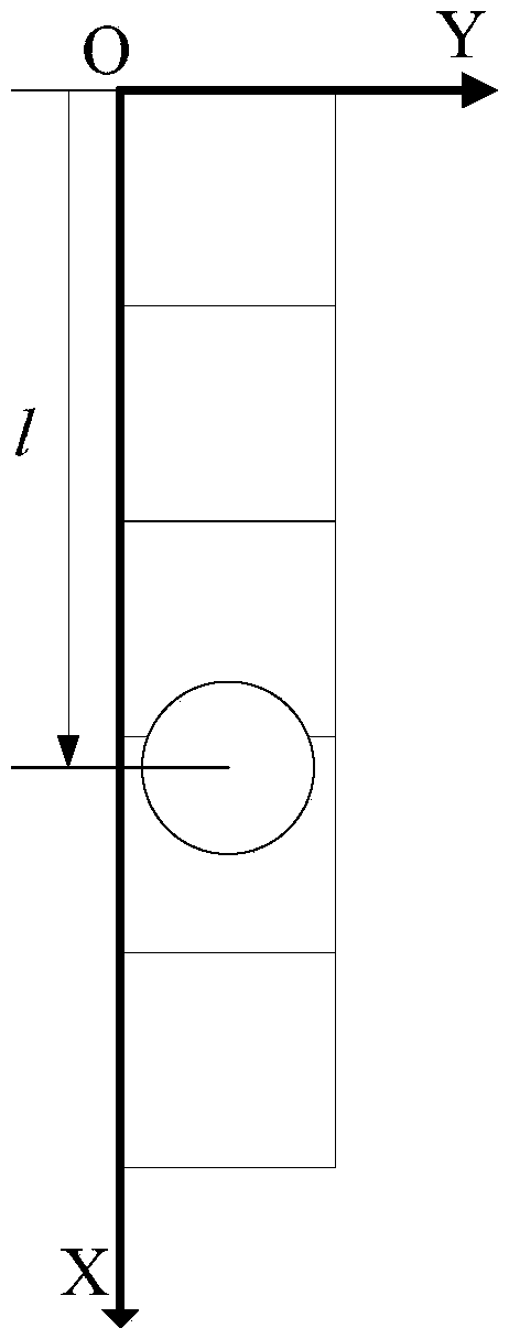
[0052] The present invention calculates the north-south coordinate component of the star image in a single column of pixels according to the point spread function of the star image; uses the calculation results of the north-south coordinate components of multiple columns of pixels to fit the north-south movement track of the star image, and extracts the star sensitive north-south parameter. According to the point spread function, the overlapping area of ​​the star image and the column pixel is integrated...


PUM


Abstract

The invention provides a geostationary satellite imaging navigation and registration fixed star north and south parameter extraction method, and a system. The geostationary satellite imaging navigation and registration fixed star north and south parameter extraction method comprises following steps: 1, the relationship of the grey level of column image elements with fixed star image north and south direction coordinate components is established; 2, detector image element grey level when a fixed star passes through the column image element center is extracted; 3, the fixed star north and south direction coordinate components are calculated; 4, the north and south direction coordinate components when the center of a fixed star image passes through the center line of the east and west direction of the detector are calculated. According to the geostationary satellite imaging navigation and registration fixed star north and south parameter extraction method, in calculating of fixed star image coordinates, fixed star image shape and brightness distribution characters are taken into consideration fully, identification precision is increased greatly; and multiple column image elements calculation results are subjected to least square fit so as to reduce star position high-frequency error caused by factors such as detector optical imaging, circuit noise, and satellite high frequency jitter.

Description

technical field [0001] The invention relates to digital signal and image processing technology, in particular to a method and system for extracting north-south parameters of stationary satellite imaging navigation and registration stars. Background technique [0002] With the improvement of the application technology of remote sensing satellites, it is usually required that the images of the ground imaged by high-precision geostationary satellites be precisely positioned and registered to the nominal grid of the earth. However, satellite platforms and remote sensing instruments are affected by factors such as space mechanical environment and thermal environment changes. Satellites will have orbital drift and attitude pointing deviations, and instruments will produce geometric deformation, which will affect the positioning and registration accuracy of remote sensing images. Satellite imaging navigation and registration technology can solve such problems: the satellite perform...

Claims


Application Information

Patent Timeline
Patent Type & Authority Patents(China)
IPC IPC(8): G01C21/02
CPCG01C21/025
Inventor 吕旺王田野董瑶海王皓沈毅力
Owner SHANGHAI SATELLITE ENG INST
Why Eureka
Try Eureka