


Quick Research
Generate reliable direction feasibility study reports for your R&D in just a few steps.

Technical Q&A
Discover and master advanced knowledge NOW. Basics, ideas, possibilities, all at once.

Find Solutions
As an expert in R&D theories, this can generate solutions to your technical problems instantly.

Evaluate Feasibility
Analyze your overall solution with one click, know your potential R&D risks in advance.

Monitor Landscape
Get weekly tech updates, stay abreast of the latest tech innovations and key insights.
Three-dimensional laser scanning-based land expropriation and housing removal physical goods investigation method and investigation system thereof
A three-dimensional laser and survey system technology, applied in the direction of optical devices, image data processing, measuring devices, etc., can solve the problems of inability to make detailed statistics and query of topography, inconvenient adjustment and modification, high probability of error, etc., to meet the requirements of ease of use and Convenience, easy adjustment and modification, and strong applicability
- Summary
- Abstract
- Description
- Claims
- Application Information
AI Technical Summary
Problems solved by technology
Method used
Image

Examples
specific Embodiment 1
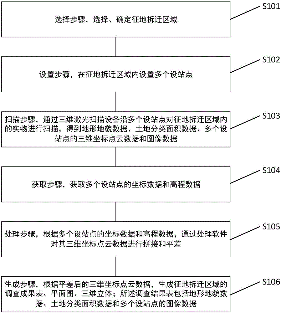
[0042] Such as figure 1 As shown, the embodiment of the present invention provides a method for physical investigation of land acquisition and demolition based on three-dimensional laser scanning, including selection steps, setting steps, scanning steps, acquisition steps, processing steps, and generation steps, wherein:
[0043] The selection step is to select and determine the land acquisition and demolition area;
[0044] The setting step is to set up multiple design sites in the land acquisition and demolition area;
[0045] In the scanning step, the physical objects in the land acquisition and demolition area are scanned by a 3D laser scanning device along multiple sites to obtain topography data, land classification area data, 3D coordinate point cloud data and image data of multiple site sites;
[0046] The acquisition step is to acquire the coordinate data and elevation data of multiple set points;
[0047] The processing step is to stitch and adjust the three-dimensio...
specific Embodiment 2
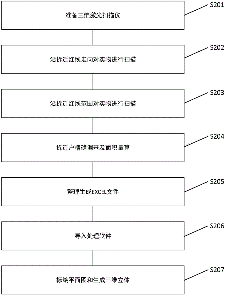
[0055] Such as figure 2 As shown, the embodiment of the present invention provides a specific embodiment, and describes in detail the physical investigation method for land expropriation and resettlement based on three-dimensional laser scanning proposed in the above embodiment.
[0056] In a specific embodiment of the present invention, refer to figure 2 shown, including the following steps:
[0057] S201, preparing a three-dimensional laser scanner;
[0058] The technical requirements of the 3D laser scanner: it has a camera function and has a GPS module;
[0059] The physical survey record method based on 3D laser scanning can be:
[0060] Investigators set up 3D laser scanning equipment to scan the physical object along the predetermined site. The main content of the scan includes the following four aspects:
[0061] 1) Point information, record the three-dimensional coordinates of the current point through laser scanning at the predetermined site, and the feature el...
specific Embodiment 3
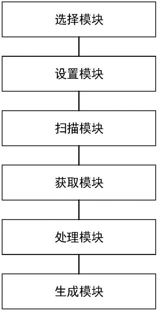
[0111] Such as image 3 As shown, the embodiment of the present invention provides a land expropriation and demolition object investigation system based on three-dimensional laser scanning, including a selection module, a setting module, a scanning module, an acquisition module, an adjustment module, and a generation module, wherein:
[0112] The selection module is used to select and determine the land acquisition and demolition area;
[0113] The setting module is used to set multiple setting points in the land acquisition and demolition area;
[0114] The scanning module is used to scan the physical objects in the land expropriation and demolition area along multiple sites with a 3D laser scanning device to obtain topographical data, land classification area data, 3D coordinate point cloud data and image data of multiple site sites;
[0115] The acquisition module is used to acquire coordinate data and elevation data of a plurality of setting points;
[0116] The adjustme...
PUM
 Abstract
Description
Claims
Application Information
 - R&D Engineer
- R&D Manager
- IP Professional
- Industry Leading Data Capabilities
- Powerful AI technology
- Patent DNA Extraction
Browse by: Latest US Patents, China's latest patents, Technical Efficacy Thesaurus, Application Domain, Technology Topic, Popular Technical Reports.
© 2024 PatSnap. All rights reserved.Legal|Privacy policy|Modern Slavery Act Transparency Statement|Sitemap|About US| Contact US: help@patsnap.com