Agricultural information service method and device
A technology of information service and agriculture, applied in the field of information processing
- Summary
- Abstract
- Description
- Claims
- Application Information
AI Technical Summary
Problems solved by technology
Method used
Image


Examples
Embodiment 1
[0097] refer to figure 1 , which shows a flow chart of the steps of Embodiment 1 of an agricultural information service method of the present invention, which may specifically include:
[0098] Step 101, determining the geographical information and environmental information of the user's plot;
[0099] Specifically, in this step, the server side, such as the agricultural information service platform, determines the geographic information and environmental information of the user's plot.
[0100] The "land block" mentioned here is determined by remote sensing technology and surveying and mapping technology, and is the smallest division unit of land; the shape of the land block can be regular or irregular, and its specific shape depends on the actual land division. The landform and natural landform are jointly formed; correspondingly, the area of the plots may be the same or different. Usually, for onshore land, the common plot unit is "mu" as the area division unit, that is,...
Embodiment 2
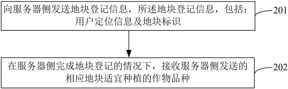
[0164] refer to figure 2 , which shows a flow chart of the steps of an embodiment of an agricultural information service method of the present invention, which may specifically include:
[0165] Step 201, sending the land parcel registration information bit information and the land parcel identification to the server side;
[0166] Specifically, in this step, the server side may refer to an agricultural information service platform or other equipment capable of information processing.
[0167] The "land block" mentioned here is determined by remote sensing technology and surveying and mapping technology, and is the smallest division unit of land; the shape of the land block can be regular or irregular, and its specific shape depends on the actual land division. The landform and natural landform are jointly formed; correspondingly, the area of the plots may be the same or different. Usually, for onshore land, the common plot unit is "mu" as the area division unit, that is, ...
PUM
 Abstract
Description
Claims
Application Information
 - R&D
- Intellectual Property
- Life Sciences
- Materials
- Tech Scout
- Unparalleled Data Quality
- Higher Quality Content
- 60% Fewer Hallucinations
Browse by: Latest US Patents, China's latest patents, Technical Efficacy Thesaurus, Application Domain, Technology Topic, Popular Technical Reports.
© 2025 PatSnap. All rights reserved.Legal|Privacy policy|Modern Slavery Act Transparency Statement|Sitemap|About US| Contact US: help@patsnap.com