
Traffic accident scene investigation system based on unmanned aerial vehicle and WIFI (wireless fidelity)

A technology of unmanned aerial vehicles and traffic accidents, which is applied in the field of traffic accident site investigation system based on unmanned aerial vehicles and WIFI, can solve the problems of complex receiver structure and high price, and achieve the goals of improving efficiency, accurate positioning, and reducing personnel consumption Effect

Inactive Publication Date: 2016-10-26
杨超坤
View PDF3 Cites 0 Cited by
  • Summary
  • Abstract
  • Description
  • Claims
  • Application Information

AI Technical Summary

Problems solved by technology

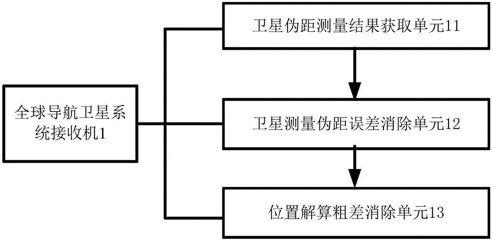
However, GNSS receivers with satellite positioning enhancements generally have complex structures and high prices

Method used


Image

  • Traffic accident scene investigation system based on unmanned aerial vehicle and WIFI (wireless fidelity)
  • Traffic accident scene investigation system based on unmanned aerial vehicle and WIFI (wireless fidelity)
  • Traffic accident scene investigation system based on unmanned aerial vehicle and WIFI (wireless fidelity)

Examples


Embodiment Construction

[0012] The present invention is further described in conjunction with the following examples.

[0013] Application Scenario 1

[0014] see figure 1 , figure 2 , a traffic accident site investigation system based on unmanned aerial vehicles and WIFI in one embodiment of this application scenario, comprising a traffic accident site investigation system and a global navigation satellite system receiver connected to the traffic accident site investigation system, characterized in that, The traffic accident on-site investigation system includes an on-site calibration subsystem, an on-site image acquisition subsystem, a data processing subsystem, a real-time communication subsystem and a drawing subsystem.

[0015] Preferably, the calibration subsystem includes a set of 4 calibration objects, and each calibration object has a WIFI positioning module and a self-position WIFI sending module.

[0016] The above embodiment of the present invention has accurate positioning, greatly i...


PUM


Abstract

The invention provides a traffic accident scene investigation system based on an unmanned aerial vehicle and WIFI (wireless fidelity). The traffic accident scene investigation system comprises a traffic accident scene investigation system and a global navigation satellite system receiving machine connected with the traffic accident scene investigation system. The traffic accident scene investigation system is characterized in that the traffic accident scene investigation system comprises a scene calibration sub system, a scene image obtaining sub system, a data processing sub system, a real-time communication sub system and a drawing sub system. The traffic accident scene investigation system has the advantages that the positioning is accurate; the accident scene investigation efficiency and accuracy are greatly improved; the personnel consumption and the indirect loss caused by accidents are reduced; the occurrence of secondary traffic accidents is effectively avoided.

Description

technical field [0001] The invention relates to the field of traffic accident site survey, in particular to a traffic accident site survey system based on an unmanned aerial vehicle and WIFI. Background technique [0002] With the increase of the number of traffic accidents and the strengthening of people's legal awareness, higher requirements are put forward for the accurate determination of the responsibility for road traffic accidents. The traditional traffic accident scene survey method uses a tape measure to measure the distance, and then manually draws the traffic accident scene sketch and scene scale map, which wastes a lot of time and is likely to cause secondary accidents. On the other hand, people hope that the traffic accident scene survey system can Provide precise positioning function. [0003] In order to improve the accuracy of satellite positioning as much as possible, a variety of satellite positioning enhancement technologies have been developed, such as l...

Claims


Application Information

Patent Timeline
Patent Type & Authority Applications(China)
IPC IPC(8): G01C11/00G01S19/42
CPCG01C11/00G01S19/42
Inventor 不公告发明人
Owner 杨超坤
Learn More