Unmanned aerial vehicle for surveying and mapping

A technology of unmanned aerial vehicles and airframes, which is applied in the field of unmanned aerial vehicle surveying and mapping, can solve the problems of limited use and single function, and achieve the effect of easy portability, complete functions, and simple maintenance and use

Inactive Publication Date: 2016-10-26
河南华泰规划勘测设计咨询有限公司
View PDF7 Cites 2 Cited by
  • Summary
  • Abstract
  • Description
  • Claims
  • Application Information

AI Technical Summary

Problems solved by technology

[0006] Aiming at the problems existing in the above technologies, the present invention provides a surveying and mapping unmanned aerial vehicle, which solves the problems of limited use and single function in the prior art

Method used


Image

  • Unmanned aerial vehicle for surveying and mapping

Examples


Embodiment Construction

[0019] The object of the present invention is to provide a surveying and mapping UAV, which solves the problems of limited use and single function in the prior art.

[0020] In order to achieve the above object, the technical scheme of the present invention is as follows:

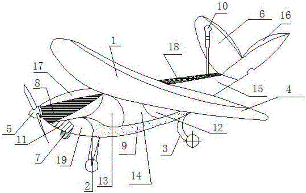
[0021] figure 1 As shown in , a surveying and mapping unmanned aerial vehicle, which includes: body 1, front landing gear 2, rear landing gear 3, wing 4, propeller 5, tail fin 6, infrared distance measuring device 7, motor 8, battery 9, radio Transmitting and receiving device 10 , night vision device 11 , autopilot 12 , surveying and mapping tool cabin 13 , GPS positioning device 14 , storage device 15 , rudder 16 , umbrella cabin 17 , and solar panel 18 .

[0022] The front end of the lower part of the body 1 is provided with a landing gear 2 and the rear part is provided with a rear landing gear 3, the body is connected to the wing 4, the empennage 6 is installed at the tail of the body 1, and the motor ...


PUM


Abstract

The invention relates to the field of unmanned aerial vehicle surveying and mapping, in particular to an unmanned aerial vehicle for surveying and mapping. The problems of using limitation, function simplicity and the like in the prior art are solved. The unmanned aerial vehicle for surveying and mapping is invented for meeting the requirements for disaster evaluation, emergency monitoring, geographical mapping, environmental evaluation and the like. The unmanned aerial vehicle for surveying and mapping has the multiple functions of surveying, mapping, communication, rescuing, data forwarding, power generating and the like, and the functions are complete; measurement of multiple data can be achieved at the same time; a solar power generating device is arranged, the overall working time of the unmanned aerial vehicle is prolonged, and the energy-saving environment-friendly effect is achieved. The unmanned aerial vehicle has the characteristics of being portable, easy to maintain and use, low in cost, reusable and the like, has wide market demand and is easy to apply and popularize.

Description

technical field [0001] The invention relates to the field of unmanned aerial vehicle surveying and mapping, in particular to a surveying and mapping unmanned aerial vehicle. Background technique [0002] Surveying and mapping is widely used in economic construction and national defense construction. In urban and rural construction planning, land resource utilization, environmental protection, etc., it is necessary to carry out land surveying and surveying and mapping of various maps for planning and management purposes. [0003] According to the application field, UAV can be divided into military and civilian. In terms of military use, UAVs are divided into reconnaissance aircraft and target aircraft. In terms of civilian use, drones + industry applications are the real rigid needs of drones; currently, they are used in aerial photography, agriculture, plant protection, selfies, express delivery, disaster rescue, wildlife observation, infectious disease monitoring, surveyi...

Claims


Application Information

Patent Timeline
Patent Type & Authority Applications(China)
IPC IPC(8): B64C39/00B64D47/00
CPCB64C39/00B64D47/00B64U10/25B64U2101/30B64U2201/10
Inventor 王超王东风
Owner 河南华泰规划勘测设计咨询有限公司
Why Eureka
Try Eureka