A Method of Building Damage Detection in Aerial Imagery Based on Shadow and Texture Features

An aerial image and texture feature technology, applied in image analysis, image enhancement, image data processing, etc., can solve problems such as complex, difficult to have multi-temporal LIDAR data, and small size of stereo image pairs

Active Publication Date: 2018-03-13
WUHAN UNIV
View PDF3 Cites 0 Cited by
  • Summary
  • Abstract
  • Description
  • Claims
  • Application Information

AI Technical Summary

Problems solved by technology

The above-mentioned change detection methods using high-resolution remote sensing images have achieved good results. However, since these methods are mainly based on two-dimensional data change detection, it is difficult to detect building height change information. Buildings with a change in height such as the collapse of the lower part or the collapse of the middle storey have congenital defects
3) Building damage detection using LIDAR (Light Detection and Ranging) data in different phases or stereo image pairs. Both LIDAR data and stereo image pairs contain three-dimensional information of ground objects. Through DSM (Digital SurfaceModel, digital surface The extraction and comparative analysis of the model) can well detect the change of building height, but based on the acquisition method and development status of LIDAR data, it is usually difficult to have multi-temporal LIDAR data in disaster-hit areas, and similar problems exist in stereo pairs. Temporal stereo image pairs can detect building collapses, but there are problems such as the stereo image pairs are small in size, and professional photogrammetry processing software is required, and complex work is required to obtain DSM and building 3D.

Method used


Image

  • A Method of Building Damage Detection in Aerial Imagery Based on Shadow and Texture Features
  • A Method of Building Damage Detection in Aerial Imagery Based on Shadow and Texture Features
  • A Method of Building Damage Detection in Aerial Imagery Based on Shadow and Texture Features

Examples


Embodiment Construction

[0051] In order to facilitate the understanding and implementation of the present invention by those of ordinary skill in the art, the present invention will be further described in detail below with reference to the accompanying drawings and embodiments. It should be understood that the implementation examples described here are only used to illustrate and explain the present invention, and are not intended to limit this invention.

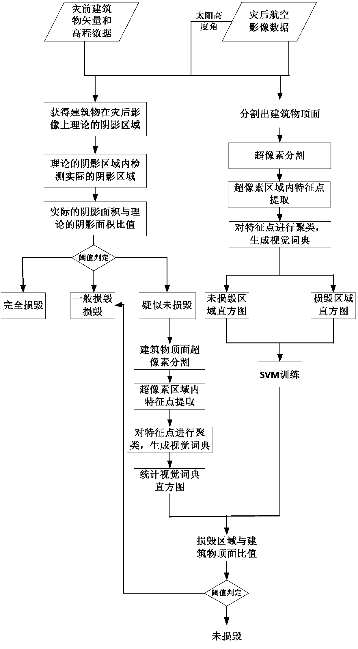
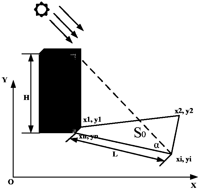
[0052] The aerial image building damage detection method under the fusion of building shadow and texture features provided by the present invention is to first estimate the theoretical shadow area of ​​the building on the image by using the vector data and elevation data of the building before the disaster and the sun altitude angle, and then In the shadow theory area, the actual shadow is detected by the constrained color invariance, and the actual shadow area of ​​the building is obtained. Then, the damage level of the building is obtained accordin...


PUM


Abstract

The invention discloses a method for detecting building damage in aerial images based on shadow and texture features. Firstly, the theoretical shadow area of ​​the building on the image is estimated by using the pre-disaster building vector data, elevation data and solar elevation angle, and then In the theoretical area, the actual shadow is detected by using the constrained color invariance to obtain the actual shadow area of ​​the building, and then the building damage level is obtained according to the area ratio between the actual shadow area and the theoretical shadow area, which is divided into complete damage, general damage and suspected Intact. Finally, for buildings that are suspected to be intact, use the bag of visual words model to detect the top surface to further determine whether the building is damaged. The invention combines the shadow information (height) and the top surface information (texture) of the building to perform detection, avoids registration difficulties in traditional multi-data fusion, and improves the accuracy of building damage detection.

Description

Technical field [0001] The invention belongs to the technical field of remote sensing image application, and in particular relates to a building damage detection method in aerial images that combines building shadow and texture features. Background technique [0002] Natural disasters have caused huge losses to human lives and property for a long time, and are a huge obstacle to human survival and development. Remote sensing technology has the characteristics of short revisit period, large detection range, and high data comprehensiveness, which provides a favorable means for disaster monitoring and evaluation. With the development of various monitoring methods and high-tech, traditional disaster detection and evaluation have gradually developed from qualitative statistical evaluation to quantitative fine evaluation. Buildings are the core elements of people's production and life. The detection and extraction of damage information after natural disasters are of great significance...

Claims


Application Information

Patent Timeline
Patent Type & Authority Patents(China)
IPC IPC(8): G06T7/00G06T7/10G06K9/62
CPCG06T7/0002G06T2207/20081G06T2207/10032G06F18/23213G06F18/2411
Inventor 眭海刚涂继辉吕枘蓬冯文卿马国锐孙开敏
Owner WUHAN UNIV
Why Eureka
Try Eureka