A Terrain Display Method Based on Terrain Database

A terrain display and database technology, applied in image data processing, 2D image generation, instruments, etc., can solve problems such as harassing alarms, not really put into use, and immature, and achieve the effect of increasing trust.

Active Publication Date: 2018-07-31
COMAC +1
View PDF4 Cites 0 Cited by
  • Summary
  • Abstract
  • Description
  • Claims
  • Application Information

AI Technical Summary

Problems solved by technology

The terrain display focusing on the vertical profile has been applied in operation, and there has been continuous research on 3D terrain display, but it is not yet mature and has not been put into use
[0003] In the prior art, whether it is a mature horizontal terrain display or a vertical profile terrain display, there is a problem: when the aircraft is flying in a mountainous area, especially when flying close to the terrain, or at a special airport according to RNP (RequiredNavigation Performance: precision navigation technology ) when flying a special route, the traditional warning method is prone to harassing warnings
This will cause the aircraft to lose the predictive terrain collision avoidance warning function during this terrain suppression period

Method used


Image

  • A Terrain Display Method Based on Terrain Database
  • A Terrain Display Method Based on Terrain Database

Examples


Embodiment Construction

[0026] In order to better illustrate the terrain display method based on the terrain database according to the present invention, it will be described in detail below with reference to the accompanying drawings.

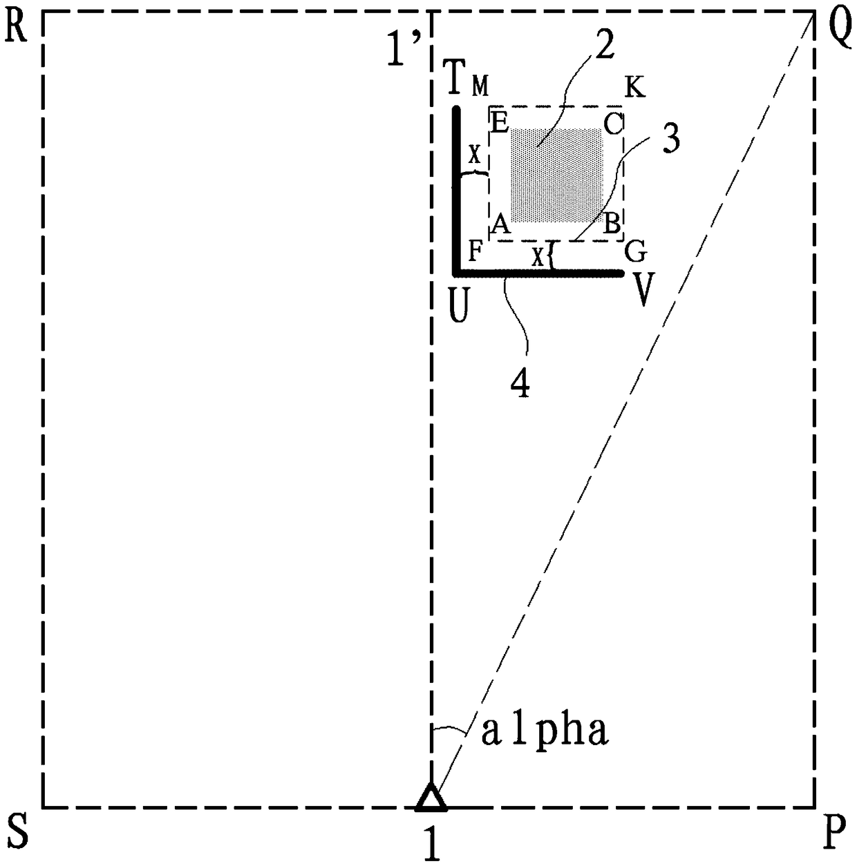
[0027] Such as figure 1 In the horizontal projection diagram shown, the aircraft is flying steadily at a certain altitude (height and height redundancy are not shown in the projection diagram), and a position sensor for measuring latitude and longitude coordinates is used. The position sensor can be a GPS system to measure The latitude and longitude coordinates (J, W) of the position 1 of the aircraft in space, and use the altitude sensor to measure the height H of the aircraft in flight in space. At this time, based on the horizontal plane of the flying height H where the aircraft is located, set the upward redundancy H1, the downward redundancy H2, the left horizontal redundancy L1, the right horizontal redundancy L2, and the front horizontal observation distance D...


PUM


Abstract

The present invention relates to a kind of terrain display method based on terrain database, comprising the following steps: (a) measuring the latitude and longitude coordinates of the aircraft in flight and the altitude H of space; (b) taking the horizontal plane of the flight altitude H where the aircraft is located as Benchmark, set upward highly redundant H1, downward highly redundant H2, leftward horizontally redundant L1, rightward horizontally redundant L2, and front horizontal observation distance D, thus forming a closed space; (c) in highly redundant Reasonably stratify within the range, and use the terrain database to obtain the terrain lattices in the horizontal plane of each height; (d) superimpose the terrain lattices in the horizontal plane of each selected height, and the formed connection of the point closest to the aircraft is The line is the contour line of the terrain, which is used as the safe boundary of the aircraft flight. The resulting terrain contour can play a role in terrain warning, especially suitable for special terrain, and can provide accurate and reliable terrain warning information during the suppression of terrain by aircraft.

Description

technical field [0001] The invention relates to a topographic display method based on a topographic database, in particular to a display method that provides clear and reliable topographical warning information by means of topographic contour lines. Background technique [0002] Currently, TAWS (Terrain awareness and warning system: Terrain Awareness and Warning System) is used in civil aviation to identify dangerous terrain information. The terrain display focusing on the vertical profile has been applied in operation, and there has been continuous research on 3D terrain display, but it is not yet mature and has not been put into use. [0003] In the existing technology, whether it is a mature horizontal terrain display or a vertical profile terrain display, there is a problem: when the aircraft flies in the mountainous area, especially when flying close to the terrain, or in a special airport according to RNP (RequiredNavigation Performance: precision navigation technology...

Claims


Application Information

Patent Timeline
Patent Type & Authority Patents(China)
IPC IPC(8): G06T11/00
Inventor 吴琛谢梦涛周贵荣方习高汤华余亮郑智明
Owner COMAC
Why Eureka
Try Eureka