Composite geological map automated cartographic generalization method

An automatic synthesis, geological map technology, applied in the field of geological information, can solve problems such as no practical value, and achieve the effect of improving speed

Active Publication Date: 2015-05-06
CHINA UNIV OF GEOSCIENCES (WUHAN) +1
View PDF5 Cites 11 Cited by
  • Summary
  • Abstract
  • Description
  • Claims
  • Application Information

AI Technical Summary

Problems solved by technology

However, the technology that can realize the automatic synthesis of geological maps in a digital environment, shorten the production cycle of geological maps of different scales associated with maps, and realize the integration and rapid update of geological map databases of multiple scales has not yet been seen. Many exploratory The results are not yet of practical value

Method used


Image

  • Composite geological map automated cartographic generalization method
  • Composite geological map automated cartographic generalization method
  • Composite geological map automated cartographic generalization method

Examples


Embodiment Construction

[0028] In order to make the objectives, technical solutions and advantages of the present invention clearer, the present invention will be further described in detail below in conjunction with embodiments. It should be understood that the specific embodiments described here are only used to explain the present invention, but not to limit the present invention.

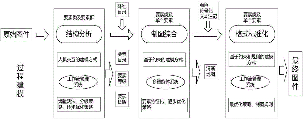
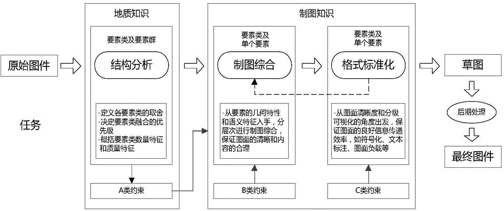
[0029] The automatic synthesis method of geological map mapping provided by the present invention is to realize the automatic synthesis of the geological map mapping process through three stages: source geological map structure analysis, original geological map mapping synthesis and target geological map format standardization.

[0030] The specific operation steps and operation contents are as follows, such as figure 1 Shown:

[0031] 1. Source geological map structure analysis stage

[0032] At this stage, the input data is generally geological thematic data, such as faults and lithological units, and topographic maps are us...


PUM


Abstract

The invention discloses a composite geological map automated cartographic generalization method. The method specifically comprises the following steps: forming a class A constraint for determining a map surface geological factor class, a factor group and spatial and semantic relationship thereof at a source geological map structure analysis stage according to characteristics such as use, a type, a proportional scale, a cartographic region and geological data of the geological map automated cartographic generalization and an actual working flow; forming multiple intelligent bodies by following the class A and class B constraints at a source geological map cartographic generalization stage, and performing generalization operation of the geological map by adopting different operations and operators for different levels of geological map objects; performing standardization processing on the geological map data obtained by the cartographic generalization stage according to a class C constraint at a target geological map format standardization stage to obtain a geological map which conforms to a drawing standard and has good vision expression. According to the method, the problem of consideration of a geometric shape and semantic information in the geological map automated cartographic generalization is effectively solved, and the speed, efficiency and accuracy of the geological map cartographic generalization are effectively improved.

Description

Technical field [0001] The invention relates to the technical field of geological information, in particular to a method for automatic synthesis of composite geological map mapping. Background technique [0002] The automatic comprehensive technology of geological map mapping is the core technology for the compilation and drawing of small and medium-scale geological maps, and is a research hotspot and frontier subject in geological research and various geological survey fields. At present, the automatic synthesis technology of general map cartography is relatively mature, but the automatic synthesis technology of geological map cartography is still under exploration. [0003] The mapping process from large-scale geological maps, to medium-scale geological maps, and then to small-scale geological maps is a process of information extraction and synthesis, referred to as the comprehensive process of geological mapping. Traditional geological mapping and mapping are integrated, us...

Claims


Application Information

Patent Timeline
Patent Type & Authority Applications(China)
IPC IPC(8): G06F17/30
CPCG06F16/29
Inventor 吴冲龙张军强刘刚何珍文翁正平张志庭张夏林李章林田宜平
Owner CHINA UNIV OF GEOSCIENCES (WUHAN)
Why Eureka
Try Eureka