Radial basis function based GIS (Geographic Information System) vector data reversible decryption method

A basis function and deciphering technology, applied in the field of geographic information security, which can solve the problems of discontinuity of first derivative, non-smooth deformation of deformation, difficulty in interpolation and calculation, etc.

Inactive Publication Date: 2014-10-01
NANJING NORMAL UNIVERSITY
View PDF3 Cites 11 Cited by
  • Summary
  • Abstract
  • Description
  • Claims
  • Application Information

AI Technical Summary

Problems solved by technology

The adjacent blocks of the block transformation model are transformed by different transformation parameters. Although the function is continuous at the edge, the first-order derivative is discontinuous, which makes the deformation not smooth.
Casado [5] It is proposed to maintain t...

Method used


Image

  • Radial basis function based GIS (Geographic Information System) vector data reversible decryption method
  • Radial basis function based GIS (Geographic Information System) vector data reversible decryption method
  • Radial basis function based GIS (Geographic Information System) vector data reversible decryption method

Examples


Embodiment Construction

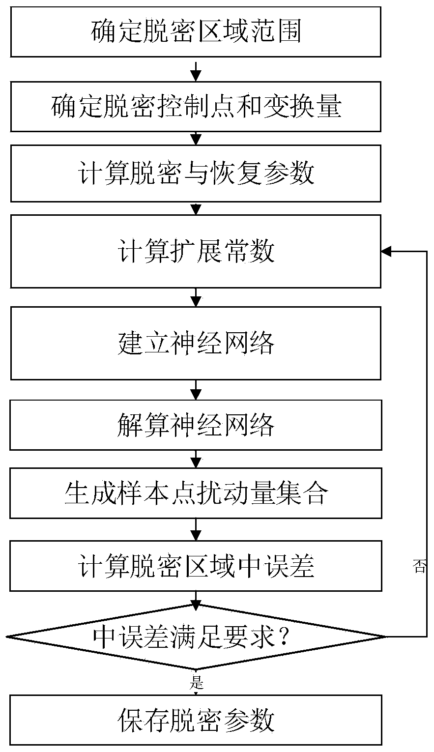
[0062] The present invention will be described in further detail below in conjunction with the accompanying drawings and embodiments.

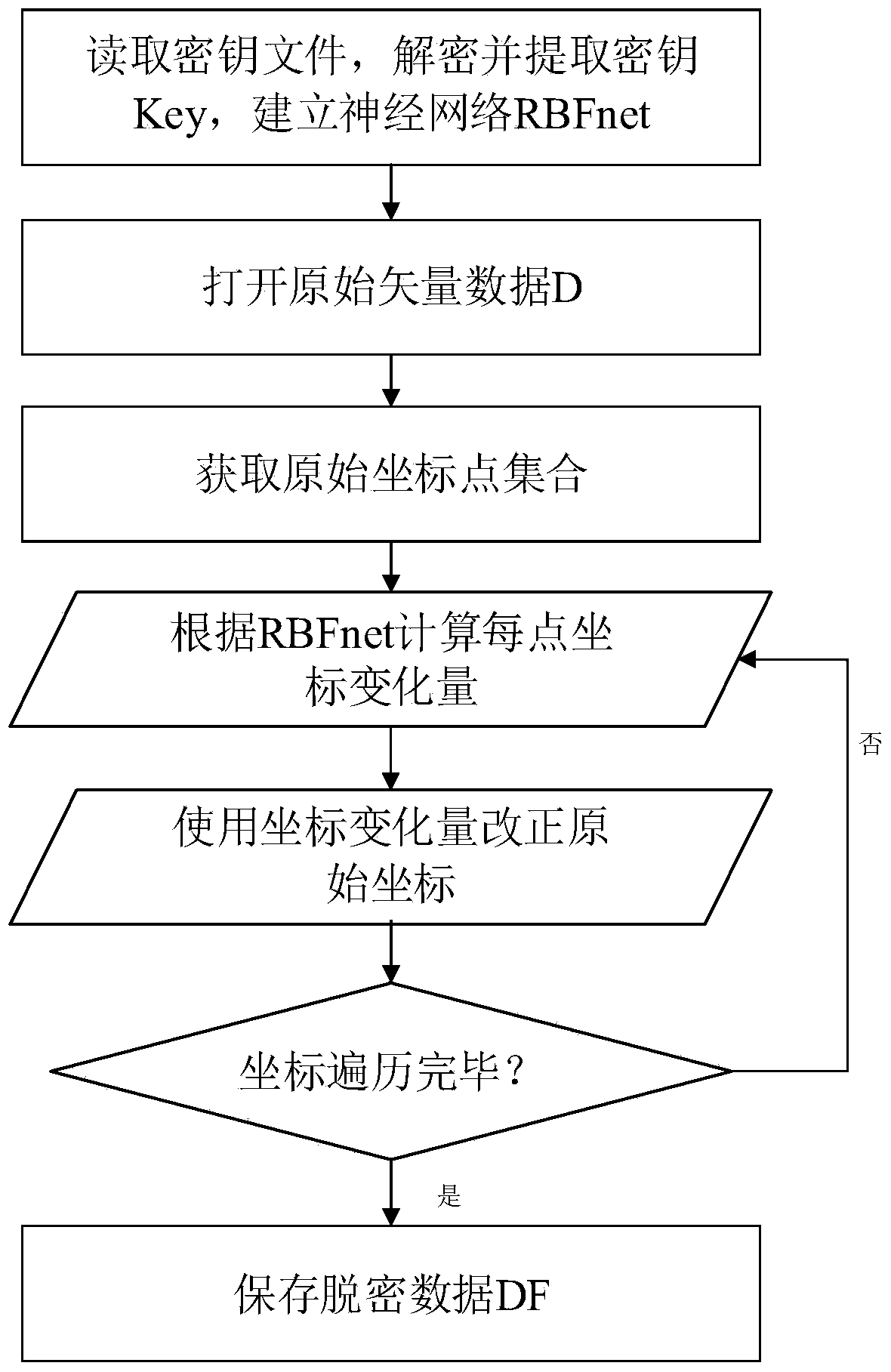
[0063] In this embodiment, the shapefile format vector data is selected, and the data is read, decrypted and restored, and the present invention is further described in detail. This embodiment selects the shp surface layer data (such as image 3 ) as the original vector data.

[0064] (1) Key generation process

[0065] Step 11: Determine the declassification range, and input the minimum circumscribed rectangle R of the declassification area. The coordinates of the lower left corner of R are (122495.732400, 142744.631250), the coordinates of the upper right corner are (124508.231850, 144754.166800), and the length of the data in the X direction XL=2012.49945m, and the length of the Y direction YL=2009.53555m;

[0066] Step 12: Determine data control points and transformation values. Input the overall transformation amount of data offset=35...


PUM


Abstract

The invention discloses a radial basis function based GIS (Geographic Information System) vector data reversible decryption method. The radial basis function based GIS vector data reversible decryption method comprises step 1, the decryption processing process for GIS vector data, wherein the decryption processing process comprises control point selection, decryption transformation parameter generation and secret key saving; step 2, the decryption processing process for vector data, wherein the decryption processing process comprises secret key reading, original vector data decryption processing and the like; step 3, the recovery processing process for the decrypted vector data, wherein the recovery processing process comprises key reading, decrypted vector data recovery and the like. The radial basis function based GIS vector data reversible decryption method is gradual, safe, reversible and the like and suitable for the characteristic point based GIS vector data decryption and can be applied to the public release of the GIS vector data.

Description

technical field [0001] The invention belongs to the field of geographic information security, and in particular relates to a reversible decryption method for GIS vector data based on a radial basis function. Background technique [0002] "Regulations on the Scope of State Secrets in Surveying and Mapping Management", "Supplementary Regulations on the Display of Public Map Contents (Trial)" and "Regulations on the Public Display of Basic Geographic Information (Trial)" on the restrictions and confidentiality of public maps and geographic information Provisions have been made, and special emphasis has been placed on the confidentiality of the spatial location accuracy of basic geographic information and related elements. [0003] Ordinary facilities and sensitive facilities have different point accuracy index requirements. In the practice of decryption, the method of selecting control points is generally used for decryption. Usually, the water system, the intersection of roa...

Claims


Application Information

Patent Timeline
IPC IPC(8): G06F21/60
CPCG06F21/6209
Inventor 高隆杰周卫王芙蓉
Owner NANJING NORMAL UNIVERSITY
Why Eureka
Try Eureka