
Cirrus cloud recognition method based on satellite 2.0-micrometer channel data

A micron channel and satellite technology, applied in the field of satellite atmospheric remote sensing, can solve problems such as inability to effectively identify high-altitude cirrus clouds and inversion result errors, and achieve the effect of fast and effective technical methods

Inactive Publication Date: 2014-07-16
INST OF REMOTE SENSING & DIGITAL EARTH CHINESE ACADEMY OF SCI
View PDF4 Cites 8 Cited by
  • Summary
  • Abstract
  • Description
  • Claims
  • Application Information

AI Technical Summary

Problems solved by technology

[0003] However, the observation data of the short-wave near-infrared channel is easily affected by clouds, and cloud scattering will bring huge errors to the inversion results
Low-level visible cloud pixels are generally removed through the cloud mask data of the visible light channel, but this method cannot effectively identify the existence of high-altitude cirrus clouds

Method used


Image

  • Cirrus cloud recognition method based on satellite 2.0-micrometer channel data
  • Cirrus cloud recognition method based on satellite 2.0-micrometer channel data
  • Cirrus cloud recognition method based on satellite 2.0-micrometer channel data

Examples


Embodiment Construction

[0020] specific implementation plan

[0021] The following describes in detail in conjunction with the accompanying drawings and embodiments.

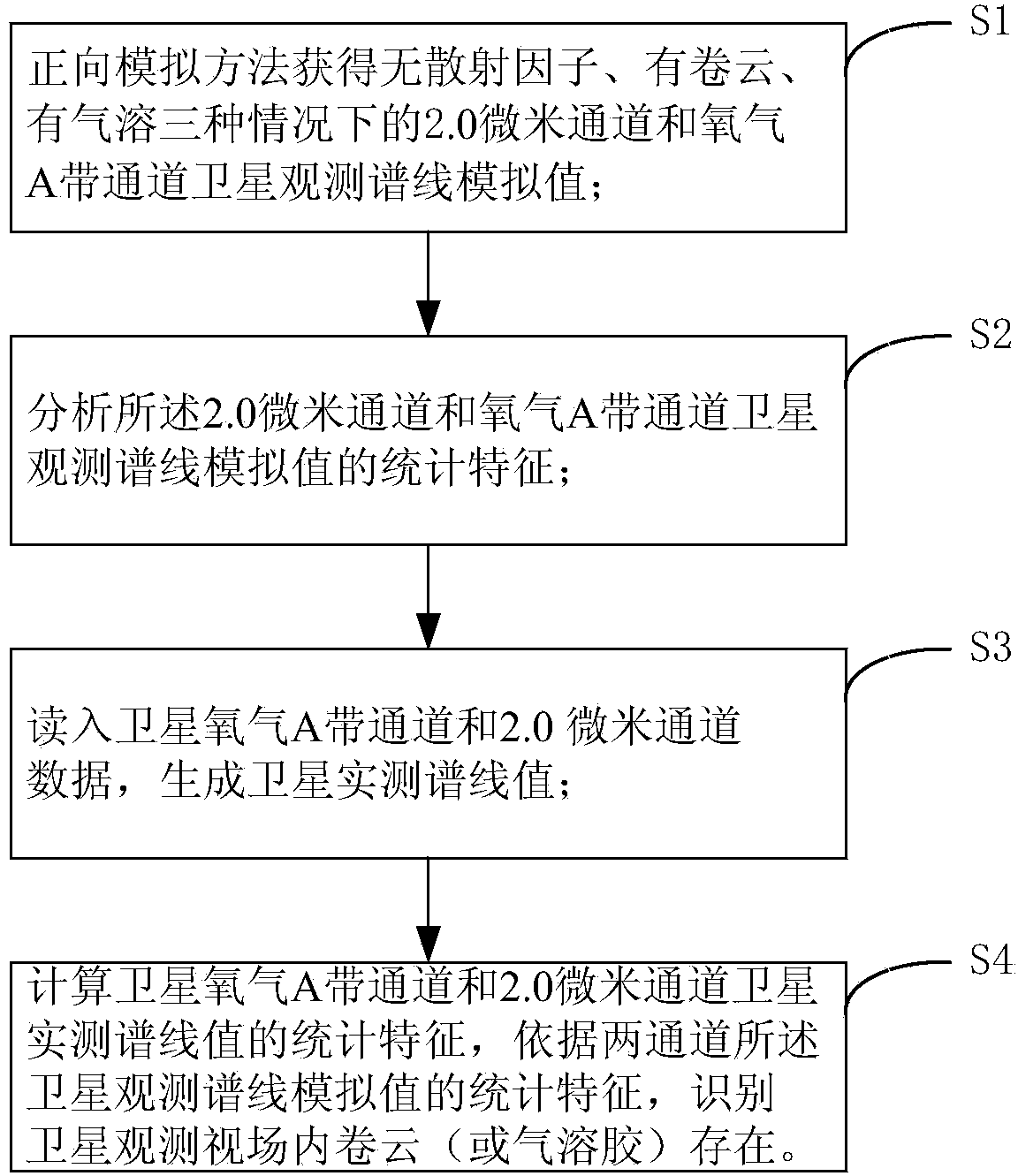
[0022] Such as figure 1 As shown, according to a kind of cirrus cloud identification method step based on satellite 2.0 micron channel data of the present invention comprises:

[0023] Step S1, according to the GOSAT satellite data, use the forward model to simulate the 2.0 micron channel and the oxygen A band channel in the observation field without scattering factors and with scattering factors (including when there are cirrus clouds and aerosols) under different observation geometric conditions Satellite observation spectral line simulation value;

[0024] Step S1 further includes:

[0025] S1.1. According to the characteristics of GOSAT satellite data, forwardly simulate the 2.0 micron channel under different observation geometric conditions, and the satellite observation spectrum line simulation value when there is no scatterin...


PUM


Abstract

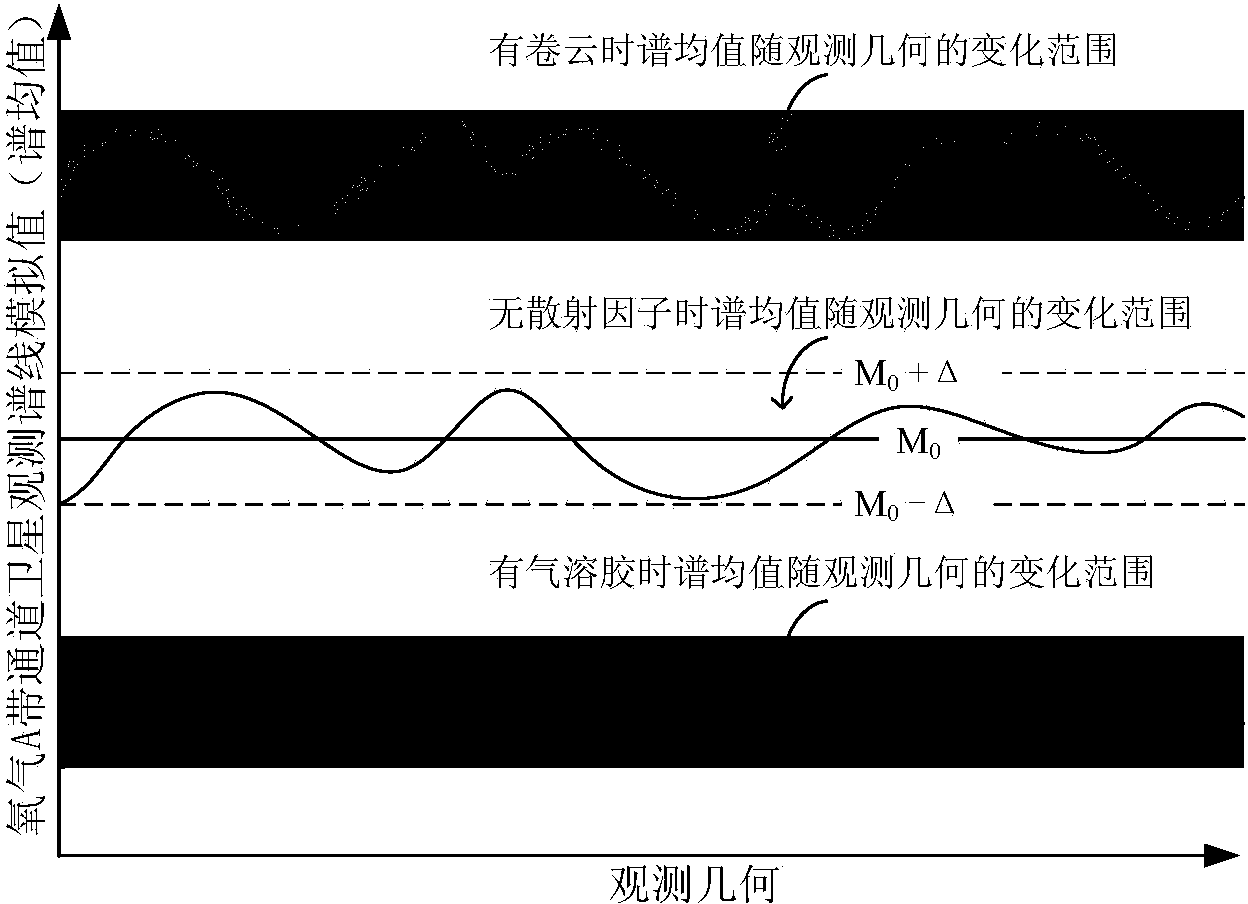
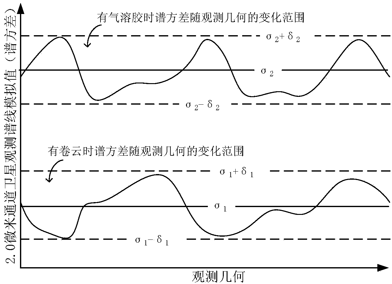
The invention discloses a cirrus cloud recognition method based on satellite 2.0-micrometer channel data. The cirrus cloud recognition method comprises the steps of simulating satellite observation spectral line simulation values of a 2.0-micrometer channel and an oxygen A belt channel free of scattering factors and with cirrus cloud and aerosol under different observation geometrical conditions through a forward model according to satellite data; analyzing statistical characteristics of the satellite observation spectral line simulation values of the 2.0-micrometer channel and the oxygen A belt channel, wherein the statistical characteristics include spectrum mean values and spectrum variances; reading data of the satellite oxygen A belt channel and the 2.0-micrometer channel to generate satellite actually-measured spectral line values; performing calculation on the statistical characteristics of two satellite actually-measured spectral line values, and contrasting statistical laws of the two satellite actually-measured spectral line values to recognize whether cirrus cloud exists in a satellite observation field of view: judging whether influence of scattering shadow exists according to the spectrum mean value of the satellite actually-measured spectral line value of the oxygen A belt channel and determining the cirrus cloud or the aerosol through the spectrum variance of the satellite actually-measured spectral line value of the 2.0-micrometer channel if influence of scattering shadow exists. By means of the cirrus cloud recognition method based on satellite 2.0-micrometer channel data, the problem of scattering influence of the cirrus cloud during CO2 remote sensing retrieval of a short-wave near-infrared satellite can be solved quickly and effectively.

Description

technical field [0001] The invention relates to the technical field of satellite atmospheric remote sensing, in particular to a cirrus identification method in satellite remote sensing data inversion. Background technique [0002] According to the IPCC, the rapid increase in the concentration of atmospheric carbon dioxide in the past century has led to global warming, and the concentration and spatial distribution of carbon dioxide are one of the main uncertain factors in the assessment of global climate change. Since the main source of carbon dioxide is concentrated in the near-surface atmosphere, the distribution of carbon dioxide concentration in the bottom atmosphere has become a research hotspot. The traditional ground-based observation network is sparsely distributed, and its observation data cannot meet the application requirements. Satellite remote sensing technology can make up for the shortcomings of limited ground-based observation data. In the 1970s, the United ...

Claims


Application Information

Patent Timeline
IPC IPC(8): G01S17/95
CPCG01S17/95Y02A90/10
Inventor 邹铭敏陈良富陶金花张莹范萌苏林
Owner INST OF REMOTE SENSING & DIGITAL EARTH CHINESE ACADEMY OF SCI
Learn More