Warning and intervention method of crop growth period based on remote sensing and massive climate information
A technology for climate information and crops, applied in the fields of instruments, data processing applications, computing, etc., can solve problems such as blank and insufficient functions, and achieve the effect of wide monitoring range, reducing adverse effects, and solving problems.
- Summary
- Abstract
- Description
- Claims
- Application Information
AI Technical Summary
Problems solved by technology
Method used
Image
Examples
Embodiment
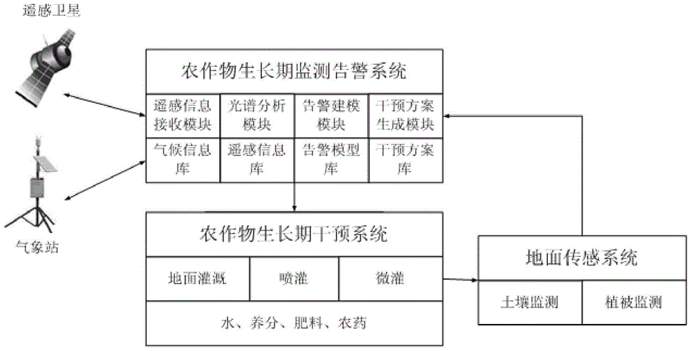
[0045] As shown in 1-3, a crop growth period warning and intervention method based on remote sensing and massive climate information is to establish a crop growth period warning model through remote sensing technology, sensor technology, and mathematical modeling technology combined with historical remote sensing information and historical climate information , and then realize the method of remotely monitoring the growth of crops and performing alarm and intervention; including the following steps:
[0046] Step 1: Establish a crop growth period monitoring and warning system on the remote management center platform, which includes a data server, a remote sensing information receiving module, a spectral analysis module, an alarm modeling module, and an intervention plan generation module; Intervention systems and ground sensing systems;
[0047] Step 2: Collect basic data and transmit it to the data server for storage. The basic data includes the historical remote sensing info...
example 1
[0060] The system regularly obtains remote sensing image information from remote sensing satellites, conducts crop identification, soil moisture analysis, vegetation moisture content analysis and surface temperature analysis, combines real-time climate information and forecast information, uses drought models to analyze and process, and judges whether the current crops are It is in a drought state, and a drought degree index is given. If several drought indexes exceed the warning value, an alarm is required. Find an intervention plan that matches the drought situation in the intervention plan library, and start the crop intervention system to implement the intervention. After the intervention, start the ground sensing system to monitor the soil condition and vegetation condition and send back the data, and further improve the intervention plan through the analysis and evaluation of the intervention effect.
example 2
[0062] The system regularly acquires remote sensing image information from remote sensing satellites, and performs crop identification, spectral characteristic curve drawing, and crop leaf loss analysis on it. Combined with real-time climate information and forecast information, the pest model is used for analysis and processing to determine whether the current crops have pests and diseases. And give the pest severity index. If the pest index exceeds the warning value, an alarm is required. Find the intervention plan that matches the pest situation in the intervention plan library, and start the crop intervention system to implement the intervention. After the intervention, start the ground sensing system to monitor the soil condition and vegetation condition and send back the data, and further improve the intervention plan through the analysis and evaluation of the intervention effect.
PUM
 Abstract
Description
Claims
Application Information
 - R&D
- Intellectual Property
- Life Sciences
- Materials
- Tech Scout
- Unparalleled Data Quality
- Higher Quality Content
- 60% Fewer Hallucinations
Browse by: Latest US Patents, China's latest patents, Technical Efficacy Thesaurus, Application Domain, Technology Topic, Popular Technical Reports.
© 2025 PatSnap. All rights reserved.Legal|Privacy policy|Modern Slavery Act Transparency Statement|Sitemap|About US| Contact US: help@patsnap.com


