Construction method for reforming overall topography by determining elevations by adopting garden path foundation trench excavation
A technology of terrain modification and construction method, applied in basic structure engineering, roads, roads, etc., can solve the problems of failing to meet construction requirements, increasing construction difficulty, and difficulty in excavating foundation grooves, saving manpower and material resources, and avoiding construction sites. The effect of confusion and reduction of construction difficulty
- Summary
- Abstract
- Description
- Claims
- Application Information
AI Technical Summary
Problems solved by technology
Method used
Image
Examples
Embodiment 1
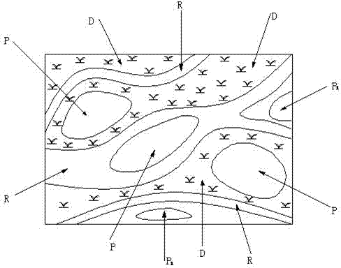
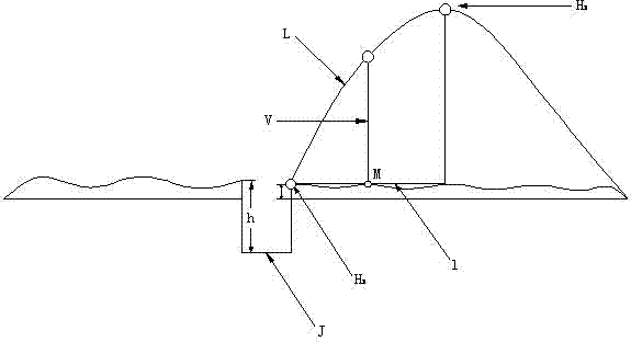
[0019] Embodiment one: with reference to attached figure 1 , 2 The construction method of the overall terrain transformation using the excavation of the garden subgrade groove to determine the elevation is shown. The construction method includes the following steps: (1) Accurately calibrate the garden construction scope: make preparations before excavation, and according to the construction Drawings calibrate the overall construction scope; (2) survey of the construction point, clear the table and remove obstacles: use survey instruments to survey and make statistics on the geology of the construction area, and remove and deal with the obstacles on the ground in the construction area; (3) Construction, surveying personnel and machinery equipment: according to the construction scale, the number of construction personnel, excavators, loaders, etc. should be reasonably allocated; (4) Construction survey and stake out of the garden road, to determine the elevation of the slope-mak...
Embodiment 2
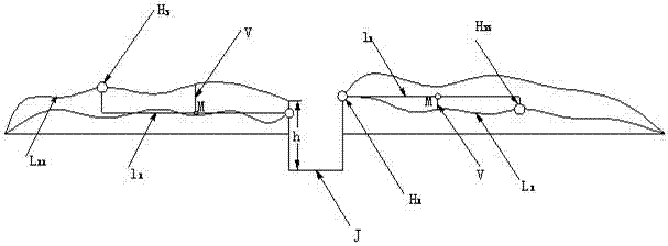
[0020] Embodiment 2: The difference from Embodiment 1 is that in the step (4) during terrain shaping, when the roadbed groove J is excavated to the terrain shaping point P 1 , select one of the connection elevation points H between the earthwork and the garden road determined after the excavation of the foundation trench J in step (5) 1 and one of the terrain transformation points determined in step (6) is the terrain shaping elevation point H 3 , according to H 1 with H 3 height difference d between two points 1 and the horizontal distance line l 1 Determining the terraformation curve L 1 , if both sides of the garden embankment groove J need to be reshaped, according to the above method, measure and mark the two sides respectively, and determine two reconstruction curves L 1 and L 11 , and L 11 The terrain shaping elevation point H 3 , L 1 The terrain shaping elevation point H 33 , if H 33 >H 3 , will be located at H 33 The earthwork at the place is directly fil...
PUM
 Abstract
Description
Claims
Application Information
 - R&D Engineer
- R&D Manager
- IP Professional
- Industry Leading Data Capabilities
- Powerful AI technology
- Patent DNA Extraction
Browse by: Latest US Patents, China's latest patents, Technical Efficacy Thesaurus, Application Domain, Technology Topic, Popular Technical Reports.
© 2024 PatSnap. All rights reserved.Legal|Privacy policy|Modern Slavery Act Transparency Statement|Sitemap|About US| Contact US: help@patsnap.com


