Portable mobile section speed measurement realization method and system based on satellite positioning system and GIS (Geographic Information System)
A technology of satellite positioning system and interval speed measurement, applied in satellite radio beacon positioning system, traffic control system, radio wave measurement system, etc. High accuracy, low control cost, flexible structure
- Summary
- Abstract
- Description
- Claims
- Application Information
AI Technical Summary
Problems solved by technology
Method used
Image
Examples
Embodiment Construction
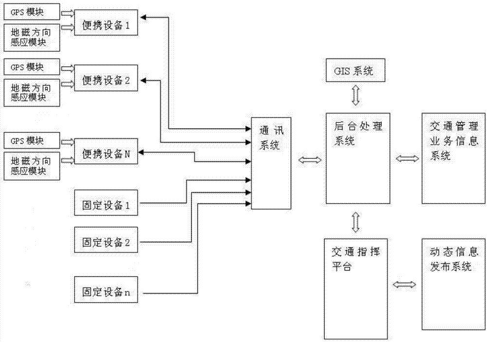
[0033] In order to effectively solve the limitations of the control range and control effect of the current traditional point speed measurement method on the road, the fashionable interval speed measurement system has been gradually adopted due to its wide control range and scientific control. Once the fixed bayonet or speed measuring equipment is installed and relocated, the coil construction must be re-conducted, and the interval distance identification must be re-applied, resulting in extremely cumbersome relocation. Moreover, it cannot be widely used due to the high cost of equipment installation and equipment cost. The present invention breaks through the limitations of existing point speed measurement and fixed interval speed measurement, and adopts dynamic portable information collection terminals to form an interval speed measurement system. It has the characteristics of flexible interval networking, flexible management and control focus, high equipment utilization eff...
PUM
 Abstract
Description
Claims
Application Information
 - R&D
- Intellectual Property
- Life Sciences
- Materials
- Tech Scout
- Unparalleled Data Quality
- Higher Quality Content
- 60% Fewer Hallucinations
Browse by: Latest US Patents, China's latest patents, Technical Efficacy Thesaurus, Application Domain, Technology Topic, Popular Technical Reports.
© 2025 PatSnap. All rights reserved.Legal|Privacy policy|Modern Slavery Act Transparency Statement|Sitemap|About US| Contact US: help@patsnap.com


