
High-precision vehicle positioning method for fusing multi-source information under GPS (global positioning system) blind area and device

A multi-source information and positioning method technology, which is applied in the field of high-precision vehicle positioning based on multi-source information fusion in GPS blind areas, can solve problems such as difficulty in adapting to maneuvering targets, inability to use GPS positioning, and GPS signal blind areas

Active Publication Date: 2014-01-08
CHANGAN UNIV
View PDF3 Cites 56 Cited by
  • Summary
  • Abstract
  • Description
  • Claims
  • Application Information

AI Technical Summary

Problems solved by technology

Among them, GPS is the most widely used positioning technology at present. The existing intelligent transportation system generally adopts the GPS method for vehicle positioning, but this method is difficult to meet the application requirements of the future Internet of Vehicles. The main defects are as follows: (1) Low positioning accuracy
(2) There are GPS signal blind spots
When the vehicle is driving in mountainous highways, tunnels, and urban areas with dense buildings, the GPS signal is easily blocked. At this time, the vehicle will enter the GPS signal blind spot and cannot use GPS for positioning
(3) Low output frequency
However, its technical shortcomings are also very obvious, mainly in: (1) The production cycle of the reference map is too long; (2) When faced with a large area where the road surface characteristics do not change significantly, the road matching navigation system will be unable to locate. Unusable or greatly reduced navigation accuracy; (3) Difficult to adapt to maneuvering targets
[0006] Due to the shortcomings of adaptability and efficiency in the road matching algorithm, most of the current high-precision vehicle positioning methods based on fusion ideas use GPS and INS as fusion information sources. ideal effect

Method used


Image

  • High-precision vehicle positioning method for fusing multi-source information under GPS (global positioning system) blind area and device
  • High-precision vehicle positioning method for fusing multi-source information under GPS (global positioning system) blind area and device
  • High-precision vehicle positioning method for fusing multi-source information under GPS (global positioning system) blind area and device

Examples


Embodiment

[0104] The inventor has carried out experiment with the inventive method and GPS positioning method, and experimental process is as follows:

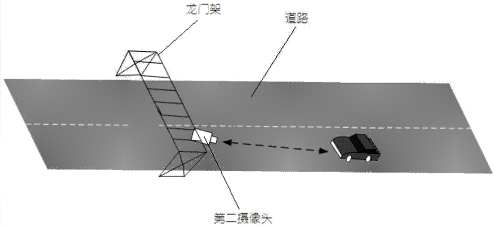
[0105] The inventor conducted a test in a certain automobile proving ground. Using the above method, a gantry and a second camera were installed every 5km on the runway, and a gyroscope and an accelerometer were installed inside the vehicle to obtain the angular rate and acceleration, and installed on the outer section of the vehicle The first camera shoots the road surface, and the test is carried out using the above method. The final test results are as follows: Figure 6 shown. The line marked with a triangle is the trajectory obtained by this method, and the line marked with a circle is the actual trajectory of the vehicle. From Figure 6 It can be seen that the trajectory diagram of the triangle line and the circle line is almost completely consistent, which proves that the positioning effect is quite ideal, and the actual effect...


PUM


Abstract

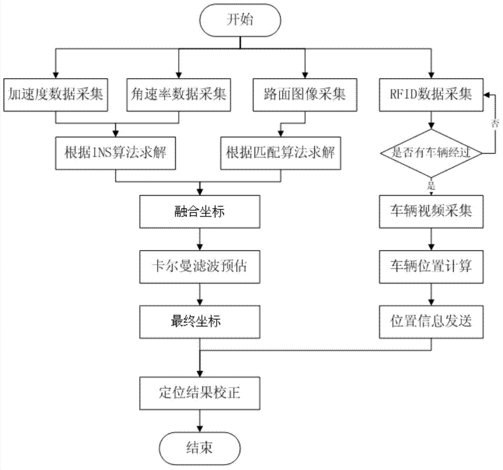
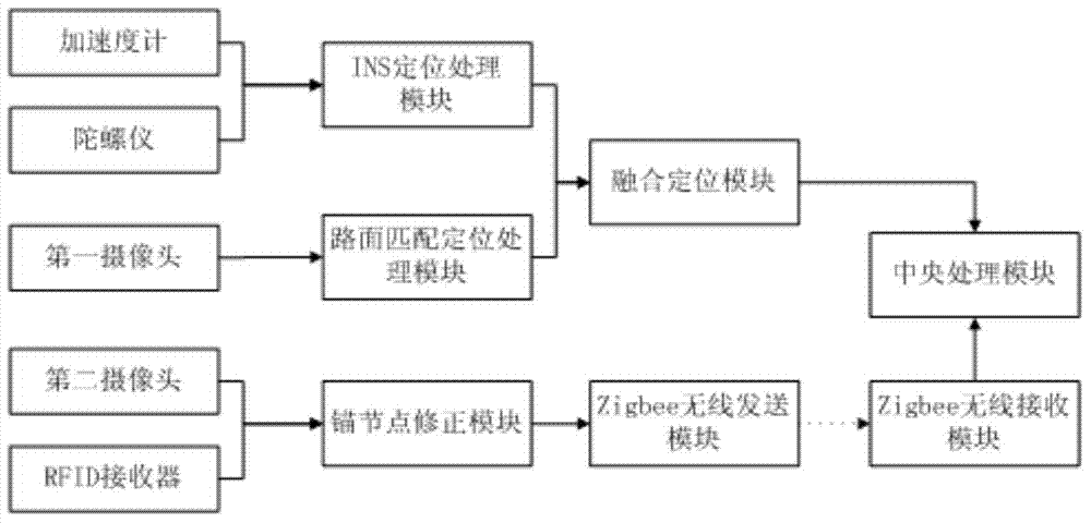
The invention discloses a high-precision vehicle positioning method for fusing multi-source information under a GPS (global positioning system) blind area and a device. By a strap-down matrix algorithm of the method, INS (inertial navigation system) vehicle position information and position information obtained by a pavement matching technology are calculated according to angular rate information output by a gyroscope and acceleration information output by an accelerometer and are fused by a kalman filtering algorithm to output final fused positioning information. As an INS positioning algorithm has an accumulated error, vehicle position information is recalibrated by arranging an anchor node beside a road. According to the method, stable and reliable high-precision vehicle position information can be obtained; the method is suitable for non-GPS-signal environments such as urban roads with dense buildings, mountain areas and tunnels.

Description

technical field [0001] The invention belongs to the technical field of traffic detection and vehicle active positioning, and relates to a high-precision vehicle positioning method in a GPS blind area, in particular to a high-precision vehicle positioning method based on multi-source information fusion in a GPS blind area. Background technique [0002] The detection of high-precision vehicle location information is an important parameter in the field of Internet of Vehicles, especially in complex environments such as mountainous areas and tunnels, where high-precision vehicle location information becomes particularly important. Therefore, it is of great significance to obtain the high-precision position information of the vehicle in the GPS blind area. [0003] At present, the commonly used high-precision vehicle acquisition methods mainly include: GPS positioning, inertial navigation technology, road surface matching technology, etc. Among them, GPS is the most widely used ...

Claims


Application Information

Patent Timeline
IPC IPC(8): G01C21/24
CPCG01C21/30
Inventor 赵祥模徐志刚张立成程鑫白国柱周经美任亮
Owner CHANGAN UNIV
Learn More