Positioning, navigating and locus plotting apparatus

A technology for positioning navigation and plotters, used in navigation, surveying and mapping, navigation, instruments, etc.

Inactive Publication Date: 2013-12-11
CHONGQING SAFETY STAND TECH
View PDF5 Cites 9 Cited by
  • Summary
  • Abstract
  • Description
  • Claims
  • Application Information

AI Technical Summary

Problems solved by technology

[0002]Many underground mines in China have numerous roadways. To obtain the distribution maps of these complex roadways, there are currently two main methods: one is to use a professional total station for on-the-spot measurement and drawing , its advantage is high measurement accuracy, the disadvantage is that it is expensive, requires professionals to use it, and can only be measured within the visible range. Mine roadways are often criss-crossed and there are many turns. To draw a complete mine roadway distribution map, The workload of surveying and mapping is very large, and it is not suitable for surveying at any time. The data collected by the total station measurement needs to be input into the computer and drawn into a CAD map with professional software. The first is to use a ground satellite navigator, the principle of which is to use the wireless signal data transmitted by multiple navigation satellites to calculate and locate, but it can only be used on the open ground where satellite signals can be received, and cannot be used in mine roadways

Method used


Image

  • Positioning, navigating and locus plotting apparatus
  • Positioning, navigating and locus plotting apparatus

Examples


Embodiment Construction

[0012] The present invention will be described in further detail below in conjunction with specific embodiments and accompanying drawings.

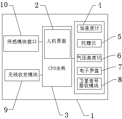
[0013] a kind of like figure 1 The shown positioning navigation and trajectory plotter includes a casing 1 and a man-machine interface 2 arranged on the surface of the casing 1, and also includes a CPU motherboard 3 arranged in the casing 1 and an accelerometer 4 connected thereto, a gyroscope 5, an air pressure Altimeter 6, electronic compass 7, satellite signal receiving module 8, wireless transceiver module 9 and sensor module interface 10 for gas sensor and device identification module to be connected, the positioning navigation and trajectory drawing are completed through accelerometer 4, gyroscope 5, etc. The barometric altimeter 6 can calculate the altitude change, the electronic compass 7 can detect the relative geomagnetic field direction deviation, and the CPU main board 3 comprehensively calculates these parameters, and the mu...


PUM


Abstract

The invention provides a positioning, navigating and locus plotting apparatus. The positioning, navigating and locus plotting apparatus comprises a shell and a human-machine interface arranged on the surface of the shell, and also comprises a CPU mainboard arranged in the shell, and an accelerometer, a gyroscope, an atmospheric pressure altimeter, an electron compass, a satellite signal reception module, a wireless transmit-receive module and sensing module interfaces for the switch-in of a gas sensor and an apparatus identifying module, which are connected with the CPU mainboard and are also arranged in the shell. The apparatus has a simple structure and a low price, can be used for ground positioning, navigating and locus plotting, can also be used for the positioning, navigating and locus plotting of places having no satellite signals and comprising mines, underground pipe networks and the like, can determine whether crossed mine mining is carried out or not in real time, and is a timely and effective crossing monitoring tool for mining industry resource monitoring departments, can be used for drawing a mine toxic gas distribution map and a mine apparatus distribution map, has the advantages of small size, light weight portability, use convenience, and no need of processional technologies and knowledge of users, and is suitable for large batch popularization.

Description

technical field [0001] The invention relates to a positioning navigation and trajectory plotter. Background technique [0002] Many underground mines in our country have many tunnels. To obtain the distribution maps of these complex tunnels, there are currently two main methods: one is to use a professional total station for on-the-spot measurement and drawing, which has the advantage of high measurement accuracy, but the disadvantage is that it is expensive and requires professional It can only be used by personnel, and can only be measured within the visible range. Mine roadways are often criss-crossed and have many turns. To draw a complete mine roadway distribution map, the surveying and mapping workload is very heavy, and it is not suitable for measurement at any time. Through the total station The data collected by the instrument measurement needs to be input into the computer and drawn into a CAD map with professional software. This kind of map is not suitable for the...

Claims


Application Information

Patent Timeline
Patent Type & Authority Applications(China)
IPC IPC(8): G01C21/00B43L13/00
Inventor 向武
Owner CHONGQING SAFETY STAND TECH
Why Eureka
Try Eureka