Eureka AIR delivers breakthrough ideas for toughest innovation challenges, trusted by R&D personnel around the world.

Embedded wireless intelligent sensor for geotechnical engineering monitoring

An intelligent sensor, geotechnical engineering technology, applied in the direction of instruments, signal transmission systems, sealed enclosures, etc., can solve the problem of low degree of automation of data acquisition and transmission, difficult real-time and accurate acquisition of data on the engineering site, real-time performance and monitoring frequency difficult to meet the requirements and other problems, to achieve the effect of low power consumption, flexible power supply, and high degree of automation

Inactive Publication Date: 2013-07-17
TIANJIN RES INST OF BUILDING SCI
View PDF4 Cites 5 Cited by
  • Summary
  • Abstract
  • Description
  • Claims
  • Application Information

AI Technical Summary

Problems solved by technology

In recent years, although the domestic geotechnical monitoring technology has been developed to a certain extent, its monitoring technology mainly focuses on the improvement and improvement of on-site monitoring equipment and data processing software, while the data acquisition and transmission automation in geotechnical monitoring still low
[0004] At present, in the process of geotechnical monitoring, the monitoring instrument is usually buried in the ground at the project site, and several signal lines are drawn out on the ground. The data collection work is basically completed by the monitoring personnel on-site instrument collection. The labor cost is too high, and it makes the The monitoring workload is heavy and time-consuming, and the real-time and monitoring frequency are also difficult to meet the requirements, especially in complex construction conditions and harsh monitoring conditions. It is more difficult to achieve real-time and accurate data collection

Method used


Image

  • Embedded wireless intelligent sensor for geotechnical engineering monitoring
  • Embedded wireless intelligent sensor for geotechnical engineering monitoring
  • Embedded wireless intelligent sensor for geotechnical engineering monitoring

Examples


Embodiment Construction

[0025] The present invention will be described in further detail below in conjunction with the accompanying drawings.

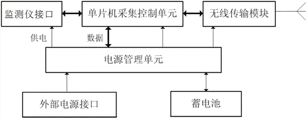
[0026] A wireless smart sensor for buried geotechnical engineering monitoring, such as figure 1 and figure 2 As shown, it is composed of a sealed box and its internal sensor circuit. An antenna and a quick-plug waterproof connector are installed on the sealed box. An antenna protective cover is provided outside the antenna to realize the protection function of the antenna. Connectors can be connected to monitors. The sensor circuit in the sealed box includes an acquisition control unit, a wireless transmission module, a power management unit, a battery, an external power interface and a monitor interface unit, and the power management unit is connected to the external power interface and the battery for power conversion and connected to the acquisition control unit , the wireless transmission module, and the interface unit of the monitoring instrument prov...


PUM


Abstract

The invention relates to an embedded wireless intelligent sensor for geotechnical engineering monitoring. The embedded wireless intelligent sensor is mainly characterized in that the embedded wireless intelligent sensor comprises a sealing box and an internal sensor circuit; the sensor circuit comprises a collecting and controlling unit, a wireless transmitting module, a power source managing unit, a storage battery and a monitor interface unit. The collecting and controlling unit is connected with the wireless transmitting module, the monitor interface unit and the power source managing unit respectively; the wireless transmitting module is connected with a field server through antennas mounted on the sealing box to realize a function of wireless transmission; and the monitor interface unit is connected with a monitor. The embedded wireless intelligent sensor is reasonable in design, realizes functions of automatic data collection and transmission for geotechnical monitoring, has the characteristics of high automaticity, convenience in networking, low cost and the like, can be widely used in the fields of stability monitoring on natural rock mass geography, side slope and support in ground works, underground tunnels and construction works.

Description

technical field [0001] The invention belongs to the field of geotechnical monitoring, in particular to a wireless intelligent sensor for buried geotechnical engineering monitoring. Background technique [0002] In the process of engineering construction, the stability of rock and soil is directly related to the life safety of the entire project and construction personnel. After engineering construction, people have changed the natural state of rock and soil, so it is more important to monitor and analyze the stability of rock and soil. If it is not handled properly, it will not only endanger the safety of the project itself, but also endanger the safety of adjacent structures and personnel, causing huge losses. Therefore, accurate, timely, comprehensive and systematic monitoring of geotechnical information plays an important role in engineering construction and after construction. Significance. [0003] Geotechnical automatic monitoring technology is a highly comprehensive...

Claims


Application Information

Patent Timeline
Patent Type & Authority Applications(China)
IPC IPC(8): G08C17/02H05K5/06
Inventor 王毅李斌王国伟魏成娟朱全斌
Owner TIANJIN RES INST OF BUILDING SCI
Why Eureka
Eureka Blog
Learn More