
Wind arrow field real-time measuring method based on satellite cloud pictures

A satellite cloud image and measurement method technology, applied in image analysis, measurement devices, image data processing and other directions, can solve the problems of low search algorithm efficiency, difficult software and hardware implementation, complex model calculation, etc., and achieve efficient real-time acquisition and easy processing. effect, the effect of improving execution efficiency

Active Publication Date: 2013-07-10
HARBIN INST OF TECH
View PDF5 Cites 17 Cited by
  • Summary
  • Abstract
  • Description
  • Claims
  • Application Information

AI Technical Summary

Problems solved by technology

[0004] The purpose of the present invention is to provide a real-time measurement method of wind and vector field based on satellite cloud images, which is used to solve the problems of complex calculation of existing models, difficulties in software and hardware implementation, poor real-time performance, and low efficiency of search algorithms.

Method used


Image

  • Wind arrow field real-time measuring method based on satellite cloud pictures
  • Wind arrow field real-time measuring method based on satellite cloud pictures
  • Wind arrow field real-time measuring method based on satellite cloud pictures

Examples


Embodiment Construction

[0046] In order to describe the advantages of the technical solutions of the present invention more clearly, the specific implementation of the present invention will be further elaborated below in conjunction with the accompanying drawings. Apparently, the described embodiments are only some of the embodiments of the present invention, not all of them. On this basis, the embodiment of the present invention can be extended, and more optimization schemes can be obtained under the condition that the overall architecture is consistent. According to the embodiments of the present invention, those skilled in the art can realize all other embodiments of the present invention on the basis of no creative work, and all belong to the protection scope of the present invention.

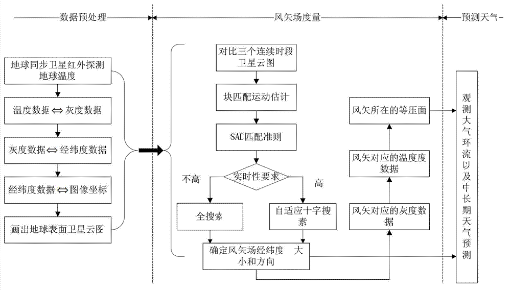
[0047] figure 1 is a schematic diagram of a specific embodiment of the present invention, such as figure 1 As shown, the process includes the following steps:

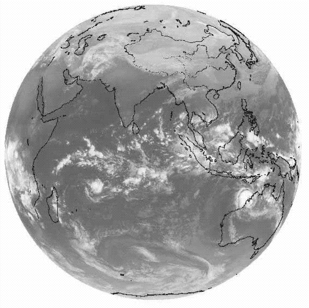
[0048] Step 1: Preprocessing of satellite detecti...


PUM


Abstract

The invention discloses a wind arrow field real-time measuring method based on satellite cloud pictures, and belongs to the field of image processing and sports estimation. The wind arrow field real-time measuring method based on the satellite cloud pictures solves the problem that a prior model is complex in calculation, not strong in real-time performance, and not high in algorithm searching efficiency. Earth temperature data which are detected are converted to gray scale data, the gray scale data are converted to longitude-latitude data, and then the longitude-latitude data are converted to image coordinates, and satellite cloud picture data are displayed in an image form. Satellite cloud pictures of three continuous times are compared, block matching is conducted on the satellite cloud pictures, and then different searching methods are selected according to real-time performance requirements, and longitude of a wind arrow field, latitude of the wind arrow field, and the direction of the wind arrow field are confirmed. Data preprocessing and a searching result are synthesized so as to further acquire a gray scale of each wind arrow, the temperature of the each wind arrow, and a barometric surface where the each wind arrow is located. Finally, general circulation of atmosphere and medium-and-long-term weather forecasts can be observed according to positions of the wind arrow field on the satellite cloud pictures, the size of the wind arrow field, the direction of the wind arrow field, and the barometric surface where the each wind arrow is located. The wind arrow field real-time measuring method based on the satellite cloud pictures avoids complex calculation when large-data-volume image processing of the satellite cloud pictures is conducted, is high in practicality, and improves system execution efficiency of a system.

Description

technical field [0001] The invention relates to a strong real-time and high-efficiency measurement method of a wind vector field based on a satellite cloud image, and belongs to the field of image processing and motion estimation. Background technique [0002] Satellite cloud images play an important role in mastering atmospheric circulation, mid- and long-term weather forecasts, and research on disastrous weather. It is made by the infrared detector on the geosynchronous satellite to detect the temperature data above the earth and then convert it into grayscale data. Cloud trace wind is very important for global weather and typhoon analysis and for providing numerical pre-initial wind field data. Yunjifeng has now become an important satellite product. It can be used as supplementary data for conventional wind measurements of land observation networks, and it is the main or only source of wind information in areas with few or no stations such as oceans, plateaus, and dese...

Claims


Application Information

Patent Timeline
IPC IPC(8): G06T1/00G06T7/20G01W1/00G01W1/10
CPCY02A90/10
Inventor 刘晓锋周建人郭庆杨明川王振永王明慧邹贵崔晓秋
Owner HARBIN INST OF TECH
Learn More