Estimation method of terrain azimuth angle under vegetation cover based on polarimetric synthetic aperture radar

An azimuth and vegetation technology, applied in the field of radar remote sensing image processing, can solve the problems of inability to obtain DEM information under vegetation, inability to produce large-scale production, and economic cost constraints.

Inactive Publication Date: 2013-06-12
WUHAN UNIV
View PDF4 Cites 4 Cited by
  • Summary
  • Abstract
  • Description
  • Claims
  • Application Information

AI Technical Summary

Problems solved by technology

Although the country launched the western side map plan during the "Eleventh Five-Year Plan" period, the 1:50000 and 1:100000 scale three-dimensional topographic maps obtained by the joint application of synthetic aperture radar interferometry (INSAR) and optical technology have been considered for some difficult areas. Completed the mapping of most areas in difficult areas; however, for areas covered by forest vegetation, relying on INSAR technology and optical three-dimensional measurement technology cannot obtain DEM information under vegetation, and new methods must be used to obtain the topography of vegetation-covered areas
At present, using Polarimetric Interferometric Synthetic Aperture Radar (POLINSAR) technology to extract terrain under vegetation is a research hotspot at home and abroad, but using POLINSAR technology to extract terrain requires repeated observations of the same area, and repeated Observation is constrained by economic cost and cannot be produced on a large scale

Method used


Image

  • Estimation method of terrain azimuth angle under vegetation cover based on polarimetric synthetic aperture radar
  • Estimation method of terrain azimuth angle under vegetation cover based on polarimetric synthetic aperture radar
  • Estimation method of terrain azimuth angle under vegetation cover based on polarimetric synthetic aperture radar

Examples


Embodiment Construction

[0020] The technical solution of the present invention will be described in detail below in conjunction with the drawings and embodiments.

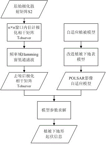
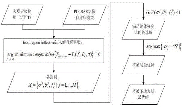
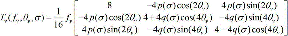
[0021] In order to extract the terrain under the vegetation, the embodiment of the present invention first needs to apply low-pass filtering to the original POLSAR radar image to remove the unstable random noise in the data. Each observed POLSAR image contains 4 channels of data. Since there is only a single observation of the POLSAR radar image, it is necessary to establish an appropriate vegetation and terrain scattering model under the vegetation to separate the two. This embodiment adopts the internationally well-known POLSAR vegetation layer model, and at the same time integrates the terrain fluctuation information under the vegetation into the terrain model, and uses an appropriate solution method to solve the terrain under the vegetation.

[0022] The technical scheme of the present invention can adopt computer technology to realiz...


PUM


Abstract

The invention belongs to the technical filed of radar remote control image processing, and provides an estimation method of a terrain azimuth angle under vegetation cover based on polarimetric synthetic aperture radar (POLSAR). By means of strong penetrability of the POLSAR, a vegetation cover area is observed once, and on the basis of an electromagnetic scattering theory and mathematical modeling, and topographic relief information under the vegetation cover in radar observation data is estimated. Due to the fact that earth surface observation can be carried out all day long in four seasons through the radar, and the topographic relief information under the estimated vegetation cover can provide sufficient guarantees for landslide detection, disaster emergency response, territorial resource annotation and others. Due to the fact that only one POLSAR image is used, economic expenses cost in buying radar data can be greatly reduced, and applicable ranges are greatly increased.

Description

technical field [0001] The invention belongs to the technical field of radar remote sensing image processing, and particularly designs a new method for estimating terrain under vegetation by using a Polarimetric Synthetic Aperture Radar (POLSAR). Background technique [0002] The digital terrain model is used to describe the spatial distribution of landforms. As the national basic surveying and mapping data, it is very important for the country's major infrastructure construction, resource development and utilization, ecological construction and environmental protection, as well as the positioning and navigation of targets in the military. significance. According to NASA statistics in 1983, about 33% of the world's land area is covered by forests. Due to the large amount of vegetation in these areas, the terrain obtained by traditional measurement methods cannot guarantee high accuracy. For some large areas covered by vegetation in my country and large areas of land in the ...

Claims


Application Information

Patent Timeline
Patent Type & Authority Applications(China)
IPC IPC(8): G01S13/90
Inventor 史磊杨杰李平湘
Owner WUHAN UNIV
Why Eureka
Try Eureka