Building three-dimensional change detection method based on LiDAR point cloud and image
A technology of change detection and building, applied in the field of surveying and mapping science, to achieve the effect of meeting the update speed
- Summary
- Abstract
- Description
- Claims
- Application Information
AI Technical Summary
Problems solved by technology
Method used
Image
Examples
Embodiment
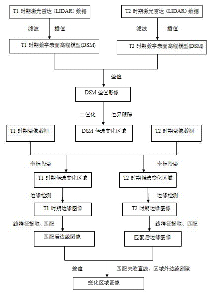
[0026] The specific implementation method of the embodiment includes the following steps:
[0027] Step 1, high-precision DSM generation: filter and interpolate LiDAR point cloud data in two different periods to generate two DSMs (digital surface elevation models).
[0028] The embodiment processes the original LiDAR point cloud data in two different periods, the old and the new, which are respectively recorded as LiDAR data in the T1 period and LiDAR data in the T2 period. First, filter the two phases of the original LiDAR point cloud to remove rough points (extremely high points, extremely low points, and noise points), and then perform triangulation interpolation (TIN interpolation) on the point cloud data that removes rough points, and use a certain color matching scheme, different colors represent different elevation values, and then generate two high-precision DSMs in different periods. The corresponding DSMs of the LiDAR data in the T1 period and the LiDAR data in the ...
PUM
 Abstract
Description
Claims
Application Information
 - R&D Engineer
- R&D Manager
- IP Professional
- Industry Leading Data Capabilities
- Powerful AI technology
- Patent DNA Extraction
Browse by: Latest US Patents, China's latest patents, Technical Efficacy Thesaurus, Application Domain, Technology Topic, Popular Technical Reports.
© 2024 PatSnap. All rights reserved.Legal|Privacy policy|Modern Slavery Act Transparency Statement|Sitemap|About US| Contact US: help@patsnap.com


